Fichier:Map Denmark Demis SE islands.gif
Pas de plus haute résolution disponible.
Map_Denmark_Demis_SE_islands.gif (415 × 420 pixels, taille du fichier : 23 kio, type MIME : image/gif)
Ce fichier et sa description proviennent de Wikimedia Commons.
Description
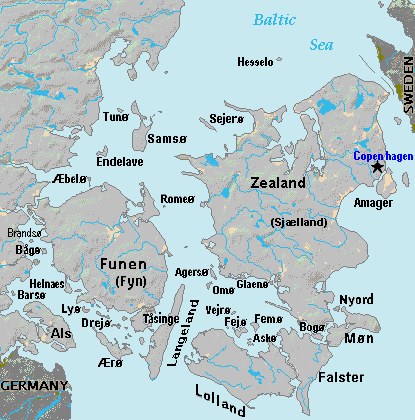
| Description | Terrain map of southeast Denmark, showing the major islands labeled, in the region between Germany and Sweden. The terrain data was extracted from the Demis map (on Wikimedia Commons) Image:La2-demis-denmark.png, and the extracted map was color-shifted to grayshade land areas (from the green Demis map). Labels are in font face Arial or Arial Narrow, sizes 8-10. |
| Date | |
| Source | Derivative of Demis map: Image:La2-demis-denmark.png |
| Auteur | Wikid77 (derivative of Demis map) |
Conditions d’utilisation
This image is in the public domain because it came from the site https://www.demis.nl/products/web-map-server/examples/ and was released by the copyright holder. Permission is granted to copy, distribute and/or modify this map since it is based on free of copyright images from: www.demis.nl. See also approval email on de.wp and its clarification.
|
| This work has been released into the public domain by its copyright holder, www.demis.nl. This applies worldwide. Dans certains pays, ceci peut ne pas être possible ; dans ce cas : www.demis.nl accorde à toute personne le droit d’utiliser cette œuvre dans n’importe quel but, sans aucune condition, sauf celles requises par la loi.
|
Historique du fichier
Cliquer sur une date et heure pour voir le fichier tel qu'il était à ce moment-là.
| Date et heure | Vignette | Dimensions | Utilisateur | Commentaire | |
|---|---|---|---|---|---|
| actuel | 3 septembre 2007 à 20:51 | | 415 × 420 (23 kio) | Wikid77 | added 14 island names |
| 2 septembre 2007 à 12:50 |  | 415 × 420 (22 kio) | Wikid77 | added "Sejero" + "Amager" | |
| 1 septembre 2007 à 14:56 |  | 415 × 420 (22 kio) | Wikid77 | cut height 10px for square/undistorted resizing; cut banner "DENMARK" to appear in banner version | |
| 1 septembre 2007 à 14:46 |  | 415 × 430 (22 kio) | Wikid77 | cut map width 10px as 415px magnified 3%; banner "DENMARK"; enlarged names; darkened Germany/Sweden | |
| 31 août 2007 à 15:36 |  | 425 × 430 (22 kio) | Wikid77 | Terrain map of southeast Denmark, showing the major islands labeled, in the region between Germany and Sweden. The terrain data was extracted from the Demis map (on Wikimedia Commons) Image:La2-demis-denmark.png , and the extracted map w |
Utilisation du fichier
La page suivante utilise ce fichier :
Usage global du fichier
Les autres wikis suivants utilisent ce fichier :
- Utilisation sur da.wikipedia.org
- Utilisation sur el.wikipedia.org
- Utilisation sur en.wikipedia.org
- Utilisation sur es.wikipedia.org
- Utilisation sur fi.wikipedia.org
- Utilisation sur gl.wikipedia.org
- Utilisation sur hr.wikipedia.org
- Utilisation sur it.wikipedia.org
- Utilisation sur ka.wikipedia.org
- Utilisation sur la.wikipedia.org
- Utilisation sur lt.wikipedia.org
- Utilisation sur pt.wikipedia.org
- Utilisation sur sl.wikipedia.org
- Utilisation sur vi.wikipedia.org
- Utilisation sur zh.wikipedia.org