Fichier:Laura intensification and landfall satellite loop.gif
Pas de plus haute résolution disponible.
Laura_intensification_and_landfall_satellite_loop.gif (720 × 576 pixels, taille du fichier : 43,9 Mio, type MIME : image/gif, en boucle, 228 trames, 6,8 s)
Ce fichier et sa description proviennent de Wikimedia Commons.
Description
| Description |
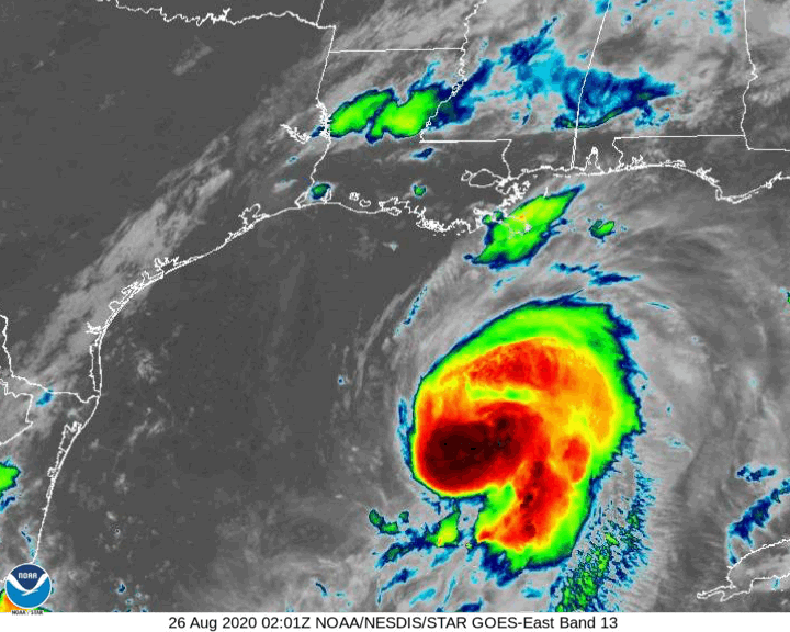
English: Hurricane Laura satellite loop (August 26 02:00 UTC-August 27 12:00 UTC) covering rapid intensification and landfall in Louisiana.
Italiano: Sequenza di immagini satellitari dell'uragano Laura (26 agosto 02:00 UTC-27 agosto 12:00 UTC) che copre la fase di rapida intensificazione e dell'approdo in Louisiana. |
| Date | |
| Source | https://www.star.nesdis.noaa.gov/GOES/sector_band.php?sat=G16§or=gm&band=13&length=240 |
| Auteur | NOAA, edited by L9A8M |
Conditions d’utilisation
Cette image est dans le domaine public car son contenu provient de la
National Oceanic and Atmospheric Administration , réalisé par un employé dans le cadre de ses activités professionnelles.
|
Historique du fichier
Cliquer sur une date et heure pour voir le fichier tel qu'il était à ce moment-là.
| Date et heure | Vignette | Dimensions | Utilisateur | Commentaire | |
|---|---|---|---|---|---|
| actuel | 27 août 2020 à 17:02 | | 720 × 576 (43,9 Mio) | L9A8M | Uploaded a work by NOAA, edited by L9A8M from https://www.star.nesdis.noaa.gov/GOES/sector_band.php?sat=G16§or=gm&band=13&length=240 with UploadWizard |
Utilisation du fichier
La page suivante utilise ce fichier :
Usage global du fichier
Les autres wikis suivants utilisent ce fichier :
- Utilisation sur it.wikipedia.org