Fichier:Kansas City Southern Railway system map.svg

Taille de cet aperçu PNG pour ce fichier SVG : 800 × 457 pixels. Autres résolutions : 320 × 183 pixels | 640 × 366 pixels | 1 024 × 585 pixels | 1 280 × 731 pixels | 2 560 × 1 463 pixels | 1 400 × 800 pixels.
Fichier d’origine (Fichier SVG, nominalement de 1 400 × 800 pixels, taille : 543 kio)
Ce fichier et sa description proviennent de Wikimedia Commons.
Description
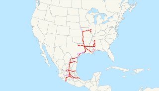
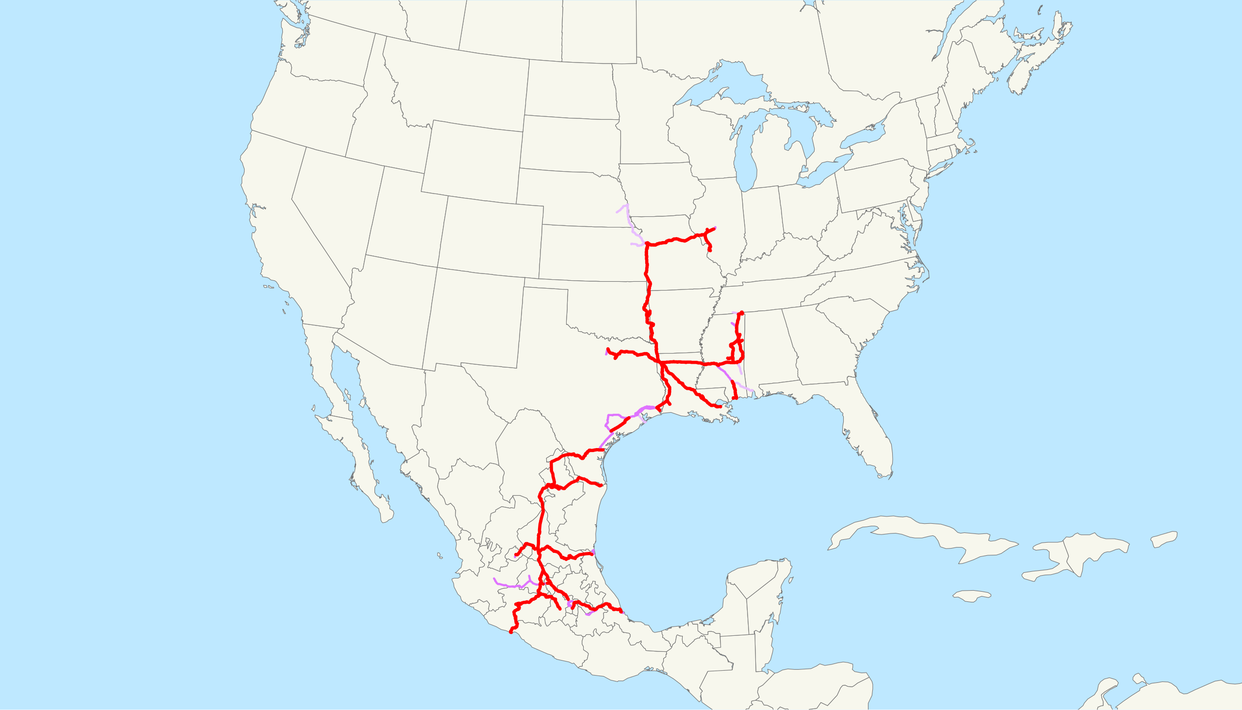
| Description | This is a map of the Kansas City Southern Railway as of 2009, with trackage rights in purple (haulage rights are lighter). Email me if you would like a copy of the GIS data I created (modified from Bureau of Transportation Statistics North American Transportation Atlas Data) or if you see any errors. |
| Date | 20 février 2009 (date de téléversement originale) |
| Source | La source n’a pas pu être reconnue automatiquement. « Travail personnel » supposé (étant donné la revendication de droit d’auteur). |
| Auteur | L’auteur n’a pas pu être identifié automatiquement. Il est supposé qu'il s'agit de : NE2 (étant donné la revendication de droit d’auteur). |
Conditions d’utilisation
| Moi, propriétaire des droits d’auteur sur cette œuvre, la place dans le domaine public. Ceci s'applique dans le monde entier. Dans certains pays, ceci peut ne pas être possible ; dans ce cas : J’accorde à toute personne le droit d’utiliser cette œuvre dans n’importe quel but, sans aucune condition, sauf celles requises par la loi. |
Historique du fichier
Cliquer sur une date et heure pour voir le fichier tel qu'il était à ce moment-là.
| Date et heure | Vignette | Dimensions | Utilisateur | Commentaire | |
|---|---|---|---|---|---|
| actuel | 23 février 2009 à 15:09 | | 1 400 × 800 (543 kio) | NE2 | Changed the display of lines owned by the government for the purposes of passenger rail, so that if KCS is the primary freight operator it is not shown as trackage rights. |
| 20 février 2009 à 06:30 |  | 1 400 × 800 (542 kio) | NE2 | == Summary == This is a map of the Kansas City Southern Railway as of 2009, with trackage rights in purple (haulage rights are lighter). Email me if you would like a copy of the GIS dat |
Utilisation du fichier
La page suivante utilise ce fichier :
Usage global du fichier
Les autres wikis suivants utilisent ce fichier :
- Utilisation sur de.wikipedia.org
- Utilisation sur en.wikipedia.org
- Utilisation sur es.wikipedia.org
- Utilisation sur hu.wikipedia.org
- Utilisation sur id.wikipedia.org
- Utilisation sur it.wikipedia.org
- Utilisation sur ja.wikipedia.org
- Utilisation sur ko.wikipedia.org
- Utilisation sur nl.wikipedia.org
- Utilisation sur pt.wikipedia.org
- Utilisation sur www.wikidata.org
- Utilisation sur zh.wikipedia.org