Fichier:Island of Ireland location map Clare.svg

Taille de cet aperçu PNG pour ce fichier SVG : 481 × 599 pixels. Autres résolutions : 192 × 240 pixels | 385 × 480 pixels | 616 × 768 pixels | 822 × 1 024 pixels | 1 643 × 2 048 pixels | 1 450 × 1 807 pixels.
Fichier d’origine (Fichier SVG, nominalement de 1 450 × 1 807 pixels, taille : 642 kio)
Ce fichier et sa description proviennent de Wikimedia Commons.
| Description |
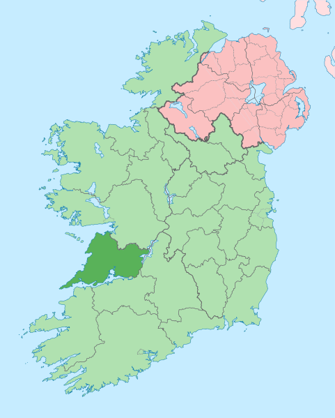
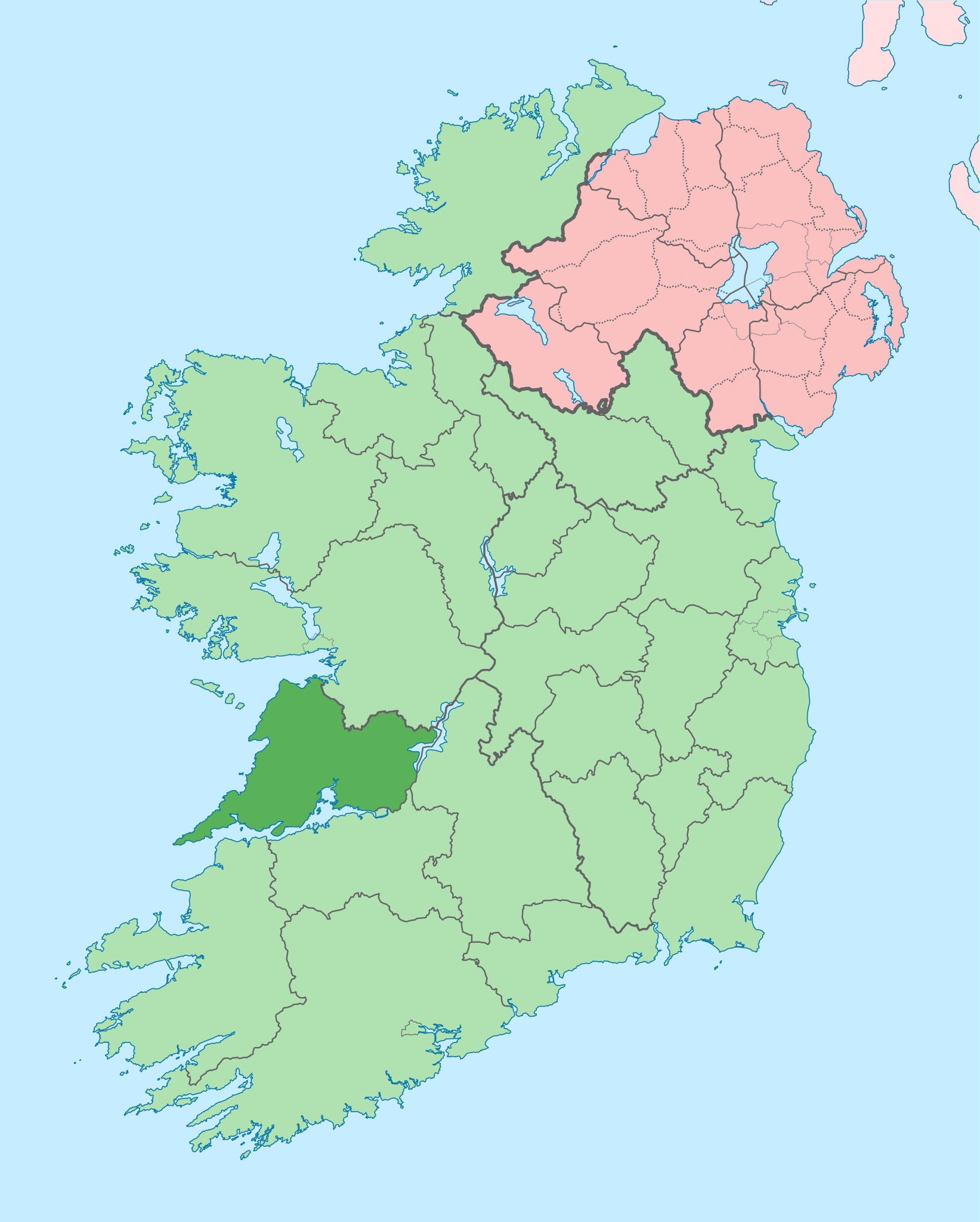
English: The island of Ireland, showing international border between Ireland and Northern Ireland, traditional provinces, traditional counties, and local authority areas in Ireland and Northern Ireland. |
| Date | (UTC) |
| Source | |
| Auteur |
|
| Cette image a été retouchée, ce qui signifie qu'elle a été modifiée par ordinateur et est différente de l'image d'origine. Liste des modifications : Coloured in regions with county of article highlighted. L'image d'origine se trouve ici : Island of Ireland location map.svg:
|
Moi, en tant que détenteur des droits d’auteur sur cette œuvre, je la publie sous la licence suivante :
Ce fichier est disponible selon les termes de la licence Creative Commons Attribution – Partage dans les Mêmes Conditions 3.0 (non transposée).
- Vous êtes libre :
- de partager – de copier, distribuer et transmettre cette œuvre
- d’adapter – de modifier cette œuvre
- Sous les conditions suivantes :
- paternité – Vous devez donner les informations appropriées concernant l'auteur, fournir un lien vers la licence et indiquer si des modifications ont été faites. Vous pouvez faire cela par tout moyen raisonnable, mais en aucune façon suggérant que l’auteur vous soutient ou approuve l’utilisation que vous en faites.
- partage à l’identique – Si vous modifiez, transformez, ou vous basez sur cette œuvre, vous devez distribuer votre contribution sous la même licence ou une licence compatible avec celle de l’original.
Journal des téléversements d’origine
This image is a derivative work of the following images:
- File:Island_of_Ireland_location_map.svg licensed with Cc-by-sa-3.0
- 2010-03-06T20:43:33Z Rannpháirtí anaithnid 1450x1807 (679207 Bytes) Fix incorrectly coloured isands.
- 2010-03-03T22:19:29Z Rannpháirtí anaithnid 1450x1807 (679744 Bytes) {{Information |Description={{de|Positionskarte von [[:de:Irland|Irland]]}} Quadratische Plattkarte, N-S-Streckung 170 %. Geographische Begrenzung der Karte: * N: 55.6° N * S: 51.2° N * W: 11.0° W * O: 5.0° W {{en|Location
Téléversé avec derivativeFX
Historique du fichier
Cliquer sur une date et heure pour voir le fichier tel qu'il était à ce moment-là.
| Date et heure | Vignette | Dimensions | Utilisateur | Commentaire | |
|---|---|---|---|---|---|
| actuel | 28 juin 2020 à 16:05 | | 1 450 × 1 807 (642 kio) | Chipmunkdavis | Colouring in Aughinish |
| 26 juin 2020 à 17:54 |  | 1 450 × 1 807 (642 kio) | Chipmunkdavis | Rmv stray number in code | |
| 26 juin 2020 à 17:26 |  | 1 450 × 1 807 (642 kio) | Chipmunkdavis | Merging Tipperary and Waterford shapes | |
| 26 juin 2020 à 14:55 |  | 1 450 × 1 807 (643 kio) | Chipmunkdavis | Removing Limerick City | |
| 25 juin 2020 à 18:21 |  | 1 450 × 1 807 (643 kio) | Chipmunkdavis | Per the Local Government Reform Act 2014, removing the Tipperary border and the Waterford City border. | |
| 25 juin 2020 à 18:10 |  | 1 450 × 1 807 (646 kio) | Chipmunkdavis | Removing lots of stray objects. Fixing location of Clare and one island slightly. | |
| 25 juin 2020 à 17:45 |  | 1 450 × 1 807 (695 kio) | Chipmunkdavis | Colour islands in, place all islands and borders in groups, remove some blank and redundant shapes | |
| 19 juillet 2010 à 02:41 |  | 1 450 × 1 807 (815 kio) | Mabuska | {{Information |Description={{en|The island of Ireland, showing international border between Northern Ireland and Republic of Ireland, traditional provinces, traditional counties, and local authority areas in the Republic of Ireland and Northern Ireland.}} |
Utilisation du fichier
Les 77 pages suivantes utilisent ce fichier :
- Ardnacrusha
- Aughinish (comté de Clare)
- Ballynacally
- Ballyvaughan
- Barefield
- Bodyke
- Boston (comté de Clare)
- Bridgetown (comté de Clare)
- Broadford (comté de Clare)
- Cahiracon
- Carrigaholt
- Clarecastle
- Clonlara
- Cloonanaha
- Comté d'Irlande
- Comté de Clare
- Connolly (comté de Clare)
- Cooraclare
- Coore
- Corofin
- Cranny
- Cratloe
- Cree (comté de Clare)
- Cross (comté de Clare)
- Crusheen
- Doolin
- Doonaha
- Doonbeg
- Ennis
- Ennistymon
- Fanore
- Feakle
- Hurlers Cross
- Inagh
- Ivarstown
- Kilbaha
- Kildysart
- Kilfenora
- Kilkee
- Kilkishen
- Killaloe
- Killimer
- Kilmihil
- Kilnaboy
- Kilnamona
- Kilrush
- Kilshanny
- Knock (comté de Clare)
- Labasheeda
- Lahinch
- Liscannor
- Lisdoonvarna
- Lissycasey
- Meelick (comté de Clare)
- Milltown Malbay
- Mountshannon
- Moyasta
- Mullagh (comté de Clare)
- Murroogh
- Newmarket-on-Fergus
- Noughaval (comté de Clare)
- O'Brien's Bridge
- O'Callaghan's Mills
- Parteen
- Quilty (comté de Clare)
- Quin (comté de Clare)
- Ruan (comté de Clare)
- Scarriff
- Shannon (Irlande)
- Sixmilebridge
- Spancill Hill
- Spanish Point
- Tuamgraney
- Tulla
- Tullig (comté de Clare)
- Whitegate (comté de Clare)
- Modèle:Palette Localités du comté de Clare
Usage global du fichier
Les autres wikis suivants utilisent ce fichier :
- Utilisation sur ar.wikipedia.org
- Utilisation sur ast.wikipedia.org
- Utilisation sur bg.wikipedia.org
- Utilisation sur ca.wikipedia.org
- Utilisation sur ceb.wikipedia.org
- Utilisation sur cs.wikipedia.org
- Utilisation sur en.wikipedia.org
- County Clare
- Inagh
- Ennis
- List of Ireland-related topics
- Shannon, County Clare
- Lissycasey
- Shannon Free Zone
- Lisdoonvarna
- Cratloe
- Doolin
- Kilfenora
- Ballyvaughan
- Carran
- Kilkee
- Kilrush
- Clarecastle
- Ennistymon
- Killaloe, County Clare
- Lahinch
- Liscannor
- Mountshannon
- Newmarket-on-Fergus
- O'Brien's Bridge
- Spanish Point, County Clare
- Aughinish, County Clare
Voir davantage sur l’utilisation globale de ce fichier.