Fichier:Indiana Monument Antietam 085333pr.jpg
Fichier d’origine (362 × 605 pixels, taille du fichier : 29 kio, type MIME : image/jpeg)
Ce fichier et sa description proviennent de Wikimedia Commons.
Description
Transwiki approved by: w:en:User:Dmcdevit
This image was copied from wikipedia:en. The original description was:
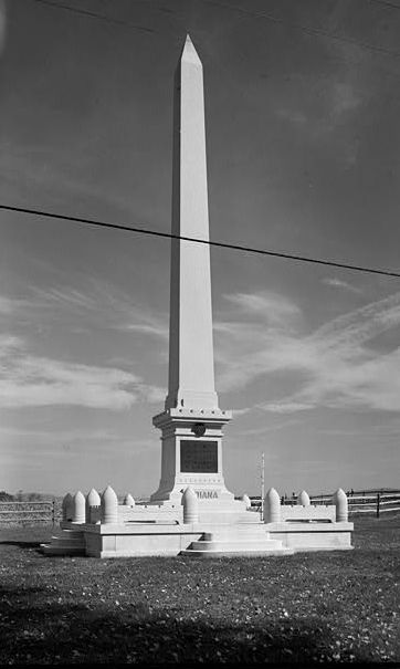
This is a cropped version of a photo made in 1989 by w:en:Jack E. Boucher of the Historic American Buildings Survey of the monument at the w:en:Antietam National Battlefield commemorating the 7th, 14th, 19th and 27th Indiana infantry regiments and the w:en:3rd Regiment Indiana Cavalry (East Wing). The "cornfield" is in background. Monument erected in 1910. The photo is no. 23 of a series of 110.
Antietam National Battlefield, Sharpsburg vicinity, Washington County, MD
CALL NUMBER: HABS MD,22-SHARP.V,9-23
REPRODUCTION NUMBER: See Call Number
MEDIUM: Photo(s): 110 (5 x 7 in.) Color Transparencies: 1
DATE: Documentation compiled after 1933.
CREATOR: Historic American Buildings Survey, creator
RELATED NAME(S): Mansfield, Maj Gen. Joseph K. F. Stetson, Lt Col. John L. Starke, Brig Gen. William E. Anderson Richardson, Israel McKinley, Sgt. William Boucher, Jack E., photographer Boucher, Jack E., photographer
NOTE: Survey number HABS MD-934
SUBJECTS: MARYLAND--Washington County--Sharpsburg vicinity war (Civil War) battlefields
OTHER TITLE: Antietam National Battlefield
COLLECTION: Historic American Buildings Survey (Library of Congress)
REPOSITORY: Library of Congress, Prints and Photograph Division, Washington, D.C. 20540 USA
DIGID: [1]
CONTENTS: Photograph caption(s):
23. INDIANA STATE (7TH, 14TH, 19TH & 27TH INFANTRY & 30TH CAVALRY [sic, unit was 3rd Cav.]) MONUMENT, NORTH SIDE OF CORNFIELD AVENUE AT INTERSECTION OF OLD HAGERSTOWN PIKE HABS MD,22-SHARP.V,9-23
CARD #: MD1073
Conditions d’utilisation

|
Ce fichier provient de Historic American Buildings Survey (HABS), Historic American Engineering Record (HAER) or Historic American Landscapes Survey (HALS). Il s'agit de programmes du Service des parcs nationaux, mis en place afin d'établir une documentation sur les lieux historiques. Les enregistrements consistent en des dessins côtés, des photographies à des fins d'archivage et des rapports écrits.
Ce bandeau n’indique rien sur le statut de l’œuvre au regard du droit d'auteur. Un bandeau de droit d’auteur est requis. Voir Commons:À propos des licences pour plus d’informations. |
| Cette image ou ce document multimédia contient des éléments basés sur une œuvre d'un employé du National Park Service, créé dans le cadre des tâches officielles de cette personne. En tant qu'œuvre du Gouvernement fédéral des États-Unis, une telle œuvre se trouve dans le domaine public aux États-Unis. Voir NPS website et NPS copyright policy pour plus d'informations. |
Historique du fichier
Cliquer sur une date et heure pour voir le fichier tel qu'il était à ce moment-là.
| Date et heure | Vignette | Dimensions | Utilisateur | Commentaire | |
|---|---|---|---|---|---|
| actuel | 13 septembre 2007 à 18:15 | | 362 × 605 (29 kio) | BetacommandBot | Transwiki approved by: w:en:User:Dmcdevit This image was copied from wikipedia:en. The original description was: This is a cropped version of a photo made in 1989 by w:en:Jack E. Boucher of the Historic American Buildings Survey of the monument |
Utilisation du fichier
La page suivante utilise ce fichier :
Usage global du fichier
Les autres wikis suivants utilisent ce fichier :
- Utilisation sur en.wikipedia.org