Fichier:Hurricane Paula 2010-10-12 1620Z.jpg
Taille de cet aperçu : 600 × 600 pixels. Autres résolutions : 240 × 240 pixels | 480 × 480 pixels | 768 × 768 pixels | 1 024 × 1 024 pixels | 2 048 × 2 048 pixels | 5 600 × 5 600 pixels.
Fichier d’origine (5 600 × 5 600 pixels, taille du fichier : 8,06 Mio, type MIME : image/jpeg)
Ce fichier et sa description proviennent de Wikimedia Commons.
Description
| Description |
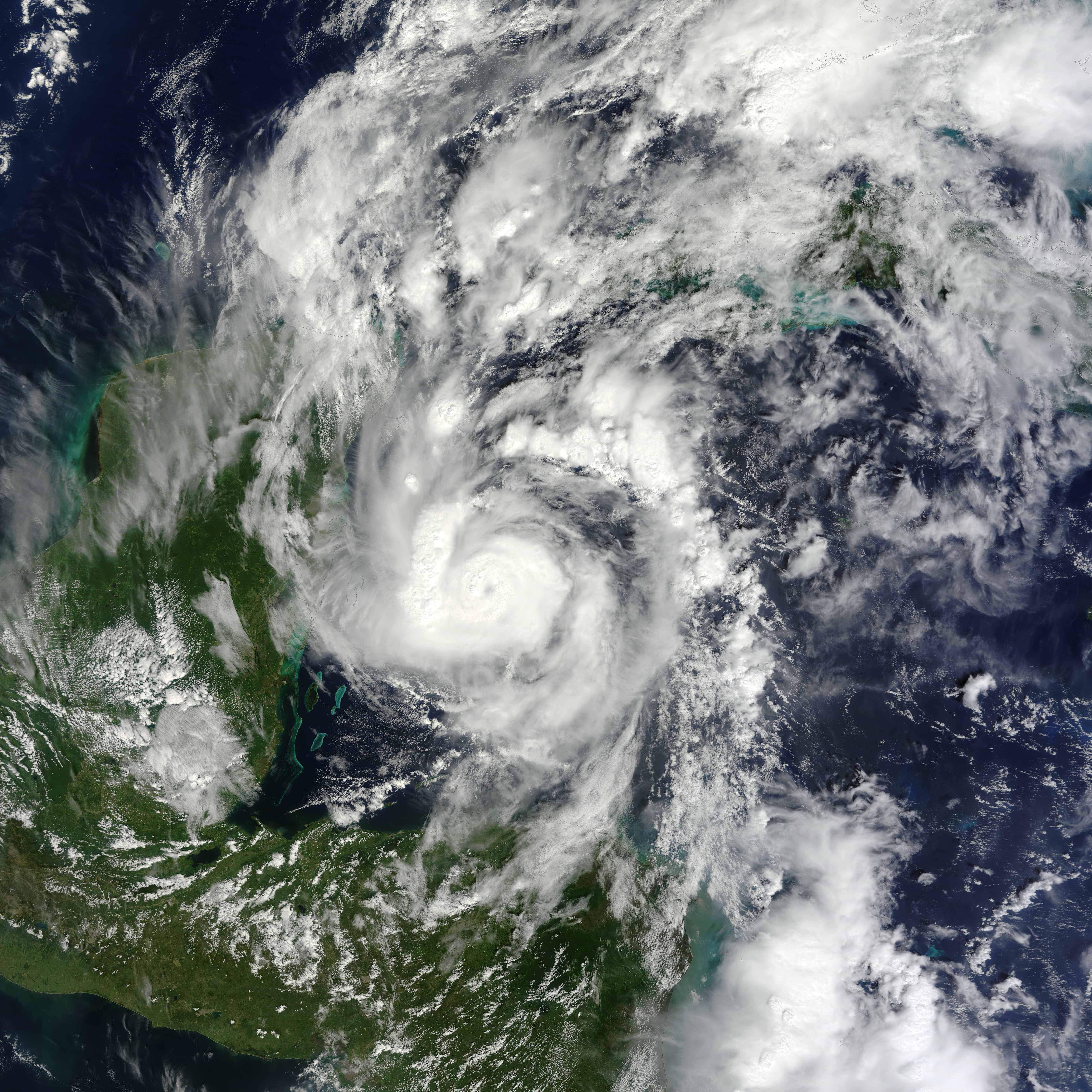
English: Small but powerful, Hurricane Paula packed winds of 100 miles (160 kilometers) per hour on October 12, 2010. At 12:45 p.m. Central Daylight Time (CDT), the U.S. National Hurricane Center (NHC) reported that Paula was a Category 2 hurricane, located roughly 140 miles (220 kilometers) south-southeast of Cozumel, Mexico, and was traveling slowly toward the north-northwest.
The Moderate Resolution Imaging Spectroradiometer (MODIS) on NASA’s Terra satellite captured this natural-color image of Hurricane Paula at 11:20 a.m. CDT (16:20 UTC) on October 12 while over the Caribbean Sea, just off the coasts of Mexico, Belize, and Honduras. Coiled around a distinct eye, the storm’s most intense clouds spanned roughly 200 kilometers (125 miles). By October 14, 2010, Paula had weakened to a tropical storm. At 10:00 a.m. CDT on October 14, the NHC reported that Paula had winds of 70 miles (110 kilometers) per hour. Though less intense than it had been two days earlier, Paula still posed hazards. A tropical storm warning was in effect for parts of Cuba, and a tropical storm watch was in effect for parts of the Florida Keys. The NHC warned of high winds and heavy rains—amounting to 10 inches (25 centimeters) in isolated areas. |
| Date | |
| Source | [1] |
| Auteur | NASA image by Jeff Schmaltz, MODIS Rapid Response Team at NASA GSFC. Caption by Michon Scott. |
Conditions d’utilisation
| Ce fichier provient de la NASA. Sauf exception, les documents créés par la NASA ne sont pas soumis à copyright. Pour plus d'informations, voir la politique de copyright de la NASA. | ||
 |
Attention :
|
Historique du fichier
Cliquer sur une date et heure pour voir le fichier tel qu'il était à ce moment-là.
| Date et heure | Vignette | Dimensions | Utilisateur | Commentaire | |
|---|---|---|---|---|---|
| actuel | 28 juin 2013 à 05:33 | | 5 600 × 5 600 (8,06 Mio) | HurricaneSpin | cropped |
| 13 octobre 2010 à 00:56 |  | 5 600 × 7 200 (6,19 Mio) | HurricaneSpin | {{Information |Description={{en|1=Hurricane Paula.}} |Source=[http://rapidfire.sci.gsfc.nasa.gov/gallery/?2010285-1012/Paula.A2010285.1620.2km.jpg] |Author=NASA/MODIS Rapid Response System |Date=2010-10-12 |Permission=See below |other_versions= }} [[Cate |
Utilisation du fichier
La page suivante utilise ce fichier :
Usage global du fichier
Les autres wikis suivants utilisent ce fichier :
- Utilisation sur de.wikipedia.org
- Utilisation sur en.wikipedia.org
- Utilisation sur en.wikinews.org
- Utilisation sur es.wikipedia.org
- Utilisation sur ko.wikipedia.org
- Utilisation sur nl.wikipedia.org
- Utilisation sur pt.wikipedia.org
- Utilisation sur simple.wikipedia.org
- Utilisation sur www.wikidata.org
- Utilisation sur zh.wikipedia.org