Fichier:Hurricane Erin 2001.jpg

Fichier d’origine (4 400 × 4 400 pixels, taille du fichier : 2,79 Mio, type MIME : image/jpeg)
Ce fichier et sa description proviennent de Wikimedia Commons.
Description
| Description |
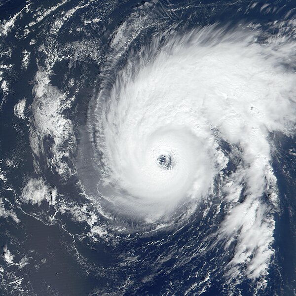
The first Atlantic hurricane of the 2001 season narrowly missed Bermuda yesterday (September 9) as it churned north-northwestward at a rate of 19 km per hour (12 miles per hour). Packing sustained winds of 195 km per hour (120 miles per hour), Hurricane Erin was located just east of Bermuda at the time NASA's Terra satellite acquired this image. The true-color image was produced using data from the Moderate-resolution Imaging Spectroradiometer (MODIS). The U.S. National Hurricane Center predicts that tonight the storm will shift to a more northerly path. The Center says there is still the possibility that Hurricane Erin could impact Canada, somewhere along the coast of Newfoundland, within three to four days. Hurricane Erin was upgraded from a tropical storm to hurricane status on September 8, and was listed as a Category 3 hurricane on September 10 on the Saffir-Simpson scale. The storm's hurricane-force winds extend outward in a 75-km (45-mile) radius from its center, with tropical storm force winds extending to 280 km (175 miles) from center. |
|||||
| Date | ||||||
| Source | http://earthobservatory.nasa.gov/Newsroom/NewImages/images.php3?img_id=5153 | |||||
| Auteur | Image courtesy Jacques Descloitres, MODIS Land Rapid Response Team at NASA GSFC | |||||
| Autorisation (Réutilisation de ce fichier) |
|
|||||
| Autres versions | Image:Hurricane Erin 09 sept 2001 1527Z.jpg |

Historique du fichier
Cliquer sur une date et heure pour voir le fichier tel qu'il était à ce moment-là.
| Date et heure | Vignette | Dimensions | Utilisateur | Commentaire | |
|---|---|---|---|---|---|
| actuel | 23 août 2006 à 20:57 | | 4 400 × 4 400 (2,79 Mio) | Good kitty | {{Information |Description=The first Atlantic hurricane of the 2001 season narrowly missed Bermuda yesterday (September 9) as it churned north-northwestward at a rate of 19 km per hour (12 miles per hour). Packing sustained winds of 195 km per hour (120 m |
Utilisation du fichier
La page suivante utilise ce fichier :
Usage global du fichier
Les autres wikis suivants utilisent ce fichier :
- Utilisation sur en.wikipedia.org
- Utilisation sur simple.wikipedia.org
- Utilisation sur zh.wikipedia.org