Fichier:Greater London boroughs 2009 map.svg

Fichier d’origine (Fichier SVG, nominalement de 1 425 × 1 140 pixels, taille : 761 kio)
Ce fichier et sa description proviennent de Wikimedia Commons.
Description
| Description |
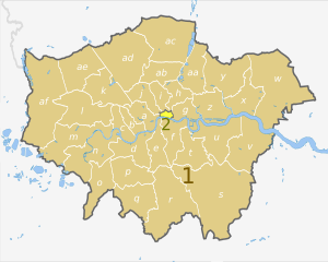
English: Map of Greater London, UK with districts shown, in the same style as other maps of English regions. The county colours are the same as those in File:English metropolitan and non-metropolitan counties 2009.svg.
Equirectangular map projection on WGS 84 datum, with N/S stretched 160%. Geographic limits:
|
| Date | (UTC) |
| Source |
Ce fichier est dérivé de : Greater London UK district map (blank).svg: |
| Auteur |
|
.svg)
| Map | Ceremonial county | London boroughs |
|---|---|---|
 |
1. Greater London |
a) City of Westminster, b) Kensington and Chelsea, c) Hammersmith and Fulham, d) Wandsworth, e) Lambeth, f) Southwark, g) Tower Hamlets, h) Hackney, i) Islington, j) Camden, k) Brent, l) Ealing, m) Hounslow, n) Richmond, o) Kingston upon Thames, p) Merton, q) Sutton, r) Croydon, s) Bromley, t) Lewisham, u) Greenwich, v) Bexley, w) Havering, x) Barking and Dagenham, y) Redbridge, z) Newham, aa) Waltham Forest, ab) Haringey, ac) Enfield, ad) Barnet, ae) Harrow, af) Hillingdon |
| 2. City of London | ||
| Cette image a été retouchée, ce qui signifie qu'elle a été modifiée par ordinateur et est différente de l'image d'origine. Liste des modifications : recoloured and labelled in same style as other English regional maps. L'image d'origine se trouve ici : Greater London UK district map (blank).svg:
|
Conditions d’utilisation
- Vous êtes libre :
- de partager – de copier, distribuer et transmettre cette œuvre
- d’adapter – de modifier cette œuvre
- Sous les conditions suivantes :
- paternité – Vous devez donner les informations appropriées concernant l'auteur, fournir un lien vers la licence et indiquer si des modifications ont été faites. Vous pouvez faire cela par tout moyen raisonnable, mais en aucune façon suggérant que l’auteur vous soutient ou approuve l’utilisation que vous en faites.
- partage à l’identique – Si vous modifiez, transformez, ou vous basez sur cette œuvre, vous devez distribuer votre contribution sous la même licence ou une licence compatible avec celle de l’original.
Journal des téléversements d’origine
This image is a derivative work of the following images:
- File:Greater_London_UK_district_map_(blank).svg licensed with Cc-by-sa-3.0
- 2010-08-22T08:09:33Z Nilfanion 1425x1140 (1104179 Bytes) +inset, water colour tweak
- 2010-07-16T23:35:33Z Nilfanion 1425x1140 (738807 Bytes) {{Information |Description=Map of [[w:Greater London|Greater London]], UK with districts shown. Equirectangular map projection on WGS 84 datum, with N/S stretched 160% Geographic limits: *West: 0.57W *East: 0.37E *North: 51
Téléversé avec derivativeFX
Historique du fichier
Cliquer sur une date et heure pour voir le fichier tel qu'il était à ce moment-là.
| Date et heure | Vignette | Dimensions | Utilisateur | Commentaire | |
|---|---|---|---|---|---|
| actuel | 3 mai 2012 à 00:05 | | 1 425 × 1 140 (761 kio) | Dr Greg | == {{int:filedesc}} == {{Information |Description={{en|Map of Greater London, UK with districts shown, in the same style as other maps of English regions. The county colours are the same as those in [[:File:English metropolitan and... |
Utilisation du fichier
La page suivante utilise ce fichier :
Usage global du fichier
Les autres wikis suivants utilisent ce fichier :
- Utilisation sur ar.wikipedia.org
- Utilisation sur de.wikipedia.org
- Utilisation sur en.wikipedia.org
- Utilisation sur pnb.wikipedia.org
- Utilisation sur th.wikipedia.org
- Utilisation sur ur.wikipedia.org
- Utilisation sur zh-yue.wikipedia.org