Fichier:Fergana Valley map-de.svg

Taille de cet aperçu PNG pour ce fichier SVG : 800 × 599 pixels. Autres résolutions : 320 × 240 pixels | 640 × 479 pixels | 1 024 × 767 pixels | 1 280 × 958 pixels | 2 560 × 1 917 pixels | 840 × 629 pixels.
Fichier d’origine (Fichier SVG, nominalement de 840 × 629 pixels, taille : 1,22 Mio)
Ce fichier et sa description proviennent de Wikimedia Commons.
Description
| Description |
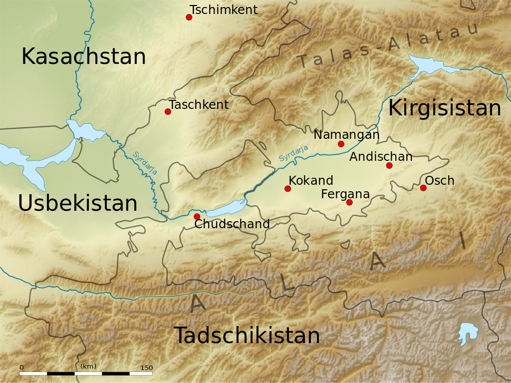
English: Map of the Fergana Valley.
Equirectangular projection. Strechted by 131.0%. Geographic limits of the map:
|
| Date | |
| Source | Travail personnel |
| Auteur | Uwe Dedering |
| Autres versions |
|

Conditions d’utilisation
Moi, en tant que détenteur des droits d’auteur sur cette œuvre, je la publie sous les licences suivantes :
Ce fichier est disponible selon les termes de la licence Creative Commons Attribution – Partage dans les Mêmes Conditions 3.0 (non transposée).
- Vous êtes libre :
- de partager – de copier, distribuer et transmettre cette œuvre
- d’adapter – de modifier cette œuvre
- Sous les conditions suivantes :
- paternité – Vous devez donner les informations appropriées concernant l'auteur, fournir un lien vers la licence et indiquer si des modifications ont été faites. Vous pouvez faire cela par tout moyen raisonnable, mais en aucune façon suggérant que l’auteur vous soutient ou approuve l’utilisation que vous en faites.
- partage à l’identique – Si vous modifiez, transformez, ou vous basez sur cette œuvre, vous devez distribuer votre contribution sous la même licence ou une licence compatible avec celle de l’original.

|
Vous avez la permission de copier, distribuer et modifier ce document selon les termes de la GNU Free Documentation License version 1.2 ou toute version ultérieure publiée par la Free Software Foundation, sans sections inaltérables, sans texte de première page de couverture et sans texte de dernière page de couverture. Un exemplaire de la licence est inclus dans la section intitulée GNU Free Documentation License. |
Vous pouvez choisir l’une de ces licences.
Historique du fichier
Cliquer sur une date et heure pour voir le fichier tel qu'il était à ce moment-là.
| Date et heure | Vignette | Dimensions | Utilisateur | Commentaire | |
|---|---|---|---|---|---|
| actuel | 19 juin 2010 à 15:48 | | 840 × 629 (1,22 Mio) | Uwe Dedering | +Chudschand |
| 18 juin 2010 à 20:44 |  | 840 × 629 (1,22 Mio) | Uwe Dedering | no text on path | |
| 18 juin 2010 à 20:36 |  | 840 × 629 (1,22 Mio) | Uwe Dedering | more minor changes | |
| 18 juin 2010 à 19:17 |  | 840 × 629 (1,22 Mio) | Uwe Dedering | some minor edits | |
| 18 juin 2010 à 17:46 |  | 840 × 629 (1,23 Mio) | Uwe Dedering | some improvments | |
| 17 juin 2010 à 14:53 |  | 840 × 629 (1,23 Mio) | Uwe Dedering | image embedded | |
| 17 juin 2010 à 14:47 |  | 840 × 629 (185 kio) | Uwe Dedering | {{Information |Description={{en|1=Map of the Fergana Valley. Equirectangular projection. Strechted by 131.0%. Geographic limits of the map: * N: 42.5° N * S: 38.5° N * W: 67.0° E * E: 74.0° E Made with Natural Earth. Free vector and raster map data |
Utilisation du fichier
Les 2 pages suivantes utilisent ce fichier :
Usage global du fichier
Les autres wikis suivants utilisent ce fichier :
- Utilisation sur ca.wikipedia.org
- Utilisation sur de.wikipedia.org
- Utilisation sur et.wikipedia.org
- Utilisation sur hsb.wikipedia.org
- Utilisation sur ky.wikipedia.org
- Utilisation sur lt.wikipedia.org
- Utilisation sur ru.wikivoyage.org