Fichier:EtoshaPan 2005-06 comparison.jpg

Taille de cet aperçu : 414 × 600 pixels. Autres résolutions : 166 × 240 pixels | 540 × 782 pixels.
Fichier d’origine (540 × 782 pixels, taille du fichier : 103 kio, type MIME : image/jpeg)
Ce fichier et sa description proviennent de Wikimedia Commons.
Description
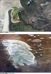
| Description | Two images of the w:Etosha pan in Namibia. The upper view (March 2006) shows the point where the Ekuma River flows into the salt lake; the lower regional image (June 2005) shows the same inlet—but dry—on the north shore of Etosha Pan. Both photos taken from the International Space Station. |
| Date | |
| Source | http://earthobservatory.nasa.gov/Newsroom/NewImages/images.php3?img_id=17261 |
| Auteur | ISS Crew Earth Observations experiment and the Image Science & Analysis Group, Johnson Space Center. Images cropped, cleaned up, and labelled by NASA Earth Observatory. |
| Autorisation (Réutilisation de ce fichier) |
US government, public domain |
| Autres versions | Links to original images available at source URL. |
.jpg)
Conditions d’utilisation
| Ce fichier provient de la NASA. Sauf exception, les documents créés par la NASA ne sont pas soumis à copyright. Pour plus d'informations, voir la politique de copyright de la NASA. | ||
 |
Attention :
|
Historique du fichier
Cliquer sur une date et heure pour voir le fichier tel qu'il était à ce moment-là.
| Date et heure | Vignette | Dimensions | Utilisateur | Commentaire | |
|---|---|---|---|---|---|
| actuel | 1 mai 2006 à 18:07 | | 540 × 782 (103 kio) | Holly Cheng | {{Information | Description=Two images of the w:Etosha pan in Namibia. The upper view (March 2006) shows the point where the Ekuma River flows into the salt lake; the lower regional image (June 2005) shows the same inlet—but dry—on the north shore |
Utilisation du fichier
Les 2 pages suivantes utilisent ce fichier :
Usage global du fichier
Les autres wikis suivants utilisent ce fichier :
- Utilisation sur af.wikipedia.org
- Utilisation sur bg.wikipedia.org
- Utilisation sur ca.wikipedia.org
- Utilisation sur ceb.wikipedia.org
- Utilisation sur en.wikipedia.org
- Utilisation sur eo.wikipedia.org
- Utilisation sur es.wikipedia.org
- Utilisation sur fa.wikipedia.org
- Utilisation sur lb.wikipedia.org
- Utilisation sur pl.wikipedia.org
- Utilisation sur sk.wikipedia.org
- Utilisation sur sl.wikipedia.org
- Utilisation sur www.wikidata.org
- Utilisation sur zh.wikipedia.org