Fichier:Ethnographic map of Epirus, based on P. Aravandinos, 1878.jpg

Fichier d’origine (2 696 × 3 101 pixels, taille du fichier : 2,55 Mio, type MIME : image/jpeg)
Ce fichier et sa description proviennent de Wikimedia Commons.
| Description |
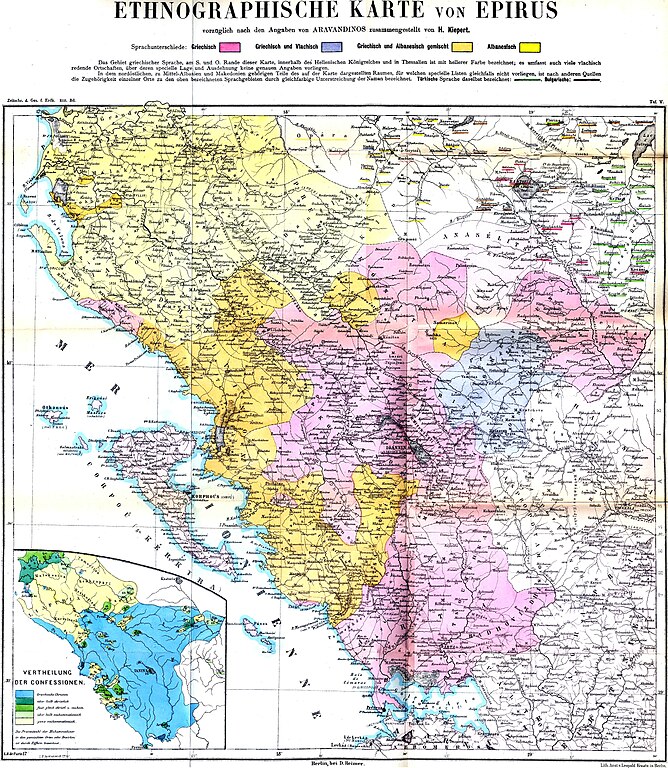
Linguistic (big) and religious (small) map of the Epirus region, 1878. Created by Heinrich Kiepert; data provided by Panagiotis Aravantinos. Greek speakers
Greek and Vlach speakers
Greek and Albanian speakers
Albanian speakers
Greek Orthodox entirely
Greek Orthodox majority
Greek Orthodox – Muslim equivalence
Muslim majority
Muslim entirely |
||||
| Date | |||||
| Source | Zeitschrift der Gesellschaft für Erdkunde | ||||
| Auteur | H.Kiepert, according to the informations delivered by the Greek ethnographer P.Aravandinos | ||||
| Autorisation (Réutilisation de ce fichier) |
|
||||
Historique du fichier
Cliquer sur une date et heure pour voir le fichier tel qu'il était à ce moment-là.
| Date et heure | Vignette | Dimensions | Utilisateur | Commentaire | |
|---|---|---|---|---|---|
| actuel | 8 décembre 2009 à 23:41 | | 2 696 × 3 101 (2,55 Mio) | Alex:D | colors enhanced |
| 11 juin 2009 à 20:04 |  | 2 696 × 3 101 (3,3 Mio) | Olahus | {{Information |Description=Ethnic map of the Epirus region according to the informations delivered by the Greek ethnographer P.Aravandinos |Source=Zeitschrift der Gesellschaft für Erdkunde |Date=1878 |Author=H.Kiepert, according to the informations deliv |
Utilisation du fichier
La page suivante utilise ce fichier :
Usage global du fichier
Les autres wikis suivants utilisent ce fichier :
- Utilisation sur bg.wikipedia.org
- Utilisation sur ca.wikipedia.org
- Utilisation sur cy.wikipedia.org
- Utilisation sur el.wikipedia.org
- Utilisation sur en.wikipedia.org
- Utilisation sur es.wikipedia.org
- Utilisation sur et.wikipedia.org
- Utilisation sur it.wikipedia.org
- Utilisation sur jv.wikipedia.org
- Utilisation sur nl.wikipedia.org
- Utilisation sur pl.wikipedia.org
- Utilisation sur ro.wikipedia.org
- Utilisation sur sh.wikipedia.org
- Utilisation sur sr.wikipedia.org