Fichier:Eros-Topography Map.jpg

Taille de cet aperçu : 800 × 535 pixels. Autres résolutions : 320 × 214 pixels | 640 × 428 pixels | 1 124 × 752 pixels.
Fichier d’origine (1 124 × 752 pixels, taille du fichier : 32 kio, type MIME : image/jpeg)
Ce fichier et sa description proviennent de Wikimedia Commons.
Description
| Description |
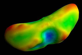
English: From original description: Map of "gravitational topography" of asteroid (433) Eros, painted onto a shape model. Data have been obtained through NEAR Shoemaker mission. Red areas are "uphill" and blue areas are "downhill." A ball dropped onto one of the red spots would try to roll across the nearest green area to the nearest blue area.
Italiano: Mappa tografica di (433) Eros - che tiene conto anche della misura locale della gravità - proiettata su un modello dell'asteroide, ottenuta dai dati della missione Near Earth Asteroid Rendezvous - NEAR NEAR Shoemaker. In rosso le zone più "alte", in blu quelle più "basse". Una palla lasciata cadere in una zona rossa attraverserebbe la più vicina area verde per raggiungere la più vicina area blu. |
| Date | |
| Source | Planetary Photojournal - PIA03111 |
| Auteur | NASA/JPL/JHUAPL |
Conditions d’utilisation
| Ce fichier provient de la NASA. Sauf exception, les documents créés par la NASA ne sont pas soumis à copyright. Pour plus d'informations, voir la politique de copyright de la NASA. | ||
 |
Attention :
|
Historique du fichier
Cliquer sur une date et heure pour voir le fichier tel qu'il était à ce moment-là.
| Date et heure | Vignette | Dimensions | Utilisateur | Commentaire | |
|---|---|---|---|---|---|
| actuel | 29 octobre 2011 à 01:38 | | 1 124 × 752 (32 kio) | Harlock81 | {{Information |Description ={{en|1=From original description: Map of "gravitational topography" of asteroid (433) Eros, painted onto a shape model. Data have been obtained through NEAR Shoemaker mission. Red areas are "uphill" and blue areas are "downh |
Utilisation du fichier
La page suivante utilise ce fichier :
Usage global du fichier
Les autres wikis suivants utilisent ce fichier :
- Utilisation sur ca.wikipedia.org
- Utilisation sur it.wikipedia.org
- Utilisation sur lij.wikipedia.org