Fichier:Dolostone (Knox Dolomite, Upper Cambrian; Warren County core, Ohio, USA) 3.jpg

Fichier d’origine (4 000 × 2 208 pixels, taille du fichier : 4,19 Mio, type MIME : image/jpeg)
Ce fichier et sa description proviennent de Wikimedia Commons.
_3.jpg?uselang=fr)
Description
| Description |
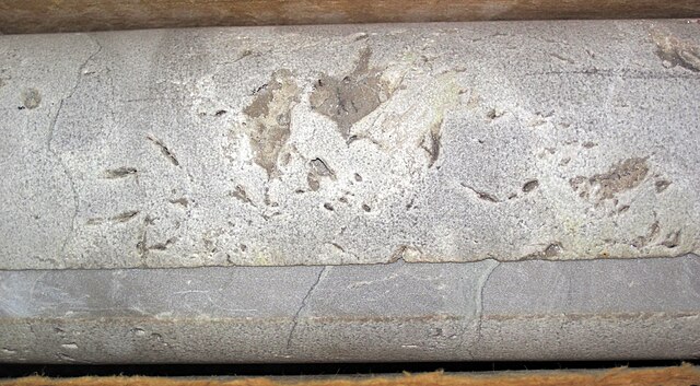
English: Vuggy dolostone from the Cambrian of Ohio, USA.
This is part of a continuously-cored section of Cambrian dolostone from southwestern Ohio's deep subsurface. The Ohio Geological Survey drilled this core from 1987 to 1989 in northeastern Warren County, Ohio. It was intended to be a stratigraphic reference section from the Upper Ordovician to Precambrian basement rocks. Instead of encountering igneous or metamorphic rocks below the Cambrian sedimentary cover, the core unexpectedly penetrated a thick, late Precambrian-aged sedimentary succession, which has been interpreted as a rift-basin fill. The rift fill sedimentary rocks were a new stratigraphic formation now called the Middle Run Formation. The rocks seen here are part of the Knox Dolomite, a thick succession of Cambrian-aged dolostones. In the Warren County core, the Knox is over 300 meters thick. Dolostone is a crystalline-textured chemical sedimentary rock dominated by the mineral dolomite (CaMg(CO3)2 - calcium magnesium carbonate). When powdered, dolomite and dolostone will bubble/fizz/effervesce in acid (such as dilute HCl). The Knox Dolomite is one of several subsurface stratigraphic units in Ohio that occur below the Knox Unconformity, a continent-wide erosion surface. The Knox Unconformity represents significant missing time and is the boundary between the Sauk Megasequence (below) and the Tippecanoe Megasequence (above). In Ohio, the Knox Unconformity is a subtle angular unconformity. In much of Ohio, the Knox Dolomite occurs below the unconformity. in eastern Ohio, the Rose Run Sandstone (Upper Cambrian) occurs below the unconformity. In far-eastern Ohio, inferred Upper Cambrian to Lower Ordovician dolostones of the Beekmantown Dolomite occur below the unconformity. Stratigraphy: Knox Dolomite (= Trempealeau Dolomite; = Copper Ridge Dolomite), Upper Cambrian Locality: 2370 feet to 2380 feet interval (= feet below the surface well site), Ohio Division of Geological Survey core 2627, American Aggregates Corporation limestone quarry (now flooded), just northeast of the town of Lytle, northwestern Wayne Township, northeastern Warren County, southwestern Ohio, USA Core-specific info. from: Shrake (1991) - The Middle Run Formation: a subsurface stratigraphic unit in southwestern Ohio. Ohio Journal of Science 91: 49-55. |
| Date | |
| Source | Travail personnel |
| Auteur | James St. John |
Conditions d’utilisation
- Vous êtes libre :
- de partager – de copier, distribuer et transmettre cette œuvre
- d’adapter – de modifier cette œuvre
- Sous les conditions suivantes :
- paternité – Vous devez donner les informations appropriées concernant l'auteur, fournir un lien vers la licence et indiquer si des modifications ont été faites. Vous pouvez faire cela par tout moyen raisonnable, mais en aucune façon suggérant que l’auteur vous soutient ou approuve l’utilisation que vous en faites.
- partage à l’identique – Si vous modifiez, transformez, ou vous basez sur cette œuvre, vous devez distribuer votre contribution sous la même licence ou une licence compatible avec celle de l’original.
Historique du fichier
Cliquer sur une date et heure pour voir le fichier tel qu'il était à ce moment-là.
| Date et heure | Vignette | Dimensions | Utilisateur | Commentaire | |
|---|---|---|---|---|---|
| actuel | 25 décembre 2018 à 22:05 | | 4 000 × 2 208 (4,19 Mio) | Jsj1771 | User created page with UploadWizard |
Utilisation du fichier
La page suivante utilise ce fichier :
_3.jpg)