Fichier:Danube-Kris-Mures-Tisa Euroregion map.png

Taille de cet aperçu : 509 × 599 pixels. Autres résolutions : 204 × 240 pixels | 408 × 480 pixels | 824 × 970 pixels.
Fichier d’origine (824 × 970 pixels, taille du fichier : 78 kio, type MIME : image/png)
Ce fichier et sa description proviennent de Wikimedia Commons.
Description / Опис
| Description |
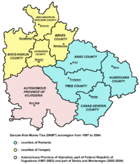
English: map of Danube-Kris-Mures-Tisa (DKMT) euroregion from 1997 to 2004.
Српски / srpski: мапа еурорегиона Дунав-Криш-Мориш-Тиса (ДКМТ) од 1997. до 2004. године. |
| Source | Transféré de en.wikipedia à Commons. |
| Auteur | Original uploader and author was user:PANONIAN at en.wikipedia |
References
- http://www.dkmt.hu/ copie d'archive sur Wayback Machine
- http://geoconfluences.ens-lsh.fr/doc/typespace/frontier/images/BiotMichal6.gif[lien mort]
- http://www.sci.u-szeged.hu/pollinfo/doksik/dkfolyoi.gif
Conditions d’utilisation
self made map by user:PANONIAN
| Cette œuvre a été placée dans le domaine public par son auteur, PANONIAN sur Wikipédia anglais. Ceci s’applique dans le monde entier. Dans certains pays, ceci peut ne pas être possible ; dans ce cas : PANONIAN accorde à toute personne le droit d’utiliser cette œuvre dans n’importe quel but, sans aucune condition, sauf celles requises par la loi. |
-
Journal des téléversements d’origine
La page de description originale était ici. Tous les noms d'utilisateur qui suivent se rapportent à en.wikipedia.
- 14:04, 22 December 2005 (CEST) user:PANONIAN 1083×1005 (531 Kbytes)
Journal des téléversements d’origine
| date/time | username | resolution | size | edit summary | |
|---|---|---|---|---|---|
| 09:54, 2 December 2007 | User:Szajci | <a href="http://upload.wikimedia.org/wikipedia/commons/c/c5/Dkmt.png"><img alt="Thumbnail for version as of 09:54, 2 December 2007" src="http://upload.wikimedia.org/wikipedia/commons/thumb/c/c5/Dkmt.png/120px-Dkmt.png" width="120" height="111" border="0" /></a> | 1,083×1,005 | 531 KB | == Опис == {{Information |Description=map of Danube-Kris-Mures-Tisa euroregion |Source=Originally from [http://en.wikipedia.org en.wikipedia]; description page is/was [http://en.wikipedia.org/w/index.php?title=Image:Dkmt.png here]. |Date= |Author=Orig |
Historique du fichier
Cliquer sur une date et heure pour voir le fichier tel qu'il était à ce moment-là.
| Date et heure | Vignette | Dimensions | Utilisateur | Commentaire | |
|---|---|---|---|---|---|
| actuel | 10 décembre 2011 à 15:32 | | 824 × 970 (78 kio) | PANONIAN | aesthetics |
| 14 décembre 2009 à 17:42 |  | 824 × 970 (78 kio) | PANONIAN | improved version | |
| 13 janvier 2009 à 21:44 |  | 1 083 × 1 005 (531 kio) | BetacommandBot | move approved by: User:Sémhur This image was moved from File:Dkmt.png == Опис == {{Information |Description=map of Danube-Kris-Mures-Tisa euroregion |Source=Originally from [http://en.wikipedia.org en.wikipedia]; description page is/was [h |
Utilisation du fichier
La page suivante utilise ce fichier :
Usage global du fichier
Les autres wikis suivants utilisent ce fichier :
- Utilisation sur be-tarask.wikipedia.org
- Utilisation sur de.wikipedia.org
- Utilisation sur el.wikipedia.org
- Utilisation sur en.wikipedia.org
- Utilisation sur hu.wikipedia.org
- Utilisation sur it.wikipedia.org
- Utilisation sur nl.wikipedia.org
- Utilisation sur ro.wikipedia.org
- Utilisation sur sr.wikipedia.org