Fichier:Daedelus comparison, remote sensing in precision farming.jpg
Taille de cet aperçu : 366 × 598 pixels. Autres résolutions : 147 × 240 pixels | 540 × 883 pixels.
Fichier d’origine (540 × 883 pixels, taille du fichier : 143 kio, type MIME : image/jpeg)
Ce fichier et sa description proviennent de Wikimedia Commons.
| Description |
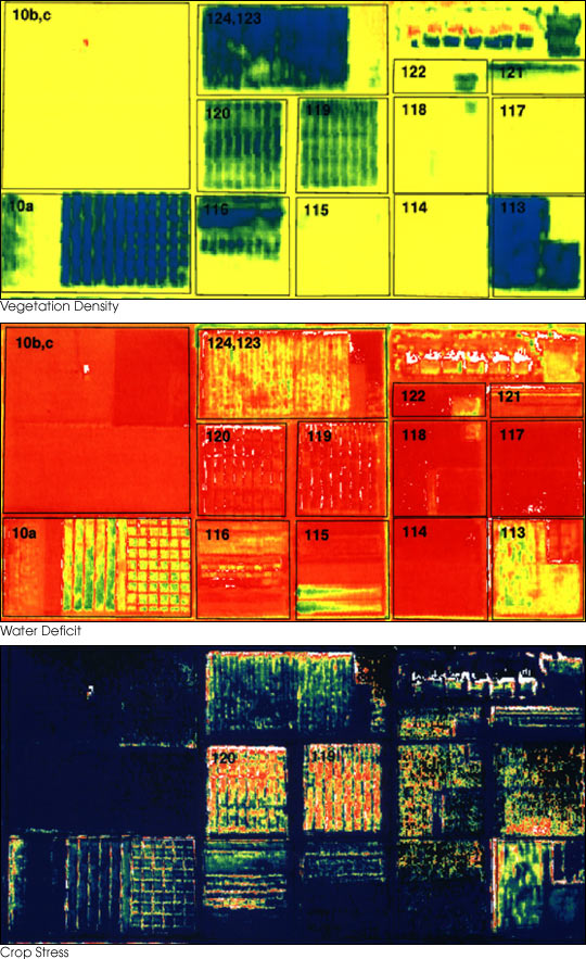
English: These three false-color images demonstrate some of the applications of remote sensing in precision farming. The goal of precision farming is to improve farmers’ profits and harvest yields while reducing the negative impacts of farming on the environment that come from over-application of chemicals. The images were acquired by the Daedalus sensor aboard a NASA aircraft flying over the Maricopa Agricultural Center in Arizona.
|
|||||
| Date | avant 30 janvier 2001 | |||||
| Source | earthobservatory.nasa.gov (NASA Earth Observatory, Image of the Day 2001-01-30 "Precision Farming") | |||||
| Auteur | Susan Moran, Landsat 7 Science Team and USDA Agricultural Research Service (U.S. Government work) | |||||
| Autorisation (Réutilisation de ce fichier) |
|
|||||
| Autres versions |
.jpg) |

Historique du fichier
Cliquer sur une date et heure pour voir le fichier tel qu'il était à ce moment-là.
| Date et heure | Vignette | Dimensions | Utilisateur | Commentaire | |
|---|---|---|---|---|---|
| actuel | 28 juin 2010 à 03:10 | | 540 × 883 (143 kio) | Bdk | {{Information |Description={{en|These three false-color images demonstrate some of the applications of remote sensing in precision farming. The goal of precision farming is to improve farmers’ profits and harvest yields whi |
Utilisation du fichier
Les 2 pages suivantes utilisent ce fichier :
Usage global du fichier
Les autres wikis suivants utilisent ce fichier :
- Utilisation sur ar.wikipedia.org
- Utilisation sur en.wikipedia.org
- Utilisation sur en.wikiversity.org
- Utilisation sur eu.wikipedia.org
- Utilisation sur id.wikipedia.org
- Utilisation sur it.wikipedia.org
- Utilisation sur ja.wikipedia.org
- Utilisation sur ko.wikipedia.org
- Utilisation sur ms.wikipedia.org
- Utilisation sur oc.wikipedia.org
- Utilisation sur ru.wikipedia.org
- Utilisation sur ta.wikipedia.org
- Utilisation sur te.wikipedia.org
- Utilisation sur tr.wikipedia.org
- Utilisation sur uk.wikipedia.org
- Utilisation sur www.wikidata.org