Fichier:Cuba and the Gulf of Batabanó (MODIS).jpg
Taille de cet aperçu : 730 × 599 pixels. Autres résolutions : 292 × 240 pixels | 585 × 480 pixels | 936 × 768 pixels | 1 247 × 1 024 pixels | 2 223 × 1 825 pixels.
Fichier d’origine (2 223 × 1 825 pixels, taille du fichier : 538 kio, type MIME : image/jpeg)
Ce fichier et sa description proviennent de Wikimedia Commons.
.jpg?uselang=fr)
Description
| Description |
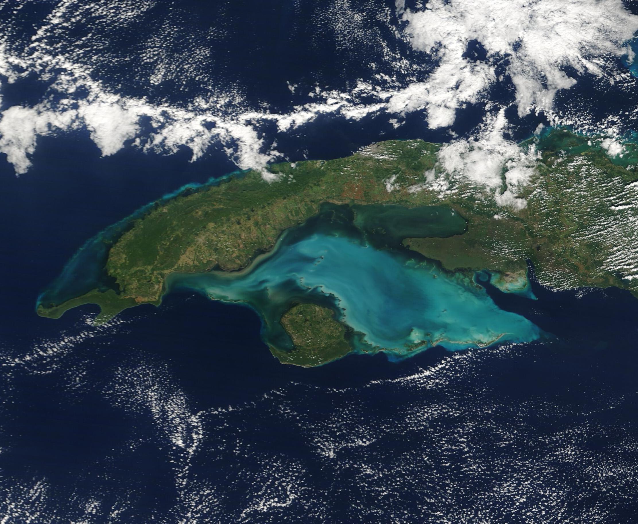
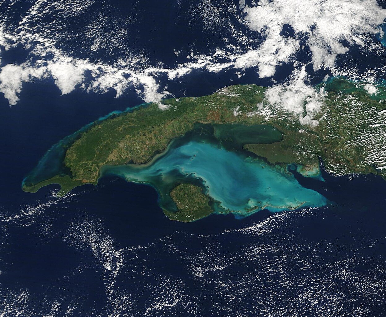
English: The glorious, jewel-toned waters of the Gulf of Batabanó highlight this true-color image of western Cuba which was acquired by the Moderate Resolution Imaging Spectroradiometer (MODIS) on board NASA’s Terra satellite on December 6, 2022.
Cuba is the largest island in the Caribbean, stretching about 750 miles (1,207 km) in length and measuring about 60 miles (97 km) wide on average. A curved shape with numerous peninsulas and inlets brings the island a remarkable 2,300 miles (3,700 km) of coastline. From space, the most outstanding feature associated with Cuba is the Gulf of Batabanó, a shallow inlet of the Caribbean Sea. The Gulf has a surface area of about 20,850 square kilometers (8,050 square miles), which is a slightly larger surface area of the U.S. state of Massachusetts, and an average depth of only 6 meters (19.6 feet). The typically turquoise waters sit over a carbonate bank, and this white, sandy bottom sediment can be easily stirred up by currents, tides, or wind-driven wave action. Wherever carbonate sediment is stirred up, the waters of the Gulf of Batabanó take on a milky tinge, as seen in this image. |
||
| Date | Prise le 6 décembre 2022 | ||
| Source |
Cuba and the Gulf of Batabanó (direct link)
|
||
| Auteur | MODIS Land Rapid Response Team, NASA GSFC |
| This media is a product of the Terra mission Credit and attribution belongs to the mission team, if not already specified in the "author" row |
Conditions d’utilisation
| Ce fichier provient de la NASA. Sauf exception, les documents créés par la NASA ne sont pas soumis à copyright. Pour plus d'informations, voir la politique de copyright de la NASA. | ||
 |
Attention :
|
Historique du fichier
Cliquer sur une date et heure pour voir le fichier tel qu'il était à ce moment-là.
| Date et heure | Vignette | Dimensions | Utilisateur | Commentaire | |
|---|---|---|---|---|---|
| actuel | 15 août 2023 à 14:29 | | 2 223 × 1 825 (538 kio) | OptimusPrimeBot | #Spacemedia - Upload of http://modis.gsfc.nasa.gov/gallery/images/image12082022_250m.jpg via Commons:Spacemedia |
Utilisation du fichier
La page suivante utilise ce fichier :
.jpg)