Fichier:Crew's mess, deck house, forward. From left to right, volunteers Larry Boucher and Maggie Lindley, deckhand Bruce Vanvick, and volunteer Harry Morgan. - Steam Tug HERCULES, HAER CAL,38-SANFRA,201-19.tif

Fichier d’origine (5 000 × 3 614 pixels, taille du fichier : 17,24 Mio, type MIME : image/tiff)
Ce fichier et sa description proviennent de Wikimedia Commons.
Description
| Crew's mess, deck house, forward. From left to right, volunteers Larry Boucher and Maggie Lindley, deckhand Bruce Vanvick, and volunteer Harry Morgan. - Steam Tug HERCULES, Hyde Street Pier, San Francisco, San Francisco County, CA | ||||
|---|---|---|---|---|
| Photographe |
Lowe, Jet Related names:
|
|||
| Titre |
Crew's mess, deck house, forward. From left to right, volunteers Larry Boucher and Maggie Lindley, deckhand Bruce Vanvick, and volunteer Harry Morgan. - Steam Tug HERCULES, Hyde Street Pier, San Francisco, San Francisco County, CA |
|||
| Lieu représenté | California; San Francisco County; San Francisco | |||
| Date | 1988 | |||
| Dimensions | 5 x 7 in. | |||
| Lieu actuel |
Library of Congress Prints and Photographs Division Washington, D.C. 20540 USA http://hdl.loc.gov/loc.pnp/pp.print |
|||
| Numéro d’inventaire |
HAER CAL,38-SANFRA,201-19 |
|||
| Attribution de l’acquisition |
|
|||
| Notes |
At the time of her construction in 1907, HERCULES represented the state of the art in the construction of steam powered tugboats. The vessel currently tied to Hyde Street Pier is little different from when she was launched and stands as a well-preserved model of early twentieth century maritime technology. Beyond her significance as representative of a technological age, HERCULES is important because she and the vessels she towed were a crucial part of the nation's West Coast development.
|
|||
| Références |
|
|||
| Source | https://www.loc.gov/pictures/item/ca1507.photos.041987p | |||
| Autorisation (Réutilisation de ce fichier) |
|
|||

| Position de l'objet | | Voir cet endroit et d’autres images sur : OpenStreetMap |
|---|
Historique du fichier
Cliquer sur une date et heure pour voir le fichier tel qu'il était à ce moment-là.
| Date et heure | Vignette | Dimensions | Utilisateur | Commentaire | |
|---|---|---|---|---|---|
| actuel | 3 juillet 2014 à 16:30 | 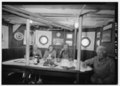 | 5 000 × 3 614 (17,24 Mio) | Fæ | GWToolset: Creating mediafile for Fæ. HABS batch upload 2 July 2014 (301:400) |
Utilisation du fichier
La page suivante utilise ce fichier :
Usage global du fichier
Les autres wikis suivants utilisent ce fichier :
- Utilisation sur en.wikipedia.org