Fichier:Connaught (Knock) Airport - geograph.org.uk - 1011331.jpg
Pas de plus haute résolution disponible.
Connaught_(Knock)_Airport_-_geograph.org.uk_-_1011331.jpg (640 × 418 pixels, taille du fichier : 47 kio, type MIME : image/jpeg)
Ce fichier et sa description proviennent de Wikimedia Commons.
_Airport_-_geograph.org.uk_-_1011331.jpg?uselang=fr)
Description
| Description |
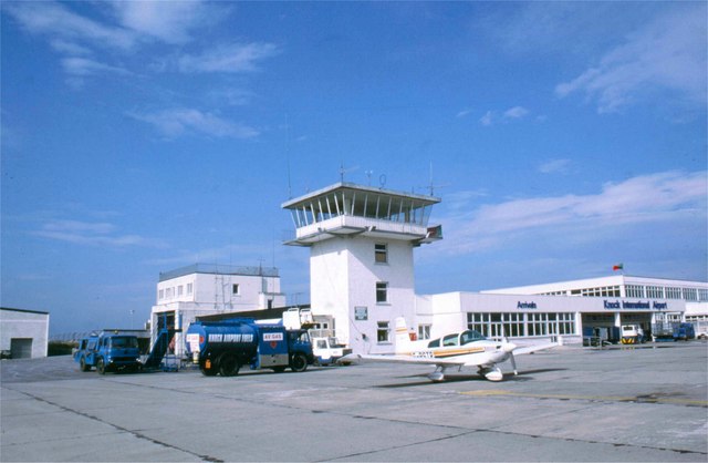
English: Connaught (Knock) Airport A light aircraft parked at the Control Tower of the airport which was built mainly to serve flights bringing visitors to the nearby shrine in Knock. This is a major pilgrimage site in County Mayo where Catholics believe that in 1879 there was an apparition of the Virgin Mary, St Joseph, St John the Evangelist and Jesus Christ (as the Lamb of God).
This large airport was controversially built after Knock's parish priest James Horan persuaded Irish Taoiseach Charles Haughey to release millions of pounds of state aid for its construction. At the time this was condemned by critics in the media. However, the airport now draws not just pilgrims but many other passengers and functions as a useful air-gateway for the entire Connaught region |
| Date | |
| Source | From geograph.org.uk |
| Auteur | James Allan |
| Attribution (imposé par la licence) | James Allan / Connaught (Knock) Airport / |
| Lieu de la prise de vue | | Voir cet endroit et d’autres images sur : OpenStreetMap |
|---|
_Airport_-_geograph.org.uk_-_1011331.jpg¶ms=053.912850_N_-008.814800_E_globe:Earth_type:camera_source:geograph-irishgrid(M46509623)_heading:270.00&language=fr)
| Position de l'objet | | Voir cet endroit et d’autres images sur : OpenStreetMap |
|---|
_Airport_-_geograph.org.uk_-_1011331.jpg¶ms=053.913000_N_-008.817000_E_globe:Earth_class:object_type:object_source:geograph-irishgrid(M463962)_heading:270.00&language=fr)
Conditions d’utilisation

|
Cette image provient de la collection du projet Geograph British Isles. Pour obtenir les coordonnées du photographe, veuillez consulter cette page de description de l'image sur le site du projet. Les droits d'auteurs sur cette image sont détenus par James Allan ; l'image est placée sous une licence Creative Commons avec mention de paternité et partage à l'identique (CC-By-SA) en version 2.0.
|
Ce fichier est disponible selon les termes de la licence Creative Commons Attribution – Partage dans les Mêmes Conditions 2.0 Générique
Attribution: James Allan
- Vous êtes libre :
- de partager – de copier, distribuer et transmettre cette œuvre
- d’adapter – de modifier cette œuvre
- Sous les conditions suivantes :
- paternité – Vous devez donner les informations appropriées concernant l'auteur, fournir un lien vers la licence et indiquer si des modifications ont été faites. Vous pouvez faire cela par tout moyen raisonnable, mais en aucune façon suggérant que l’auteur vous soutient ou approuve l’utilisation que vous en faites.
- partage à l’identique – Si vous modifiez, transformez, ou vous basez sur cette œuvre, vous devez distribuer votre contribution sous la même licence ou une licence compatible avec celle de l’original.
Historique du fichier
Cliquer sur une date et heure pour voir le fichier tel qu'il était à ce moment-là.
| Date et heure | Vignette | Dimensions | Utilisateur | Commentaire | |
|---|---|---|---|---|---|
| actuel | 23 février 2011 à 12:25 | | 640 × 418 (47 kio) | GeographBot | == {{int:filedesc}} == {{Information |description={{en|1=Connaught (Knock) Airport A light aircraft parked at the Control Tower of the airport which was built mainly to serve flights bringing visitors to the nearby shrine in Knock. This is a major pilgrim |
Utilisation du fichier
La page suivante utilise ce fichier :
Usage global du fichier
Les autres wikis suivants utilisent ce fichier :
- Utilisation sur de.wikipedia.org
- Utilisation sur ga.wikipedia.org
- Utilisation sur gl.wikipedia.org
- Utilisation sur it.wikipedia.org
- Utilisation sur nl.wikipedia.org
- Utilisation sur pl.wikipedia.org
_Airport_-_geograph.org.uk_-_1011331.jpg)