Fichier:Churchill river hudson basin map.png
Taille de cet aperçu : 800 × 525 pixels. Autres résolutions : 320 × 210 pixels | 640 × 420 pixels | 1 024 × 672 pixels | 1 200 × 788 pixels.
Fichier d’origine (1 200 × 788 pixels, taille du fichier : 1,6 Mio, type MIME : image/png)
Ce fichier et sa description proviennent de Wikimedia Commons.
Description
| Description |
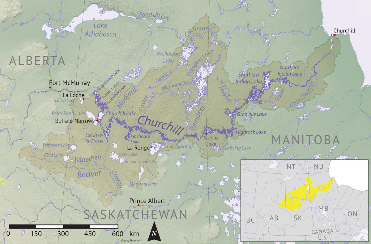
English: Map of the Churchill River (Hudson Bay) drainage basin. Data derived from NASA SRTM, Natural Resources Canada, US Geological Survey, Natural Earth, all public domain. |
| Date | |
| Source | Travail personnel |
| Auteur | Shannon1 |
Conditions d’utilisation
Moi, en tant que détenteur des droits d’auteur sur cette œuvre, je la publie sous les licences suivantes :

|
Vous avez la permission de copier, distribuer et modifier ce document selon les termes de la GNU Free Documentation License version 1.2 ou toute version ultérieure publiée par la Free Software Foundation, sans sections inaltérables, sans texte de première page de couverture et sans texte de dernière page de couverture. Un exemplaire de la licence est inclus dans la section intitulée GNU Free Documentation License. |
This file is licensed under the Creative Commons Attribution-Share Alike 4.0 International, 3.0 Unported, 2.5 Generic, 2.0 Generic and 1.0 Generic license.
- Vous êtes libre :
- de partager – de copier, distribuer et transmettre cette œuvre
- d’adapter – de modifier cette œuvre
- Sous les conditions suivantes :
- paternité – Vous devez donner les informations appropriées concernant l'auteur, fournir un lien vers la licence et indiquer si des modifications ont été faites. Vous pouvez faire cela par tout moyen raisonnable, mais en aucune façon suggérant que l’auteur vous soutient ou approuve l’utilisation que vous en faites.
- partage à l’identique – Si vous modifiez, transformez, ou vous basez sur cette œuvre, vous devez distribuer votre contribution sous la même licence ou une licence compatible avec celle de l’original.
Vous pouvez choisir l’une de ces licences.
Historique du fichier
Cliquer sur une date et heure pour voir le fichier tel qu'il était à ce moment-là.
| Date et heure | Vignette | Dimensions | Utilisateur | Commentaire | |
|---|---|---|---|---|---|
| actuel | 7 novembre 2019 à 06:16 | | 1 200 × 788 (1,6 Mio) | Shannon1 | {{Information |description ={{en|1=Map of the Churchill River (Hudson Bay) drainage basin. Data derived from NASA SRTM, Natural Resources Canada, US Geological Survey, Natural Earth, all public domain.}} |date =2019-11-03 |source =Own work |author =Shannon1 }} Category:Churchill River |
Utilisation du fichier
Les 2 pages suivantes utilisent ce fichier :
Usage global du fichier
Les autres wikis suivants utilisent ce fichier :
- Utilisation sur af.wikipedia.org
- Utilisation sur da.wikipedia.org
- Utilisation sur de.wikipedia.org
- Utilisation sur en.wikipedia.org
- Churchill River (Hudson Bay)
- Beaver River (Canada)
- User:Shannon1/Maps
- Rapid River (Churchill River tributary)
- Montreal River (Saskatchewan)
- Whitefish River (Saskatchewan)
- Waterhen River (Saskatchewan)
- La Loche River (Saskatchewan)
- Geikie River (Saskatchewan)
- Reindeer River (Saskatchewan)
- Cochrane River (Canada)
- Nemei River
- Cold River (Saskatchewan)
- Martineau River
- Rusty Creek
- Meadow River (Saskatchewan)
- Nipekamew River
- Nipekamew Creek
- Big River (Saskatchewan)
- Cowan River
- Bow River (Saskatchewan)
- Waskesiu River
- Makwa River
- MacLennan River
- Smoothstone River
- Utilisation sur ja.wikipedia.org
- Utilisation sur pl.wikipedia.org
- Utilisation sur sh.wikipedia.org
- Utilisation sur uz.wikipedia.org
- Utilisation sur xmf.wikipedia.org
- Utilisation sur zh.wikipedia.org