Fichier:ChiosPrefecture.jpg

Taille de cet aperçu : 800 × 580 pixels. Autres résolutions : 320 × 232 pixels | 640 × 464 pixels | 1 024 × 743 pixels | 1 278 × 927 pixels.
Fichier d’origine (1 278 × 927 pixels, taille du fichier : 109 kio, type MIME : image/jpeg)
Ce fichier et sa description proviennent de Wikimedia Commons.
| Description |
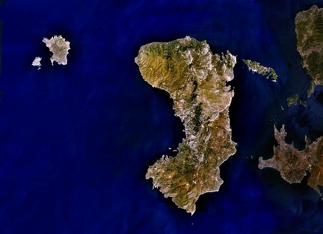
English: Public Domain composite satellite image of Chios Prefecture; consisting of the islands of Chios (centre), of Psara and Anti-Psara (West and far west), the Oinousses islands (East of Chios). Also includes Turkish mainland (East-shaded).
Source: NASA World Wind. In some countries this is not legally possible; if so: |
| Source | Satellite imagery taken from NASA World Wind software (by screenshot) |
| Auteur | Photographie : NASA |
Conditions d’utilisation
| Cette image est dans le domaine public car elle est constituée d'une capture d'écran du logiciel World Wind de la NASA qui utilise des données du domaine public, comme Blue Marble, MODIS, Landsat, SRTM, USGS ou GLOBE.
|
 |
Journal des téléversements d’origine
La page de description originale était ici. Tous les noms d'utilisateur qui suivent se rapportent à en.wikipedia.
- 2007-07-07 19:02 AlekH 1278×927× (111297 bytes) Public Domain composite satellite image of Chios Prefecture; consisting of the islands of Chios (centre), of Psara and Anti-Psara (West and far west), the Oinousses islands (East of Chios). Also includes Turkish mainland (East-shaded). Source: NASA Wor
Historique du fichier
Cliquer sur une date et heure pour voir le fichier tel qu'il était à ce moment-là.
| Date et heure | Vignette | Dimensions | Utilisateur | Commentaire | |
|---|---|---|---|---|---|
| actuel | 4 mai 2009 à 07:22 | | 1 278 × 927 (109 kio) | File Upload Bot (Magnus Manske) | {{BotMoveToCommons|en.wikipedia|year={{subst:CURRENTYEAR}}|month={{subst:CURRENTMONTHNAME}}|day={{subst:CURRENTDAY}}}} {{Information |Description={{en|Public Domain composite satellite image of Chios Prefecture; consisting of the islands of Chios (centre |
Utilisation du fichier
La page suivante utilise ce fichier :
Usage global du fichier
Les autres wikis suivants utilisent ce fichier :
- Utilisation sur arz.wikipedia.org
- Utilisation sur az.wikipedia.org
- Utilisation sur ceb.wikipedia.org
- Utilisation sur cs.wikipedia.org
- Utilisation sur de.wikipedia.org
- Utilisation sur de.wikivoyage.org
- Utilisation sur el.wikipedia.org
- Utilisation sur en.wikipedia.org
- Utilisation sur eo.wikipedia.org
- Utilisation sur es.wikipedia.org
- Utilisation sur gl.wikipedia.org
- Utilisation sur hy.wikipedia.org
- Utilisation sur incubator.wikimedia.org
- Utilisation sur ka.wikipedia.org
- Utilisation sur ko.wikipedia.org
- Utilisation sur lv.wikipedia.org
- Utilisation sur mk.wikipedia.org
- Utilisation sur no.wikipedia.org
- Utilisation sur pl.wiktionary.org
- Utilisation sur ru.wikipedia.org
- Utilisation sur sk.wikipedia.org
- Utilisation sur sl.wikipedia.org
- Utilisation sur sr.wikipedia.org
- Utilisation sur th.wikipedia.org
- Utilisation sur tr.wikipedia.org
- Utilisation sur ur.wikipedia.org
- Utilisation sur www.wikidata.org
- Utilisation sur zh-yue.wikipedia.org
- Utilisation sur zh.wikipedia.org