Fichier:Chesapeake and Ohio Canal National Historical Park (map).jpg

Taille de cet aperçu : 226 × 598 pixels. Autres résolutions : 90 × 240 pixels | 181 × 480 pixels | 290 × 768 pixels | 387 × 1 024 pixels | 774 × 2 048 pixels | 2 740 × 7 248 pixels.
Fichier d’origine (2 740 × 7 248 pixels, taille du fichier : 6,8 Mio, type MIME : image/jpeg)
Ce fichier et sa description proviennent de Wikimedia Commons.
.jpg?uselang=fr)
Description

|
Une version vectorielle de cette image existe, dans le format « SVG ». Si elle n’est pas inférieure, elle devrait être utilisée à la place de la présente version pour des affichages en plus grandes dimensions ou nécessitant une meilleure résolution.
File:Chesapeake and Ohio Canal National Historical Park (map).jpg → File:Chesapeake and Ohio Canal National Historical Park (map).svg
Pour plus d’informations sur les images vectorielles, consultez la page de transition de Commons vers le format SVG. Voir aussi les informations à propos de la manière dont le logiciel MediaWiki gère les images au format SVG. |
.svg) |
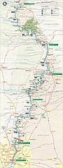
| Description | Map of the Chesapeake and Ohio Canal National Historical Park — along the former Chesapeake and Ohio Canal between Cumberland, Maryland, and Washington, D.C., USA. |
| Date | |
| Source | United States National Park Service, website for Chesapeake and Ohio Canal National Historical Park (http://www.nps.gov/choh/planyourvisit/parkmaps.htm). |
| Auteur | National Park Service, US Department of the Interior. |
| Autorisation (Réutilisation de ce fichier) |
Public domain - original work of the US Federal Government. |
Conditions d’utilisation
| Cette image ou ce document multimédia contiennent des éléments basés sur une œuvre d'un employé du National Park Service, créé dans le cadre des tâches officielles de cette personne. En tant qu'œuvre du Gouvernement fédéral des États-Unis, une telle œuvre se trouve dans le domaine public aux États-Unis. Voir NPS website et NPS copyright policy pour plus d'informations. |
Historique du fichier
Cliquer sur une date et heure pour voir le fichier tel qu'il était à ce moment-là.
| Date et heure | Vignette | Dimensions | Utilisateur | Commentaire | |
|---|---|---|---|---|---|
| actuel | 6 février 2007 à 17:38 | 2 740 × 7 248 (6,8 Mio) | Daderot | {{Information |Description=Map of the Chesapeake and Ohio Canal National Historical Park, along the former Chesapeake and Ohio Canal between Cumberland, Maryland, and Washington, D.C., USA. |Source=United States National Park Service, website for Chesapea |
Utilisation du fichier
La page suivante utilise ce fichier :
Usage global du fichier
Les autres wikis suivants utilisent ce fichier :
- Utilisation sur da.wikipedia.org
- Utilisation sur de.wikipedia.org
- Utilisation sur en.wikipedia.org
- Utilisation sur no.wikipedia.org
- Utilisation sur pl.wikipedia.org
- Utilisation sur zh.wikipedia.org
.jpg)