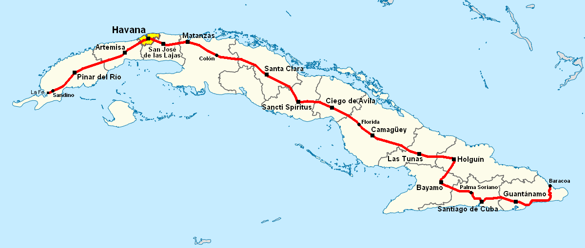
Fichier:Carretera Central map (Cuba).png
Taille de cet aperçu : 800 × 339 pixels. Autres résolutions : 320 × 136 pixels | 640 × 271 pixels | 1 200 × 509 pixels.
Fichier d’origine (1 200 × 509 pixels, taille du fichier : 107 kio, type MIME : image/png)
Ce fichier et sa description proviennent de Wikimedia Commons.
Description
| Description | Note: A file on EcuRed was updated on 15 February 2013 to a new version, based on this file, updated on 31 January 2013. |
| Date | 28 juin 2006 (date de téléversement originale) |
| Source | La source n’a pas pu être reconnue automatiquement. « Travail personnel » supposé (étant donné la revendication de droit d’auteur). |
| Auteur | L’auteur n’a pas pu être identifié automatiquement. Il est supposé qu'il s'agit de : Qyd (étant donné la revendication de droit d’auteur). |
| Autres versions |
|
.png)
.png)
.png)
.png)
.png?uselang=fr)
Conditions d’utilisation
| Moi, propriétaire des droits d’auteur sur cette œuvre, la place dans le domaine public. Ceci s'applique dans le monde entier. Dans certains pays, ceci peut ne pas être possible ; dans ce cas : J’accorde à toute personne le droit d’utiliser cette œuvre dans n’importe quel but, sans aucune condition, sauf celles requises par la loi. |
Historique du fichier
Cliquer sur une date et heure pour voir le fichier tel qu'il était à ce moment-là.
| Date et heure | Vignette | Dimensions | Utilisateur | Commentaire | |
|---|---|---|---|---|---|
| actuel | 16 novembre 2013 à 18:38 | | 1 200 × 509 (107 kio) | DerBorg | little fix (accent to the "A" of Ciego de Ávila) |
| 31 mai 2013 à 21:49 |  | 1 200 × 509 (107 kio) | DerBorg | added Florida (the cuban town) | |
| 4 février 2013 à 04:31 |  | 1 200 × 509 (107 kio) | DerBorg | little fix | |
| 4 février 2013 à 02:28 |  | 1 200 × 509 (107 kio) | DerBorg | little fix (accent to the a of "Guantanamo") | |
| 31 janvier 2013 à 05:12 |  | 1 200 × 509 (107 kio) | DerBorg | little fix | |
| 31 janvier 2013 à 04:57 |  | 1 200 × 509 (107 kio) | DerBorg | Added some fixes to the map: added all the provincial capitals (included the new formed in 2011) crossed by CC, removed San Julian (it's a little village in Sandino municipality, in which starts the road), corrected the Havana-Santa Clara route (in the... | |
| 28 juin 2006 à 07:50 | 1 068 × 409 (154 kio) | Qyd | Map of Carretera Central in Cuba Category:Maps of Cuba |
Utilisation du fichier
La page suivante utilise ce fichier :
Usage global du fichier
Les autres wikis suivants utilisent ce fichier :
- Utilisation sur ca.wikipedia.org
- Utilisation sur de.wikipedia.org
- Utilisation sur en.wikipedia.org
- Utilisation sur eo.wikipedia.org
- Utilisation sur es.wikipedia.org
- Utilisation sur it.wikipedia.org
- Utilisation sur ka.wikipedia.org
- Utilisation sur lt.wikipedia.org
- Utilisation sur nl.wikipedia.org
- Utilisation sur www.wikidata.org
.png)