Fichier:Capital Beltway Map Color.png
Pas de plus haute résolution disponible.
Capital_Beltway_Map_Color.png (562 × 487 pixels, taille du fichier : 66 kio, type MIME : image/png)
Ce fichier et sa description proviennent de Wikimedia Commons.
Description
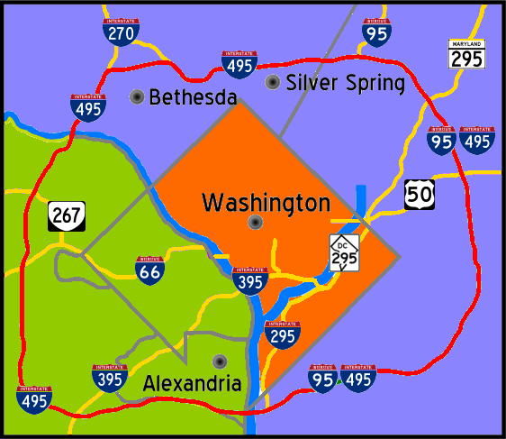
| Description | Interstate 495 in the state of Maryland and Commonwealth of Virgina in red surrounds the District of Columbia like a "belt", hence the name. |
| Date | |
| Source | Travail personnel |
| Auteur | Squiggygfm |

|
Une version vectorielle de cette image existe, dans le format « SVG ». Elle devrait être utilisée à la place de cette image matricielle.
File:Capital Beltway Map Color.png → File:Capital Beltway Map Color.svg
Pour plus d’informations sur les images vectorielles, consultez la page de transition de Commons vers le format SVG. Voir aussi les informations à propos de la manière dont le logiciel MediaWiki gère les images au format SVG. |
 |
Conditions d’utilisation
| Moi, propriétaire des droits d’auteur sur cette œuvre, la place dans le domaine public. Ceci s'applique dans le monde entier. Dans certains pays, ceci peut ne pas être possible ; dans ce cas : J’accorde à toute personne le droit d’utiliser cette œuvre dans n’importe quel but, sans aucune condition, sauf celles requises par la loi. |
Historique du fichier
Cliquer sur une date et heure pour voir le fichier tel qu'il était à ce moment-là.
| Date et heure | Vignette | Dimensions | Utilisateur | Commentaire | |
|---|---|---|---|---|---|
| actuel | 26 avril 2007 à 21:55 | | 562 × 487 (66 kio) | Squiggyfm | {{Information |Description= Interstate 495 in the state of Maryland and Commonwealth of Virgina in red surrounds the District of Columbia like a "belt", hence the name. |Source= |Date= April 26, 2007 |Author= Squiggygfm }} |
Utilisation du fichier
Aucune page n’utilise ce fichier.