Fichier:Cantinomap redsea persiangulf.jpg

Fichier d’origine (666 × 605 pixels, taille du fichier : 318 kio, type MIME : image/jpeg)
Ce fichier et sa description proviennent de Wikimedia Commons.
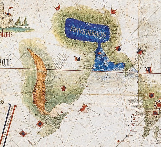
| Description | Enlarged detail showing Red Sea and Persian Gulf as viewed in 1502 in the Cantino World Map. Most important manuscript map surviving from the early Age of Discovery, the Cantino World Map is named for Alberto Cantino, an Italian diplomatic agent in Lisbon who obtained it in 1502 for the Duke of Ferrara. It incorporates extensive new geographical information based on four series of voyages: Columbus to the Caribbean, Pedro Álvarez Cabral to Brazil, Vasco de Gama followed by Cabral to eastern Africa and India, and the brothers Corte-Real to Greenland and Newfoundland. Except for Columbus, all had sailed under the Portuguese flag. |
| Date | (UTC) |
| Source | |
| Auteur |
|
| Cette image a été retouchée, ce qui signifie qu'elle a été modifiée par ordinateur et est différente de l'image d'origine. Liste des modifications : zoom in of Cantino map: the Red sea and Persian Golf. L'image d'origine se trouve ici : CantinoPlanisphere.png:
|
|
Ceci est une reproduction photographique fidèle d'une œuvre d'art originale en deux dimensions. L'œuvre d'art elle-même est dans le domaine public pour la raison suivante :
La position officielle de la Fondation Wikimedia est que « les représentations fidèles des œuvres d'art du domaine public en deux dimensions sont dans le domaine public et les exigences contraires sont une attaque contre le concept même de domaine public ». Pour plus de détails, voir Commons:Quand utiliser le bandeau PD-Art.
Cette reproduction photographique est donc également considérée comme étant élevée dans le domaine public. Merci de noter qu'en fonction des lois locales, la réutilisation de ce contenu peut être interdite ou restreinte dans votre juridiction. Voyez Commons:Reuse of PD-Art photographs. | ||||
Journal des téléversements d’origine
This image is a derivative work of the following images:
- File:CantinoPlanisphere.png licensed with PD-Art, PD-old
- 2007-07-01T05:35:29Z Tdmthomas 3528x1656 (12458523 Bytes) {{Information |Description=The most important manuscript map surviving from the early Age of Discovery, the Cantino World Map is named for Alberto Cantino, an Italian diplomatic agent in Lisbon who obtained it in 1502 for the
Téléversé avec derivativeFX
Historique du fichier
Cliquer sur une date et heure pour voir le fichier tel qu'il était à ce moment-là.
| Date et heure | Vignette | Dimensions | Utilisateur | Commentaire | |
|---|---|---|---|---|---|
| actuel | 12 décembre 2009 à 15:39 | | 666 × 605 (318 kio) | Uxbona | {{Information |Description= Enlarged detail showing Red Sea and Persian Gulf as viewed in 1502 in the Cantino World Map. Most important manuscript map surviving from the early Age of Discovery, the Cantino World Map is named for Alberto Cantino, an Italia |
Utilisation du fichier
La page suivante utilise ce fichier :
Usage global du fichier
Les autres wikis suivants utilisent ce fichier :
- Utilisation sur ar.wikipedia.org
- Utilisation sur ca.wikipedia.org
- Utilisation sur ckb.wikipedia.org
- Utilisation sur de.wikipedia.org
- Utilisation sur el.wikipedia.org
- Utilisation sur en.wikipedia.org
- Utilisation sur es.wikipedia.org
- Utilisation sur fa.wikipedia.org
- Utilisation sur it.wikipedia.org
- Utilisation sur mk.wikipedia.org
- Utilisation sur ms.wikipedia.org
- Utilisation sur pt.wikipedia.org
- Utilisation sur ru.wikipedia.org
- Utilisation sur uk.wikipedia.org
- Utilisation sur yi.wikipedia.org