Fichier:Bulgaria in 1915 geographic map-en.svg

Taille de cet aperçu PNG pour ce fichier SVG : 752 × 600 pixels. Autres résolutions : 301 × 240 pixels | 602 × 480 pixels | 963 × 768 pixels | 1 280 × 1 021 pixels | 2 560 × 2 043 pixels | 2 256 × 1 800 pixels.
Fichier d’origine (Fichier SVG, nominalement de 2 256 × 1 800 pixels, taille : 14,46 Mio)
Ce fichier et sa description proviennent de Wikimedia Commons.
Description
| Description |
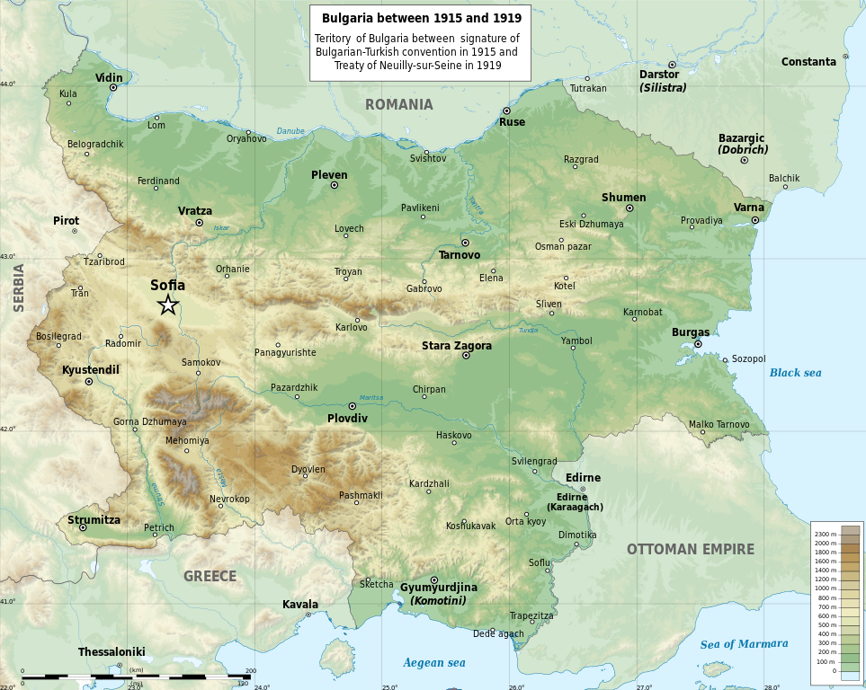
English: Map of Bulgaria in 1915-1919 between the signature of the Bulgarian-Turkish convention in 1915 and the treaty of Neuilly-sur-Seine in 1919 (in English)
Български: Карта на България между 1915 и 1919 г. - след подписването на Българо-турската конвенция през 1915 г. и преди подписването на Ньойския договор през 1919 г. (на английски)
Мар information:
|
| Date | |
| Source |
Travail personnel Data:
|
| Auteur | Ikonact & Пакко |
| Autres versions |
|


|
Ce fichier SVG contient du texte encapsulé pouvant facilement être traduit dans votre langue en utilisant n'importe quel éditeur de fichier SVG ou de texte, ou par l'outil de traduction de fichiers SVG. Pour plus d'informations, voir : A propos de la traduction des fichiers SVG. |
Cette image vectorielle non W3C-spécifiée a été créée avec Inkscape .
W3C-validity not checked.
Conditions d’utilisation
Moi, en tant que détenteur des droits d’auteur sur cette œuvre, je la publie sous les licences suivantes :

|
Vous avez la permission de copier, distribuer et modifier ce document selon les termes de la GNU Free Documentation License version 1.2 ou toute version ultérieure publiée par la Free Software Foundation, sans sections inaltérables, sans texte de première page de couverture et sans texte de dernière page de couverture. Un exemplaire de la licence est inclus dans la section intitulée GNU Free Documentation License. |
This file is licensed under the Creative Commons Attribution-Share Alike 4.0 International, 3.0 Unported, 2.5 Generic, 2.0 Generic and 1.0 Generic license.
- Vous êtes libre :
- de partager – de copier, distribuer et transmettre cette œuvre
- d’adapter – de modifier cette œuvre
- Sous les conditions suivantes :
- paternité – Vous devez donner les informations appropriées concernant l'auteur, fournir un lien vers la licence et indiquer si des modifications ont été faites. Vous pouvez faire cela par tout moyen raisonnable, mais en aucune façon suggérant que l’auteur vous soutient ou approuve l’utilisation que vous en faites.
- partage à l’identique – Si vous modifiez, transformez, ou vous basez sur cette œuvre, vous devez distribuer votre contribution sous la même licence ou une licence compatible avec celle de l’original.
Vous pouvez choisir l’une de ces licences.
Historique du fichier
Cliquer sur une date et heure pour voir le fichier tel qu'il était à ce moment-là.
| Date et heure | Vignette | Dimensions | Utilisateur | Commentaire | |
|---|---|---|---|---|---|
| actuel | 11 janvier 2024 à 22:23 | | 2 256 × 1 800 (14,46 Mio) | Ikonact | correction of border with Turkey |
| 22 juillet 2014 à 22:20 |  | 2 256 × 1 800 (14,48 Mio) | Ikonact | Name of Serbia corrected | |
| 22 juillet 2014 à 22:02 |  | 2 256 × 1 800 (14,48 Mio) | Ikonact | {{Information |Description ={{en|1=Map of Bulgaria in 1915-1919 between the signature of the Bulgarian-Turkish convention in 1915 and the treaty of Neuilly-sur-Seine in 1919 (in English)}} {{bg|1=Карта на България между 1915 и 1... |
Utilisation du fichier
Aucune page n’utilise ce fichier.
Usage global du fichier
Les autres wikis suivants utilisent ce fichier :
- Utilisation sur it.wikipedia.org