Fichier:Bosnia and Hercegovina map without streets.png

Taille de cet aperçu : 477 × 599 pixels. Autres résolutions : 191 × 240 pixels | 382 × 480 pixels | 612 × 768 pixels | 815 × 1 024 pixels | 2 348 × 2 948 pixels.
Fichier d’origine (2 348 × 2 948 pixels, taille du fichier : 1,16 Mio, type MIME : image/png)
Ce fichier et sa description proviennent de Wikimedia Commons.
| Description |
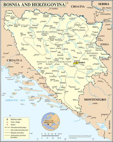
Deutsch: Bosnien und Herzegowina ohne Straßen und Eisenbahnlinien. Ortsnamen entsprechen dem Stand von vor 1993
English: Bosnia and Herzegovina without streets and railways. Names of towns as before 1993 |
| Date | 2 mars 2009 (date de téléversement) |
| Source |
self-made, using
|
| Auteur | NordNordWest |

|
Cette carte a été créée ou améliorée dans le Kartenwerkstatt (Atelier cartographique allemand). Vous pouvez également y proposer des cartes à améliorer.
|
Conditions d’utilisation
| Moi, propriétaire des droits d’auteur sur cette œuvre, la place dans le domaine public. Ceci s'applique dans le monde entier. Dans certains pays, ceci peut ne pas être possible ; dans ce cas : J’accorde à toute personne le droit d’utiliser cette œuvre dans n’importe quel but, sans aucune condition, sauf celles requises par la loi. |
Historique du fichier
Cliquer sur une date et heure pour voir le fichier tel qu'il était à ce moment-là.
| Date et heure | Vignette | Dimensions | Utilisateur | Commentaire | |
|---|---|---|---|---|---|
| actuel | 2 mars 2009 à 14:01 | | 2 348 × 2 948 (1,16 Mio) | NordNordWest | {{Information |Description={{de|Bosnien und Herzegowina ohne Straßen und Eisenbahnlinien}} {{en|Bosnia and Herzegovina without streets and railways}} |Source=self-made, using * file:Bosnia and Hercegovina map.png by The Cartographic Section of the U |
Utilisation du fichier
La page suivante utilise ce fichier :
Usage global du fichier
Les autres wikis suivants utilisent ce fichier :
- Utilisation sur ca.wikipedia.org
- Utilisation sur de.wikipedia.org
- Utilisation sur en.wikipedia.org
- Utilisation sur hy.wikipedia.org
- Utilisation sur ru.wikipedia.org
- Utilisation sur simple.wikipedia.org
- Utilisation sur tr.wikipedia.org
- Utilisation sur uk.wikipedia.org