Fichier:Blank topographic map of the British Isles.svg

Taille de cet aperçu PNG pour ce fichier SVG : 451 × 599 pixels. Autres résolutions : 180 × 240 pixels | 361 × 480 pixels | 578 × 768 pixels | 770 × 1 024 pixels | 1 541 × 2 048 pixels | 1 210 × 1 608 pixels.
Fichier d’origine (Fichier SVG, nominalement de 1 210 × 1 608 pixels, taille : 2,28 Mio)
Ce fichier et sa description proviennent de Wikimedia Commons.
Description
| Description |
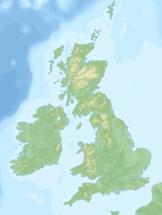
English: Blank topographic map of the British Isles. Equidistant conic projection. Standard parallels: 52°N and 56°N. Central meridian: 4°30'W. Map borders (hidden, larger than shown area): 61°N, 5°E, 49°N, 14°W.
Русский: Бланковая топографическая карта Британских островов. Проекция коническая равнопромежуточная. Стандартные параллели: 52° с.ш. и 56° с.ш. Центральный меридиан: 4°30' з.д. Границы карты (скрыты, шире отображаемой области): 61° с.ш., 5° в.д., 49° с.ш., 14° з.д. |
| Date | |
| Source | Travail personnel |
| Auteur | Hellerick |
Conditions d’utilisation
Moi, en tant que détenteur des droits d’auteur sur cette œuvre, je la publie sous la licence suivante :
Ce fichier est disponible selon les termes de la licence Creative Commons Attribution – Partage dans les Mêmes Conditions 3.0 (non transposée).
- Vous êtes libre :
- de partager – de copier, distribuer et transmettre cette œuvre
- d’adapter – de modifier cette œuvre
- Sous les conditions suivantes :
- paternité – Vous devez donner les informations appropriées concernant l'auteur, fournir un lien vers la licence et indiquer si des modifications ont été faites. Vous pouvez faire cela par tout moyen raisonnable, mais en aucune façon suggérant que l’auteur vous soutient ou approuve l’utilisation que vous en faites.
- partage à l’identique – Si vous modifiez, transformez, ou vous basez sur cette œuvre, vous devez distribuer votre contribution sous la même licence ou une licence compatible avec celle de l’original.
Historique du fichier
Cliquer sur une date et heure pour voir le fichier tel qu'il était à ce moment-là.
| Date et heure | Vignette | Dimensions | Utilisateur | Commentaire | |
|---|---|---|---|---|---|
| actuel | 8 novembre 2013 à 02:37 | | 1 210 × 1 608 (2,28 Mio) | Hellerick | Minor isohypse fixes. |
| 7 novembre 2013 à 10:50 |  | 1 210 × 1 608 (2,28 Mio) | Hellerick | + Bathymetry | |
| 6 novembre 2013 à 10:40 |  | 1 210 × 1 608 (1,73 Mio) | Hellerick | User created page with UploadWizard |
Utilisation du fichier
Aucune page n’utilise ce fichier.
Usage global du fichier
Les autres wikis suivants utilisent ce fichier :
- Utilisation sur stq.wikipedia.org