Fichier:Bevölkerungsprognosen Blankenfelde-Mahlow.pdf
Taille de cet aperçu JPG pour ce fichier PDF : 800 × 566 pixels. Autres résolutions : 320 × 226 pixels | 640 × 453 pixels | 1 024 × 724 pixels | 1 280 × 905 pixels | 1 752 × 1 239 pixels.
Fichier d’origine (1 752 × 1 239 pixels, taille du fichier : 70 kio, type MIME : application/pdf)
Ce fichier et sa description proviennent de Wikimedia Commons.
Description
| Description |
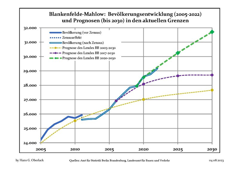
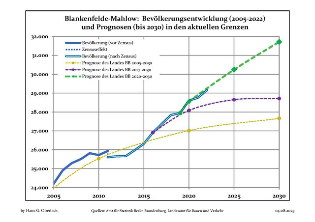
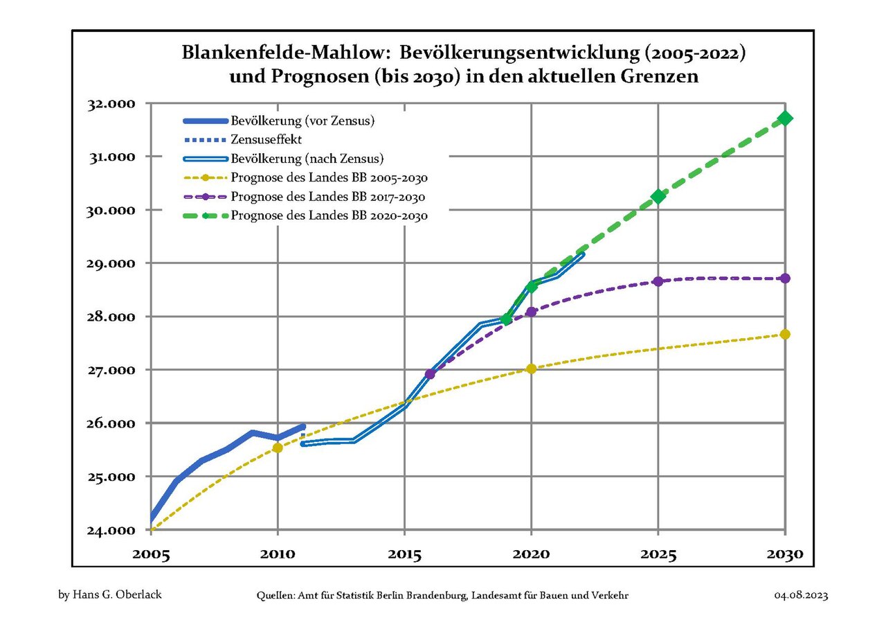
Deutsch: Aktuelle Bevölkerungsentwicklung (blaue Linien) und Prognosen (punktierte Linien) für Blankenfelde-Mahlow , Landkreis Teltow-Fläming, Land Brandenburg, Deutschland
English: Recent population development (blue lines) and projections (dotted lines) of Blankenfelde-Mahlow, Teltow-Fläming district, Brandenburg state, Germany
Español: Tendencias actuales (lineas azules) y previsiones (lineas de puntos) de la poblacion de Blankenfelde-Mahlow, distrito de Teltow-Fläming, estado de Brandenburg, Alemania
Français : Évolution actuelle de la population (lignes bleues) et projections démographiques (lignes pointillées) de Blankenfelde-Mahlow, arrondissement de Teltow-Fläming, Land de Brandebourg, Allemagne
Italiano: Sviluppo recente della popolazione (linea blu) e previsioni demografiche (linee puntinate) di Blankenfelde-Mahlow, circondario di Teltow-Fläming, stato federato de Brandeburgo, Germania
Nederlands: Recente ontwikkeling van de bevolking (blauwe lijn) en prognoses (stippelijn) van Blankenfelde-Mahlow, landkreis Teltow-Fläming, deelstaat Brandenburg, Duitsland
Polski: Obecne tendencje (niebieska linia) i prognozy demograficzne (linia przerywana) dla Blankenfelde-Mahlow, powiat Teltow-Fläming, kraj Brandenburgia, Niemcy
Svenska: Aktuella befolkningsutveckling (blå linjen) och prognoser (prickade linjen) av Blankenfelde-Mahlow, landkreis Teltow-Fläming, delstaten Brandenburg, Tyskland |
| Date | entre le 28 avril 2012 et le 4 août 2023 |
| Source | Travail personnel basé sur : Data sources displayed at Population Projection Brandenburg at Wikimedia Commons |
| Auteur | Hans G. Oberlack |
| Latest population data | 2022 |
| Latest population forecast | LBV 2020-2030 |
| Type og municipality | amtsfrei |
| Position de l'objet | | Voir cet endroit et d’autres images sur : OpenStreetMap |
|---|
Conditions d’utilisation
Moi, en tant que détenteur des droits d’auteur sur cette œuvre, je la publie sous la licence suivante :
Ce fichier est disponible selon les termes de la licence Creative Commons Attribution – Partage dans les Mêmes Conditions 3.0 (non transposée).
- Vous êtes libre :
- de partager – de copier, distribuer et transmettre cette œuvre
- d’adapter – de modifier cette œuvre
- Sous les conditions suivantes :
- paternité – Vous devez donner les informations appropriées concernant l'auteur, fournir un lien vers la licence et indiquer si des modifications ont été faites. Vous pouvez faire cela par tout moyen raisonnable, mais en aucune façon suggérant que l’auteur vous soutient ou approuve l’utilisation que vous en faites.
- partage à l’identique – Si vous modifiez, transformez, ou vous basez sur cette œuvre, vous devez distribuer votre contribution sous la même licence ou une licence compatible avec celle de l’original.
Historique du fichier
Cliquer sur une date et heure pour voir le fichier tel qu'il était à ce moment-là.
| Date et heure | Vignette | Dimensions | Utilisateur | Commentaire | |
|---|---|---|---|---|---|
| actuel | 4 août 2023 à 20:22 |  | 1 752 × 1 239 (70 kio) | Hans G. Oberlack | 2022 data added |
| 14 août 2022 à 12:59 |  | 1 752 × 1 239 (127 kio) | Hans G. Oberlack | 2021 data added | |
| 1 octobre 2021 à 23:36 | 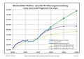 | 1 752 × 1 239 (126 kio) | Hans G. Oberlack | New official forecast and 2020 data added | |
| 23 août 2020 à 00:07 | Aucune vignette | 0 × 0 (126 kio) | Hans G. Oberlack | 2019 data added | |
| 5 août 2019 à 00:18 | Aucune vignette | 0 × 0 (140 kio) | Hans G. Oberlack | 2018 data added | |
| 11 mars 2019 à 00:51 | Aucune vignette | 0 × 0 (126 kio) | Hans G. Oberlack | Latest official forecast added | |
| 3 octobre 2018 à 23:20 | Aucune vignette | 0 × 0 (121 kio) | Hans G. Oberlack | 2017 data added | |
| 20 janvier 2018 à 17:15 | Aucune vignette | 0 × 0 (120 kio) | Hans G. Oberlack | Latest official forecast and 2014, 2015 and 2016 data added | |
| 29 octobre 2014 à 16:28 | Aucune vignette | 0 × 0 (97 kio) | Hans G. Oberlack | 2013 data added | |
| 6 septembre 2013 à 21:51 | Aucune vignette | 0 × 0 (97 kio) | Hans G. Oberlack | Census and 2012 data added |
Utilisation du fichier
La page suivante utilise ce fichier :
Usage global du fichier
Les autres wikis suivants utilisent ce fichier :
- Utilisation sur en.wikipedia.org
- Utilisation sur es.wikipedia.org
- Utilisation sur fa.wikipedia.org
- Utilisation sur it.wikipedia.org
- Utilisation sur nl.wikipedia.org
- Utilisation sur sv.wikipedia.org
- Utilisation sur uk.wikipedia.org