Fichier:Belgrád - 38-45.jpg

Taille de cet aperçu : 435 × 600 pixels. Autres résolutions : 174 × 240 pixels | 348 × 480 pixels | 557 × 768 pixels | 742 × 1 024 pixels | 1 485 × 2 048 pixels | 3 591 × 4 952 pixels.
Fichier d’origine (3 591 × 4 952 pixels, taille du fichier : 4,36 Mio, type MIME : image/jpeg)
Ce fichier et sa description proviennent de Wikimedia Commons.
|
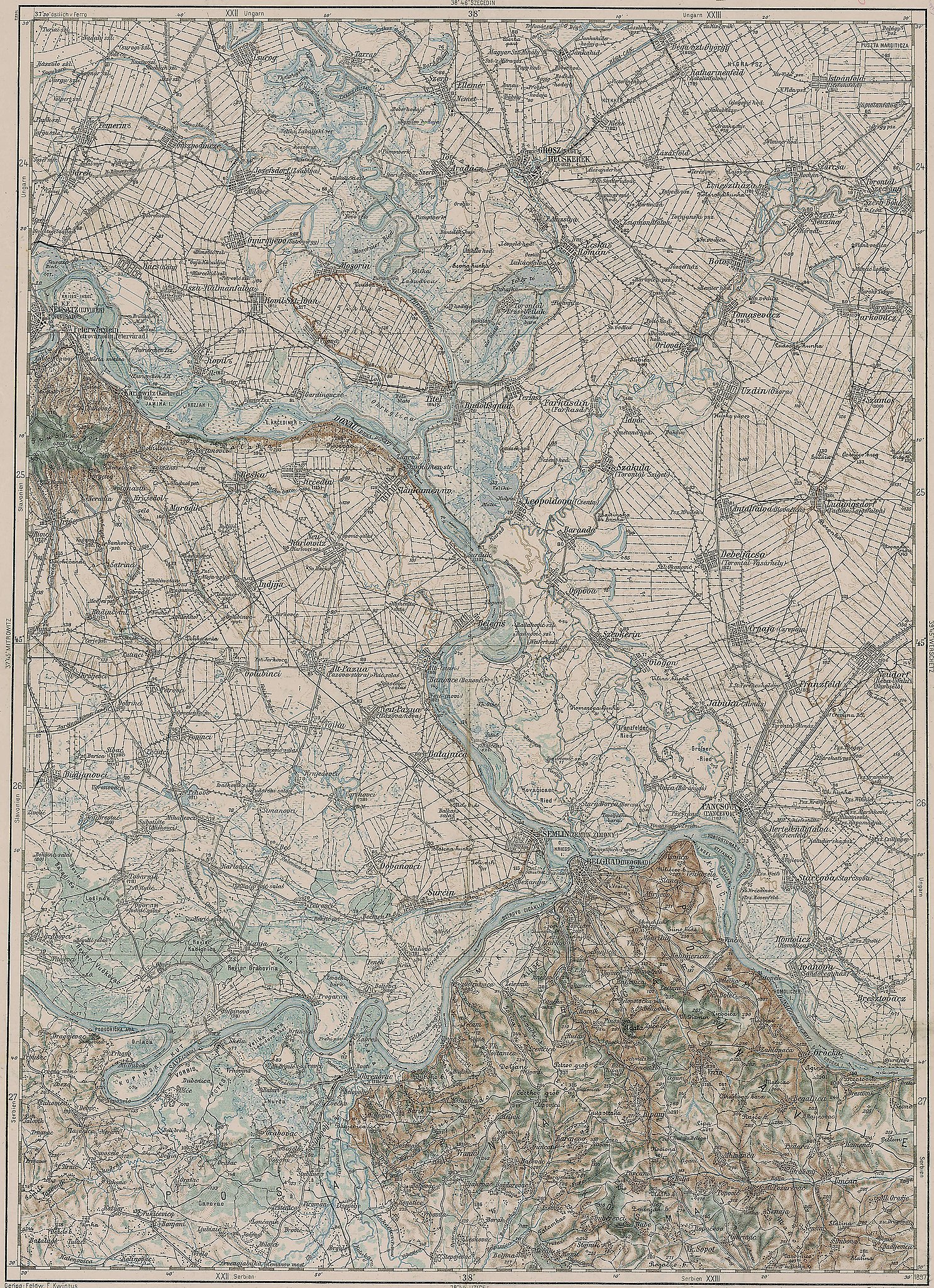
Deutsch: Blatt 38-45 der Generalkarte von Mitteleuropa 1:200.000 der Franzisco-Josephinischen Landesaufnahme, Österreich-Ungarn, ab 1887. Die Blattmitte liegt bei 45° n.Br. und 38° ö.L. (östlich von Ferro, nicht Greenwich!). English: Sheet 38-45 of the General Map of Central Europe, scale 1:200,000, edited 1887 ff. See 3rd Military Mapping Survey of Austria-Hungary for details. The center of the sheet is 45° North, 38° East (east of Ferro, not Greenwich!).
← Nachbarblätter. Klicken Sie auf eine Miniatur, um zu diesem Blatt zu gelangen.
← Neighbouring sheets. Click thumbnail to navigate |


.jpg)
Description
| Description | 3rd Military Mapping Survey of Austria-Hungary - Belgrád |
| Date | vers 1910 |
| Source | http://lazarus.elte.hu/hun/moterkep.htm - László ZENTAI |
| Auteur | Military mapping authority of Austria-Hungary |
| Autres versions |
.jpg)
Conditions d’utilisation
|
Cette œuvre est également dans le domaine public dans tous les pays pour lesquels le droit d’auteur a une durée de vie de 100 ans ou moins après la mort de l’auteur. Cette œuvre est dans le domaine public aux États-Unis car elle a été publiée avant le 1er janvier 1929. | |
| Ce fichier a été identifié comme étant exempt de restrictions connues liées au droit d’auteur, y compris tous les droits connexes et voisins. | |
Historique du fichier
Cliquer sur une date et heure pour voir le fichier tel qu'il était à ce moment-là.
| Date et heure | Vignette | Dimensions | Utilisateur | Commentaire | |
|---|---|---|---|---|---|
| actuel | 21 mars 2007 à 09:32 | | 3 591 × 4 952 (4,36 Mio) | Szilas | == Összefoglaló == 3rd Military Mapping Survey of Austria-Hungary - Belgrád Source: http://lazarus.elte.hu/hun/moterkep.htm - László ZENTAI Category:3rd Military Mapping Survey of Austria-Hungary == Licensing == {{PD-old}} |
Utilisation du fichier
La page suivante utilise ce fichier :
Usage global du fichier
Les autres wikis suivants utilisent ce fichier :
- Utilisation sur de.wikipedia.org
- Utilisation sur en.wikipedia.org
- Utilisation sur hu.wikipedia.org
- Utilisation sur hu.wikibooks.org
- Utilisation sur sr.wikipedia.org