Fichier:BART-WS-extension-map.png
Pas de plus haute résolution disponible.
BART-WS-extension-map.png (521 × 537 pixels, taille du fichier : 85 kio, type MIME : image/png)
Ce fichier et sa description proviennent de Wikimedia Commons.
Description

|
Une version vectorielle de cette image existe, dans le format « SVG ». Si elle n’est pas inférieure, elle devrait être utilisée à la place de la présente version pour des affichages en plus grandes dimensions ou nécessitant une meilleure résolution.
File:BART-WS-extension-map.png → File:BART WSX overlay.svg
Pour plus d’informations sur les images vectorielles, consultez la page de transition de Commons vers le format SVG. Voir aussi les informations à propos de la manière dont le logiciel MediaWiki gère les images au format SVG. |
 |
| Description |
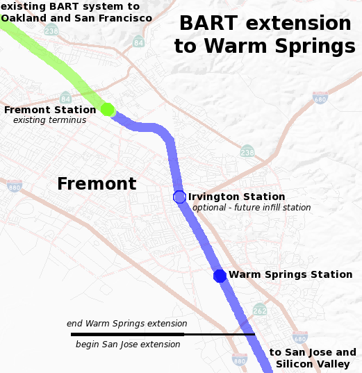
English: Map of the planned Bay Area Rapid Transit extension to Warm Springs. The background map of Fremont was generated by the USGS National Map. The route and plans are based on data from BART including the Warm Springs project alignment description. |
| Date | |
| Source | Travail personnel |
| Auteur | Ikluft |
Conditions d’utilisation
Moi, en tant que détenteur des droits d’auteur sur cette œuvre, je la publie sous la licence suivante :
Ce fichier est disponible selon les termes de la licence Creative Commons Attribution – Partage dans les Mêmes Conditions 3.0 (non transposée).
- Vous êtes libre :
- de partager – de copier, distribuer et transmettre cette œuvre
- d’adapter – de modifier cette œuvre
- Sous les conditions suivantes :
- paternité – Vous devez donner les informations appropriées concernant l'auteur, fournir un lien vers la licence et indiquer si des modifications ont été faites. Vous pouvez faire cela par tout moyen raisonnable, mais en aucune façon suggérant que l’auteur vous soutient ou approuve l’utilisation que vous en faites.
- partage à l’identique – Si vous modifiez, transformez, ou vous basez sur cette œuvre, vous devez distribuer votre contribution sous la même licence ou une licence compatible avec celle de l’original.
Historique du fichier
Cliquer sur une date et heure pour voir le fichier tel qu'il était à ce moment-là.
| Date et heure | Vignette | Dimensions | Utilisateur | Commentaire | |
|---|---|---|---|---|---|
| actuel | 2 janvier 2017 à 23:42 | | 521 × 537 (85 kio) | Jeanjung212 | Lossless Compressed/optimized png decreasing file size by 48050 bytes |
| 14 décembre 2008 à 02:52 |  | 521 × 537 (132 kio) | Ikluft | major cleanup - add mid-background layer with highways and highway shields | |
| 7 décembre 2008 à 13:19 |  | 521 × 537 (180 kio) | Ikluft | {{Information |Description={{en|1=Map of the planned Bay Area Rapid Transit extension to Warm Springs. The background map of Fremont was generated by the [http://www.nationalmap.gov/ USGS National Map]. The route and plans are |
Utilisation du fichier
Aucune page n’utilise ce fichier.
Usage global du fichier
Les autres wikis suivants utilisent ce fichier :
- Utilisation sur en.wikipedia.org
- Utilisation sur nl.wikipedia.org