Fichier:Azores satellite photo-NASA.jpg

Taille de cet aperçu : 800 × 600 pixels. Autres résolutions : 320 × 240 pixels | 640 × 480 pixels | 1 024 × 768 pixels | 1 280 × 960 pixels | 1 600 × 1 200 pixels.
Fichier d’origine (1 600 × 1 200 pixels, taille du fichier : 99 kio, type MIME : image/jpeg)
Ce fichier et sa description proviennent de Wikimedia Commons.
Description
| Description |
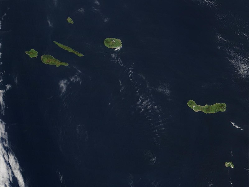
Deutsch: Satellitenfoto der Azoren
English: Original caption: Hundreds of miles off the coast of Portugal, the nine islands of the Azores chains are stretched out over the Atlantic Ocean. This Moderate Resolution Imaging Spectroradiometer (MODIS) image from the Terra satellite on May 1, 2003, shows seven of the nine islands: (from left to right) Faial, Pico, Sao Jorge, Graciosa (north), Terceira, Sao Miguel, and Santa Maria. |
| Date | |
| Source | visibleearth.nasa.gov (VE Record ID: 25535) |
| Auteur | Jeff Schmaltz, MODIS Rapid Response Team, NASA/GSFC |
| Autres versions | cropped and annotated version: File:Satellite image of The Azores in May 2003.jpg |
Conditions d’utilisation
| Ce fichier provient de la NASA. Sauf exception, les documents créés par la NASA ne sont pas soumis à copyright. Pour plus d'informations, voir la politique de copyright de la NASA. | ||
 |
Attention :
|
Historique du fichier
Cliquer sur une date et heure pour voir le fichier tel qu'il était à ce moment-là.
| Date et heure | Vignette | Dimensions | Utilisateur | Commentaire | |
|---|---|---|---|---|---|
| actuel | 20 mai 2007 à 11:28 | | 1 600 × 1 200 (99 kio) | Yonidebest | {{Information |Description='''Original caption:''' :''Hundreds of miles off the coast of Portugal, the nine islands of the Azores chains are stretched out over the Atlantic Ocean. This Moderate Resolution Imaging Spectroradiometer (MODIS) image from the T |
Utilisation du fichier
Aucune page n’utilise ce fichier.
Usage global du fichier
Les autres wikis suivants utilisent ce fichier :
- Utilisation sur an.wikipedia.org
- Utilisation sur ast.wikipedia.org
- Utilisation sur en.wiktionary.org
- Utilisation sur eo.wikipedia.org
- Utilisation sur es.wikipedia.org
- Utilisation sur eu.wikipedia.org
- Utilisation sur gl.wikipedia.org
- Utilisation sur la.wikipedia.org
- Utilisation sur lij.wikipedia.org
- Utilisation sur li.wikipedia.org
- Utilisation sur mwl.wikipedia.org
- Utilisation sur nl.wikipedia.org
- Utilisation sur oc.wikipedia.org
- Utilisation sur pl.wiktionary.org
- Utilisation sur pt.wikipedia.org
- Utilisation sur sv.wikipedia.org
- Utilisation sur www.wikidata.org
- Utilisation sur zea.wikipedia.org