Fichier:Asker Line map.jpg
Taille de cet aperçu : 800 × 512 pixels. Autres résolutions : 320 × 205 pixels | 640 × 410 pixels | 898 × 575 pixels.
Fichier d’origine (898 × 575 pixels, taille du fichier : 129 kio, type MIME : image/jpeg)
Ce fichier et sa description proviennent de Wikimedia Commons.
| Description |
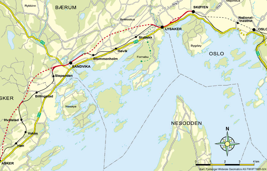
English: Map of the Asker Line west of Oslo, Norway. Red line is the Asker Line and black line is the Drammen Line. Dotted lines are tunnels. Black dots are stations. The green line is the Fornebu Line. The yellow lines indicate European Routes E16 and E18. |
|||
| Source | http://www.jernbaneverket.no/multimedia/archive/01417/Kart_Sk_yen-Asker_1417793a.jpg | |||
| Auteur | Jernbaneverket / Norwegian National Rail Administration | |||
| Autorisation (Réutilisation de ce fichier) |
|


|
Cette image (de type carte) devrait être recréée dans un format vectoriel, en tant que fichier SVG. Cela offrirait plusieurs avantages : voir Commons:Media for cleanup pour plus d'informations. Si une version SVG de cette image est déjà disponible, merci de bien vouloir l'envoyer. Après cela, remplacez ce modèle par {{vector version available|nouveau nom d'image.svg}}.
|


Historique du fichier
Cliquer sur une date et heure pour voir le fichier tel qu'il était à ce moment-là.
| Date et heure | Vignette | Dimensions | Utilisateur | Commentaire | |
|---|---|---|---|---|---|
| actuel | 7 mai 2020 à 12:56 | | 898 × 575 (129 kio) | Tholme | Cropped 3 % horizontally, 5 % vertically using CropTool with lossless mode. Remove border |
| 18 novembre 2008 à 20:58 |  | 926 × 603 (136 kio) | Arsenikk | {{Information |Description={{en|1=Map of the Asker Line west of Oslo, Norway. Red line is the Asker Line and black line is the Drammen Line. Dotted lines are tunnels. Black dots are stati |
Utilisation du fichier
La page suivante utilise ce fichier :
Usage global du fichier
Les autres wikis suivants utilisent ce fichier :
- Utilisation sur da.wikipedia.org
- Utilisation sur de.wikipedia.org
- Utilisation sur en.wikipedia.org
- Utilisation sur id.wikipedia.org
- Utilisation sur nl.wikipedia.org
- Utilisation sur nn.wikipedia.org
- Utilisation sur no.wikipedia.org
- Utilisation sur pl.wikipedia.org
- Utilisation sur sv.wikipedia.org
- Utilisation sur www.wikidata.org