Fichier:Arthur 2008 track.png

Taille de cet aperçu : 800 × 495 pixels. Autres résolutions : 320 × 198 pixels | 640 × 396 pixels | 1 024 × 633 pixels | 1 280 × 791 pixels | 2 700 × 1 669 pixels.
Fichier d’origine (2 700 × 1 669 pixels, taille du fichier : 2,92 Mio, type MIME : image/png)
Ce fichier et sa description proviennent de Wikimedia Commons.
Description
| Description |
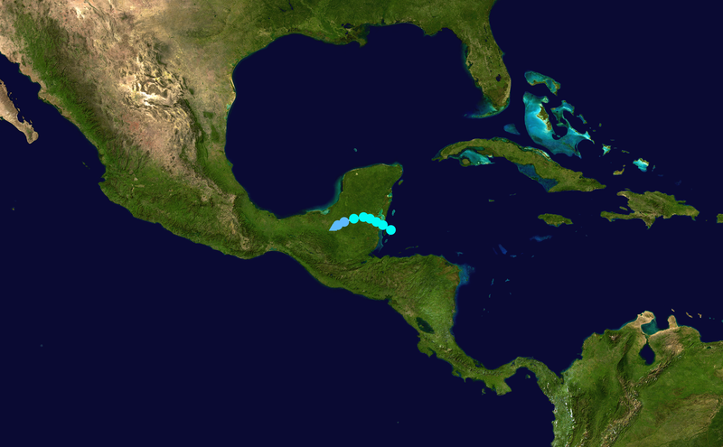
English: Track map of Tropical Storm Arthur of the 2008 Atlantic hurricane season. The points show the location of the storm at 6-hour intervals. The colour represents the storm's maximum sustained wind speeds as classified in the (see below), and the shape of the data points represent the nature of the storm, according to the legend below. Tropical depression (≤38 mph, ≤62 km/h)
Tropical storm (39–73 mph, 63–118 km/h)
Category 1 (74–95 mph, 119–153 km/h)
Category 2 (96–110 mph, 154–177 km/h)
Category 3 (111–129 mph, 178–208 km/h)
Category 4 (130–156 mph, 209–251 km/h)
Category 5 (≥157 mph, ≥252 km/h)
Unknown
Storm type |
||
| Date | 2008-05-31–2008-06-02 | ||
| Source | Created by Supportstorm using Wikipedia:WikiProject Tropical cyclones/Tracks. The background image is from NASA. Tracking data is from the National Hurricane Center[1]. | ||
| Auteur | Supportstorm | ||
| Source code | Track map data table, if present below, is in HURDAT2 or ATCF format. See format details in [2] and [3], respectively.
|
Conditions d’utilisation
| Cette œuvre a été placée dans le domaine public par son auteur, Supportstorm. Ceci s’applique dans le monde entier. Dans certains pays, ceci peut ne pas être possible ; dans ce cas : Supportstorm accorde à toute personne le droit d’utiliser cette œuvre dans n’importe quel but, sans aucune condition, sauf celles requises par la loi. |
Historique du fichier
Cliquer sur une date et heure pour voir le fichier tel qu'il était à ce moment-là.
| Date et heure | Vignette | Dimensions | Utilisateur | Commentaire | |
|---|---|---|---|---|---|
| actuel | 18 août 2019 à 09:32 | | 2 700 × 1 669 (2,92 Mio) | Supportstorm | Correction from HURDAT |
| 13 mars 2009 à 22:58 |  | 1 024 × 633 (477 kio) | Potapych | fix a slight error | |
| 18 décembre 2008 à 00:54 |  | 1 024 × 633 (497 kio) | Potapych | generated with track program | |
| 30 juillet 2008 à 03:06 |  | 707 × 397 (261 kio) | CWY2190 | New image with smaller shapes. | |
| 30 juillet 2008 à 02:39 |  | 800 × 487 (334 kio) | CWY2190 | Arthur best track | |
| 10 juillet 2008 à 01:05 |  | 1 000 × 629 (457 kio) | CWY2190 | adding four low pressure areas | |
| 10 juillet 2008 à 00:30 |  | 1 000 × 629 (457 kio) | CWY2190 | Track map of Tropical Storm Arthur of the 2008 Atlantic hurricane season. The background image is from {{w|NASA}}. Tracking data is from the [ftp://ftp.tpc.ncep.noaa.gov/atcf/tcweb/invest_al012008.invest|Natio | |
| 10 juillet 2008 à 00:30 |  | 1 000 × 629 (457 kio) | CWY2190 | Track map of Tropical Storm Arthur of the 2008 Atlantic hurricane season. The background image is from {{w|NASA}}. Tracking data is from the [ftp://ftp.tpc.ncep.noaa.gov/atcf/tcweb/invest_al012008.invest|Natio | |
| 2 juin 2008 à 20:43 |  | 1 024 × 636 (25 kio) | Ramisses | {{Information |Description={{en|1=Tropical Storm Arthur (2008) track map}} |Source=Own work by uploader |Author=Ramisses |Date=2008-06-02 |Permission={{PD-self}} |other_versions= }} {{ImageUpload|full}} [[Category:Tropical Storm Arthur |
Utilisation du fichier
La page suivante utilise ce fichier :
Usage global du fichier
Les autres wikis suivants utilisent ce fichier :
- Utilisation sur cs.wikipedia.org
- Utilisation sur de.wikipedia.org
- Utilisation sur en.wikipedia.org
- Utilisation sur es.wikipedia.org
- Utilisation sur eu.wikipedia.org
- Utilisation sur ko.wikipedia.org
- Utilisation sur nl.wikipedia.org
- Utilisation sur no.wikipedia.org
- Utilisation sur pt.wikipedia.org
- Utilisation sur ru.wikipedia.org
- Utilisation sur simple.wikipedia.org
- Utilisation sur sv.wikipedia.org
- Utilisation sur uk.wikipedia.org
- Utilisation sur www.wikidata.org
- Utilisation sur zh.wikipedia.org