Fichier:Archaeological geography of Vale Royal Abbey, Cheshire.svg

Fichier d’origine(Fichier SVG, nominalement de 1 081 × 949 pixels, taille : 55 kio)

Ce fichier et sa description proviennent de Wikimedia Commons.

Description

Description
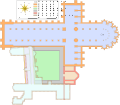
English: Foundations of Vale Royal Abbey and its outbuildings as excavated in 1911, 1958 and 1988, indicating its proximity to the modern-day building built on Abbey land in the 16th century.
institution QS:P195,Q1623747
Date
Source

Travail personnel
Derived from;

Information from:

  • Requested by and knowledge from Serial Number 54129
  • Turner, R. C. & McNeil-Sale, R., 'An Architectural and Topographical Study of Vale Royal Abbey', Journal of the Chester Archaeological Society 70 (1988), pp. 51-79 (fig. 3)
Auteur Goran tek-en
Autorisation
(Réutilisation de ce fichier)
w:fr:Creative Commons
paternité partage à l’identique
Attribution: Goran tek-en
Vous êtes libre :
  • de partager – de copier, distribuer et transmettre cette œuvre
  • d’adapter – de modifier cette œuvre
Sous les conditions suivantes :
  • paternité – Vous devez donner les informations appropriées concernant l'auteur, fournir un lien vers la licence et indiquer si des modifications ont été faites. Vous pouvez faire cela par tout moyen raisonnable, mais en aucune façon suggérant que l’auteur vous soutient ou approuve l’utilisation que vous en faites.
  • partage à l’identique – Si vous modifiez, transformez, ou vous basez sur cette œuvre, vous devez distribuer votre contribution sous la même licence ou une licence compatible avec celle de l’original.
SVG information
InfoField
 
Le code de ce fichier SVG est valide.
 
Cette carte a été créée avec Inkscape, ou un autre programme.
Cette image a été promue au rang d'image de qualité d'après les critères du Guide des images.

العربية  جازايرية  беларуская  беларуская (тарашкевіца)  български  বাংলা  català  čeština  Cymraeg  Deutsch  Schweizer Hochdeutsch  Zazaki  Ελληνικά  English  Esperanto  español  eesti  euskara  فارسی  suomi  français  galego  עברית  हिन्दी  hrvatski  magyar  հայերեն  Bahasa Indonesia  italiano  日本語  Jawa  ქართული  한국어  kurdî  Lëtzebuergesch  lietuvių  македонски  മലയാളം  मराठी  Bahasa Melayu  Nederlands  Norfuk / Pitkern  polski  português  português do Brasil  rumantsch  română  русский  sicilianu  slovenčina  slovenščina  shqip  српски / srpski  svenska  தமிழ்  తెలుగు  ไทย  Tagalog  Türkçe  toki pona  українська  vèneto  Tiếng Việt  中文  中文(简体)  中文(繁體)  +/−

Position de l'objet53° 13′ 28,92″ N, 2° 32′ 33,36″ O Kartographer map based on OpenStreetMap.Voir cet endroit et d’autres images sur : OpenStreetMapinfo

Légendes

Ajoutez en une ligne la description de ce que représente ce fichier
Diagram showing the outline of Vale Royal Abbey in relation to the later big house constructed on the site

Éléments décrits dans ce fichier

dépeint

53°13'28.9"N, 2°32'33.4"W

image/svg+xml

a795c0913d83371a3eaac61088886175ee4b3bb4

56 736 octet

949 pixel

1 081 pixel

Historique du fichier

Cliquer sur une date et heure pour voir le fichier tel qu'il était à ce moment-là.

Date et heureVignetteDimensionsUtilisateurCommentaire
actuel28 mars 2019 à 15:06Vignette pour la version du 28 mars 2019 à 15:061 081 × 949 (55 kio)Goran tek-en{{Information |description ={{en|1=Foundations of Vale Royal Abbey and its outbuildings as excavated in 1911, 1958 and 1988, indicating its proximity to the modern-day building built on Abbey land in the 16th century.}} |date =20190328 |source ={{Own}}<br> Derived from; * [http://archmusicman.blogspot.com/2014/11/mrs-pretty-and-sutton-hoo-little-about.html archmusicman.blogspot.com] Information from: * {{U|Serial Number 54129}} * Turner, R. C. & McNeil-Sale, R., 'An Ar...

La page suivante utilise ce fichier :

Usage global du fichier

Les autres wikis suivants utilisent ce fichier :

Métadonnées