Fichier:Androscoggin County Maine Incorporated Areas Mechanic Falls Highlighted.png
Pas de plus haute résolution disponible.
Androscoggin_County_Maine_Incorporated_Areas_Mechanic_Falls_Highlighted.png (450 × 386 pixels, taille du fichier : 31 kio, type MIME : image/png)
Ce fichier et sa description proviennent de Wikimedia Commons.
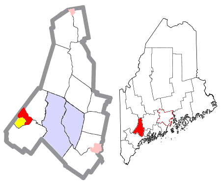
| Description | Map of the divisions of Androscoggin County, Maine, United States, with Mechanic Falls highlighted: the census-designated place of Mechanic Falls in red, and the rest of the town of Mechanic Falls in yellow. The cities of Auburn and Lewiston are light blue; other towns are white; and pink areas are census-designated places within other towns. | ||
| Date | |||
| Source | Modified by me from this United States Census Bureau file. | ||
| Auteur | Nyttend | ||
| Autorisation (Réutilisation de ce fichier) |
US Government work is public domain, and my work is
|
Historique du fichier
Cliquer sur une date et heure pour voir le fichier tel qu'il était à ce moment-là.
| Date et heure | Vignette | Dimensions | Utilisateur | Commentaire | |
|---|---|---|---|---|---|
| actuel | 25 juin 2008 à 22:25 | | 450 × 386 (31 kio) | Nyttend | {{Information |Description=Map of the divisions of {{w|Androscoggin County, Maine|Androscoggin County}}, {{w|Maine}}, {{w|United States}}, with Mechanic Falls highlighted: the {{w|census-designated place}} of {{w|Mechanic Falls (CDP), Maine|Mechanic Falls |
Utilisation du fichier
La page suivante utilise ce fichier :
Usage global du fichier
Les autres wikis suivants utilisent ce fichier :
- Utilisation sur ar.wikipedia.org
- Utilisation sur cy.wikipedia.org
- Utilisation sur en.wikipedia.org
- Utilisation sur eu.wikipedia.org
- Utilisation sur fa.wikipedia.org
- Utilisation sur ht.wikipedia.org
- Utilisation sur it.wikipedia.org
- Utilisation sur sh.wikipedia.org
- Utilisation sur sr.wikipedia.org
- Utilisation sur tt.wikipedia.org
- Utilisation sur vo.wikipedia.org
- Utilisation sur www.wikidata.org
- Utilisation sur zh.wikipedia.org