Fichier:Alta2012.png
Taille de cet aperçu : 500 × 599 pixels. Autres résolutions : 200 × 240 pixels | 400 × 480 pixels | 641 × 768 pixels | 854 × 1 024 pixels | 1 708 × 2 048 pixels | 3 229 × 3 871 pixels.
Fichier d’origine (3 229 × 3 871 pixels, taille du fichier : 824 kio, type MIME : image/png)
Ce fichier et sa description proviennent de Wikimedia Commons.
Description
| Description |
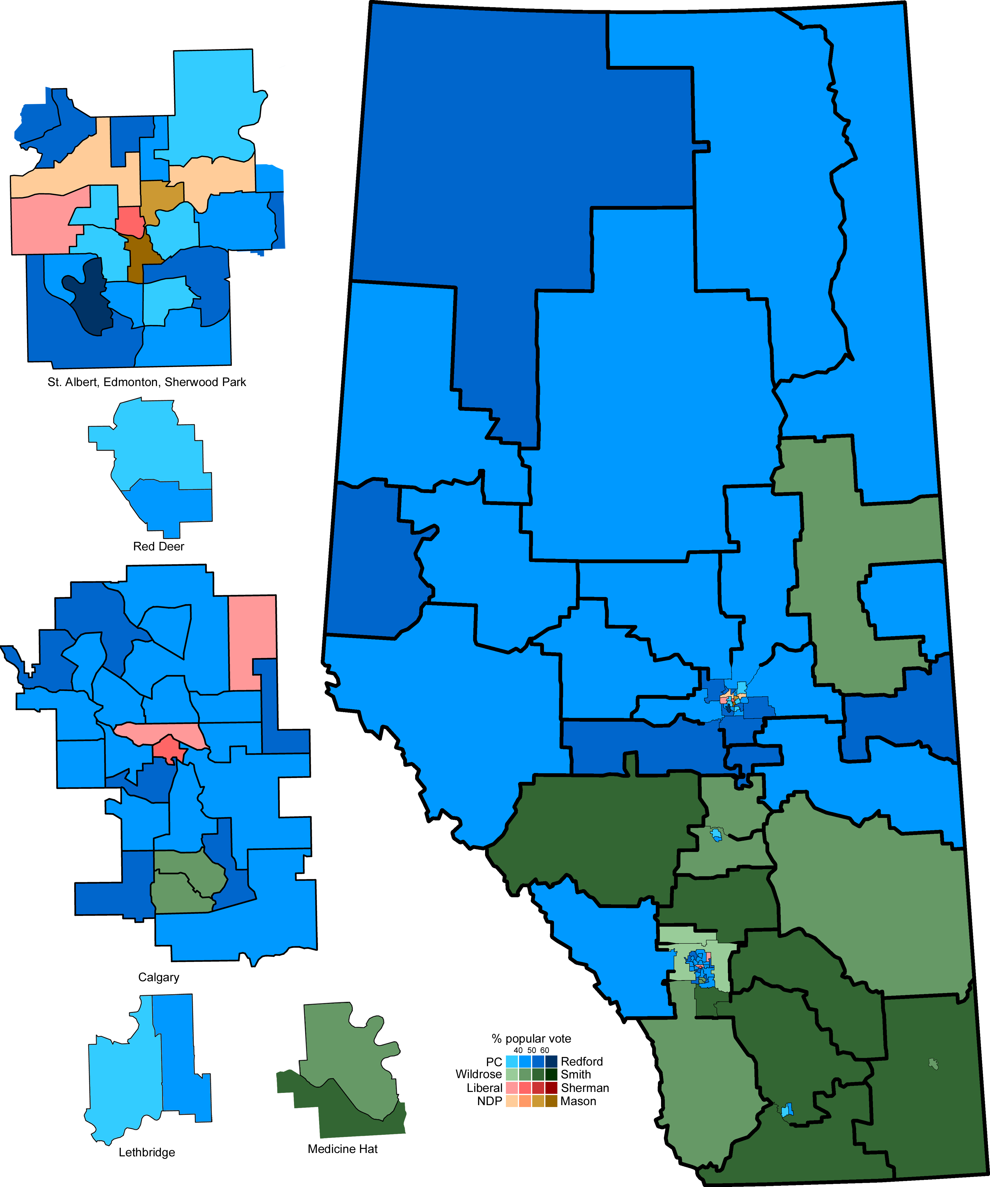
English: A map of the 87 Alberta provincial electoral districts, with the 2012 general election results. Inserts on the left are the cities of Edmonton, Red Deer, Calgary, Lethbridge, and Medicine Hat. |
| Date | |
| Source | Travail personnel |
| Auteur | 117Avenue |
| Autres versions |
|

| Alberta provincial election maps |
| 1905 · 1909 · 1913 · 1917 · 1921 · 1926 · 1930 · 1935 · 1940 · 1944 · 1948 · 1952 · 1955 · 1959 · 1963 · 1967 · 1971 · 1975 · 1979 · 1982 · 1986 · 1989 · 1993 · 1997 · 2001 · 2004 · 2008 · 2012 |
Conditions d’utilisation
| Moi, propriétaire des droits d’auteur sur cette œuvre, la place dans le domaine public. Ceci s'applique dans le monde entier. Dans certains pays, ceci peut ne pas être possible ; dans ce cas : J’accorde à toute personne le droit d’utiliser cette œuvre dans n’importe quel but, sans aucune condition, sauf celles requises par la loi. |
Historique du fichier
Cliquer sur une date et heure pour voir le fichier tel qu'il était à ce moment-là.
| Date et heure | Vignette | Dimensions | Utilisateur | Commentaire | |
|---|---|---|---|---|---|
| actuel | 27 avril 2012 à 02:40 | | 3 229 × 3 871 (824 kio) | 117Avenue | correct Calgary North-West |
| 26 avril 2012 à 04:11 |  | 3 229 × 3 871 (825 kio) | 117Avenue | remove outliers | |
| 25 avril 2012 à 05:32 |  | 3 229 × 3 871 (946 kio) | 117Avenue | full results | |
| 24 avril 2012 à 18:11 |  | 1 088 × 1 300 (33 kio) | Noname224 | Smaller, more consistent with past maps | |
| 24 avril 2012 à 13:46 |  | 3 229 × 3 871 (995 kio) | 117Avenue | try to size down again | |
| 24 avril 2012 à 13:36 |  | 3 871 × 4 641 (1,19 Mio) | 117Avenue | {{Information |Description ={{en|1=A map of the 87 Alberta provincial electoral districts, with the 2012 general election results. Inserts on the left are the cities of Edmonton, Red Deer, Calga... |
Utilisation du fichier
La page suivante utilise ce fichier :