Fichier:Aerial view of Hadleigh centre in the snow - geograph.org.uk - 1563668.jpg
Pas de plus haute résolution disponible.
Aerial_view_of_Hadleigh_centre_in_the_snow_-_geograph.org.uk_-_1563668.jpg (640 × 503 pixels, taille du fichier : 301 kio, type MIME : image/jpeg)
Ce fichier et sa description proviennent de Wikimedia Commons.
Description
| Description |
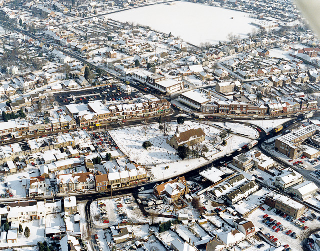
English: Aerial view of Hadleigh centre in the snow The church in the middle of the picture is St James-the-less. The large building below left of this is The Castle pub. Most of the buildings lining the major roads here are shops. The large white rectangle at the top is a school playing field, with the school to the right. |
| Date | |
| Source | From geograph.org.uk |
| Auteur | Edward Clack |
| Attribution (imposé par la licence) | Edward Clack / Aerial view of Hadleigh centre in the snow / |
| Lieu de la prise de vue | | Voir cet endroit et d’autres images sur : OpenStreetMap |
|---|
_heading:67.00&language=fr)
| Position de l'objet | | Voir cet endroit et d’autres images sur : OpenStreetMap |
|---|
_heading:67.00&language=fr)
Conditions d’utilisation

|
Cette image provient de la collection du projet Geograph British Isles. Pour obtenir les coordonnées du photographe, veuillez consulter cette page de description de l'image sur le site du projet. Les droits d'auteurs sur cette image sont détenus par Edward Clack ; l'image est placée sous une licence Creative Commons avec mention de paternité et partage à l'identique (CC-By-SA) en version 2.0.
|
Ce fichier est disponible selon les termes de la licence Creative Commons Attribution – Partage dans les Mêmes Conditions 2.0 Générique
Attribution: Edward Clack
- Vous êtes libre :
- de partager – de copier, distribuer et transmettre cette œuvre
- d’adapter – de modifier cette œuvre
- Sous les conditions suivantes :
- paternité – Vous devez donner les informations appropriées concernant l'auteur, fournir un lien vers la licence et indiquer si des modifications ont été faites. Vous pouvez faire cela par tout moyen raisonnable, mais en aucune façon suggérant que l’auteur vous soutient ou approuve l’utilisation que vous en faites.
- partage à l’identique – Si vous modifiez, transformez, ou vous basez sur cette œuvre, vous devez distribuer votre contribution sous la même licence ou une licence compatible avec celle de l’original.
Historique du fichier
Cliquer sur une date et heure pour voir le fichier tel qu'il était à ce moment-là.
| Date et heure | Vignette | Dimensions | Utilisateur | Commentaire | |
|---|---|---|---|---|---|
| actuel | 3 mars 2011 à 18:01 | | 640 × 503 (301 kio) | GeographBot | == {{int:filedesc}} == {{Information |description={{en|1=Aerial view of Hadleigh centre in the snow The church in the middle of the picture is St James-the-less. The large building below left of this is The Castle pub. Most of the buildings lining the maj |
Utilisation du fichier
La page suivante utilise ce fichier :
Usage global du fichier
Les autres wikis suivants utilisent ce fichier :
- Utilisation sur af.wikipedia.org
- Utilisation sur azb.wikipedia.org
- Utilisation sur ceb.wikipedia.org
- Utilisation sur cy.wikipedia.org
- Utilisation sur en.wikipedia.org
- Utilisation sur fa.wikipedia.org
- Utilisation sur ga.wikipedia.org
- Utilisation sur it.wikipedia.org
- Utilisation sur lld.wikipedia.org
- Utilisation sur nl.wikipedia.org
- Utilisation sur sv.wikipedia.org
- Utilisation sur vo.wikipedia.org
- Utilisation sur www.wikidata.org