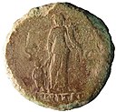
Fichier:A copper alloy Roman Sestertius of Trajan, AD.98-117, mint of Rome, Reece period 5 (FindID 870594).jpg

Fichier d’origine(6 023 × 3 276 pixels, taille du fichier : 7,83 Mio, type MIME : image/jpeg)

Ce fichier et sa description proviennent de Wikimedia Commons.

Description

A copper alloy Roman Sestertius of Trajan, AD.98-117, mint of Rome, Reece period 5
Photographe
The Portable Antiquities Scheme, Edwin Wood, 2017-10-18 16:24:21
Titre
A copper alloy Roman Sestertius of Trajan, AD.98-117, mint of Rome, Reece period 5
Description
English: A copper alloy Roman Sestertius of Trajan, AD.98-117, mint of Rome, Reece period 5, dating to AD 103-111. S P Q R OPTIMO PRINCIPI reverse type depicting Abundantia standing left holding ears of corn and cornucopiae; to left, [a child standing]. Mint of Rome. RIC II, p. 277, no. 459.
Lieu représenté (County of findspot) East Sussex
Date entre 96 et 117
Numéro d’inventaire
FindID: 870594
Old ref: SUSS-76DDA5
Filename: SestertiusSUSS76DDA5.jpg
Attribution de l’acquisition
The Portable Antiquities Scheme (PAS) is a voluntary programme run by the United Kingdom government to record the increasing numbers of small finds of archaeological interest found by members of the public. The scheme started in 1997 and now covers most of England and Wales. Finds are published at https://finds.org.uk
Source https://finds.org.uk/database/ajax/download/id/633839
Catalog: https://finds.org.uk/database/images/image/id/633839/recordtype/artefacts copie d'archive sur Wayback Machine
Artefact: https://finds.org.uk/database/artefacts/record/id/870594
Autorisation
(Réutilisation de ce fichier)
Attribution License
Autres versions
Position de l'objet50° 52′ 34,32″ N, 0° 25′ 36,32″ E Kartographer map based on OpenStreetMap.Voir cet endroit et d’autres images sur : OpenStreetMapinfo

Conditions d’utilisation

w:fr:Creative Commons
paternité
Ce fichier est disponible selon les termes de la licence Creative Commons Attribution 2.0 Générique.
Attribution: The Portable Antiquities Scheme
Vous êtes libre :
  • de partager – de copier, distribuer et transmettre cette œuvre
  • d’adapter – de modifier cette œuvre
Sous les conditions suivantes :
  • paternité – Vous devez donner les informations appropriées concernant l'auteur, fournir un lien vers la licence et indiquer si des modifications ont été faites. Vous pouvez faire cela par tout moyen raisonnable, mais en aucune façon suggérant que l’auteur vous soutient ou approuve l’utilisation que vous en faites.

Légendes

Ajoutez en une ligne la description de ce que représente ce fichier

Éléments décrits dans ce fichier

dépeint

50°52'34.3"N, 0°25'36.5"E

image/jpeg

04f41fc3d3daf395953a868c684ba5681843b27e

8 209 726 octet

3 276 pixel

6 023 pixel

Historique du fichier

Cliquer sur une date et heure pour voir le fichier tel qu'il était à ce moment-là.

Date et heureVignetteDimensionsUtilisateurCommentaire
actuel11 décembre 2018 à 13:12Vignette pour la version du 11 décembre 2018 à 13:126 023 × 3 276 (7,83 Mio)Portable Antiquities Scheme, SUSS, FindID: 870594, roman, page 787, batch count 13863

Aucune page n’utilise ce fichier.

Métadonnées