Fichier:AMH-4720-NA The forts of Nassau and Belgica and the Neira redoubt on Banda Neira.jpg

Fichier d’origine (2 400 × 1 905 pixels, taille du fichier : 858 kio, type MIME : image/jpeg)
Ce fichier et sa description proviennent de Wikimedia Commons.
Description
| Nederlands: Forten Nassau en Belgica en redoute Neira op Banda Neira
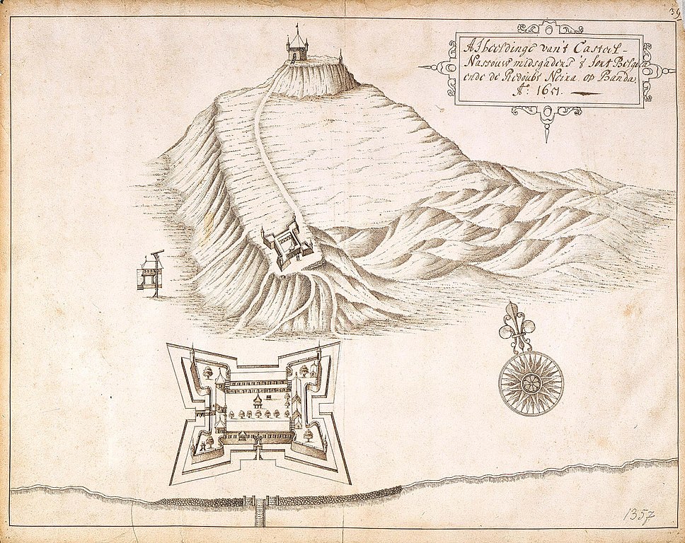
English: The forts of Nassau and Belgica and the Neira redoubt on Banda Neira ( |
||||||||||||||||||||||||
|---|---|---|---|---|---|---|---|---|---|---|---|---|---|---|---|---|---|---|---|---|---|---|---|---|
| Auteur |
Nederlands: Johannes (van) Nessel (toegeschreven aan landmeter/kaartenmaker)
English: Johannes (van) Nessel (assigned to land surveyor / mapmaker) |
|||||||||||||||||||||||
| Titre |
Nederlands: Forten Nassau en Belgica en redoute Neira op Banda Neira
English: The forts of Nassau and Belgica and the Neira redoubt on Banda Neira |
|||||||||||||||||||||||
| Description |
Nederlands: Titel catalogus Leupe (NA): Afbeeldinge van 't Casteel Nassauw, mitsgaders 't fort Belgica ende redoubt Neira op Banda.
Behoort bij het rapport van Arnold de Vlamingh van Outshoorn. Rechts boven genummerd: 392. De randen zijn aan de achterzijde beplakt. Notities verso: 392 [moet het folionummer in de band OBP zijn] / 664 [over de letter achter dit getal is een strook geplakt].English: According to the Leupe catalogue (NA), the original title reads: Afbeeldinge van 't Casteel Nassauw, mitsgaders 't fort Belgica ende redoubt Neira op Banda.
Belongs with the report of Arnold de Vlamingh van Outshoorn. Numbered top right: 392. The edges have been reinforced on the back. Notes on reverse: 392 [must refer to the folio number in the OBP volume]/664[the letter following the number has been obscured by a strip of paper]. |
|||||||||||||||||||||||
| Date | 1651 | |||||||||||||||||||||||
| Technique / matériaux |
Nederlands: pen op papier
English: pen on paper |
|||||||||||||||||||||||
| Dimensions | hauteur : 41,5 cm ; largeur : 33 cm | |||||||||||||||||||||||
| Collection |
|
|||||||||||||||||||||||
| Numéro d’inventaire |
NL-HaNA_4.VEL_1357 (old number: VEL1357) |
|||||||||||||||||||||||
| Inscriptions |
Afbeeldinge van 't Casteel Nassauw, midsgaders 't fort Belgica ende redoubt Neira op Banda
|
|||||||||||||||||||||||
| Notes |
English: Subjects: survey / view, compass / dial, fortification, banderole / cartouche / ornamentation
Nederlands: Onderwerpen: overzicht / aanzicht, kompas / windroos, vesting, banderol / cartouche / versiering
English: Fort: this image is related to a VOC fort called fort Belgica |
|||||||||||||||||||||||
| Source / photographe |
|
|||||||||||||||||||||||
| Autorisation (Réutilisation de ce fichier) |
|
|||||||||||||||||||||||

| Position de l'objet | | Voir cet endroit et d’autres images sur : OpenStreetMap |
|---|
Historique du fichier
Cliquer sur une date et heure pour voir le fichier tel qu'il était à ce moment-là.
| Date et heure | Vignette | Dimensions | Utilisateur | Commentaire | |
|---|---|---|---|---|---|
| actuel | 10 juin 2014 à 19:08 | | 2 400 × 1 905 (858 kio) | HuskyBot | == {{int:filedesc}} == {{Artwork |title = {{nl|1=Forten Nassau en Belgica en redoute Neira op Banda Neira}} {{en|1=The forts of Nassau and Belgica and the Neira redoubt on Banda Neira}} |description = {{nl|1=Ti... |
Utilisation du fichier
La page suivante utilise ce fichier :
Usage global du fichier
Les autres wikis suivants utilisent ce fichier :
- Utilisation sur en.wikipedia.org
- Utilisation sur es.wikipedia.org
- Utilisation sur mt.wikipedia.org