Fichier:AERIAL LOOKING NORTHEAST (CLOSE-UP) - Isla de Mona Light, Mona Island, Cabo Rojo, Cabo Rojo Municipio, PR HAER PR,58-IMON,1-22.tif

Taille de cet aperçu JPG pour ce fichier TIF : 754 × 599 pixels. Autres résolutions : 302 × 240 pixels | 604 × 480 pixels | 967 × 768 pixels | 1 280 × 1 017 pixels | 2 560 × 2 034 pixels | 4 998 × 3 972 pixels.
Fichier d’origine (4 998 × 3 972 pixels, taille du fichier : 18,94 Mio, type MIME : image/tiff)
Ce fichier et sa description proviennent de Wikimedia Commons.
Description
| AERIAL LOOKING NORTHEAST (CLOSE-UP) - Isla de Mona Light, Mona Island, Cabo Rojo, Cabo Rojo Municipio, PR | ||||
|---|---|---|---|---|
| Titre |
AERIAL LOOKING NORTHEAST (CLOSE-UP) - Isla de Mona Light, Mona Island, Cabo Rojo, Cabo Rojo Municipio, PR |
|||
| Description |
U.S. Department of Commerce; U.S. Coast Guard; Central Lighthouse Commission; Sautter, Lemonnier, and Cie; Cary, Brian, transmitter; Murphy, Kevin, transmitter; Boucher, Jack E, photographer; Nistal-Moret, Benjamin, historian |
|||
| Lieu représenté | Puerto Rico; Cabo Rojo Municipio; Cabo Rojo | |||
| Date | Documentation compiled after 1968 | |||
| Dimensions | 4 x 5 in. | |||
| Lieu actuel |
Library of Congress Prints and Photographs Division Washington, D.C. 20540 USA http://hdl.loc.gov/loc.pnp/pp.print |
|||
| Numéro d’inventaire |
HAER PR,58-IMON,1-22 |
|||
| Attribution de l’acquisition |
|
|||
| Notes |
|
|||
| Source | https://www.loc.gov/pictures/item/pr0047.photos.143458p | |||
| Autorisation (Réutilisation de ce fichier) |
|
|||

| Position de l'objet | | Voir cet endroit et d’autres images sur : OpenStreetMap |
|---|
Historique du fichier
Cliquer sur une date et heure pour voir le fichier tel qu'il était à ce moment-là.
| Date et heure | Vignette | Dimensions | Utilisateur | Commentaire | |
|---|---|---|---|---|---|
| actuel | 1 août 2014 à 12:24 | 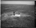 | 4 998 × 3 972 (18,94 Mio) | Fæ | GWToolset: Creating mediafile for Fæ. HABS 31 July 2014 (3000:3200) |
Utilisation du fichier
Les 2 pages suivantes utilisent ce fichier :