Fichier:3823 - Riffelberg - View from Gornergratbahn.JPG

Taille de cet aperçu : 800 × 600 pixels. Autres résolutions : 320 × 240 pixels | 640 × 480 pixels | 1 024 × 768 pixels | 1 280 × 960 pixels | 2 560 × 1 920 pixels | 3 648 × 2 736 pixels.
Fichier d’origine (3 648 × 2 736 pixels, taille du fichier : 2,69 Mio, type MIME : image/jpeg)
Ce fichier et sa description proviennent de Wikimedia Commons.
| Description |
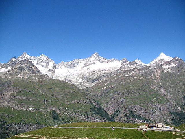
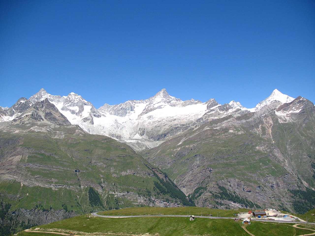
Deutsch: Ausblick von der Gornergratbahn, Riffelberg / Zermatt, Schweiz. Im Hintergrund von links nach rechts der Ober Gabelhorn (4.063 m.ü.M.), Wellenkuppe (3.903 m.ü.M.), Trifthorn (3.728 m.ü.M.), Pointe du Mountet (3.877 m.ü.M.), Zinalrothorn (4.221 m.ü.M., Bildmitte), Pointe Sud du Moming (3.963 m.ü.M.), Schahhorn (3.974,5 m.ü.M.) und Weisshorn (4.505 m). Im Vordergrund, vor den Ober Gabelhorn, liegt der Unter Gabelhorn (3.391,7 m.ü.M.). In den Grat laufend vom Zinalrothorn liegen zwei Nebengipfel, der Ober Äschhorn (3669 m.ü.M.) und der Unter Äschhorn (3.618 m.ü.M.). Weiter gibt es im Vordergrund von links nach rechts den Wisshorn (2.936 m.ü.M.), den Platthorn (3.345 m.ü.M.) und den Mettelhorn (3.406,0 m.ü.M.). Alle gehören zu den Walliser Alpen
English: View from the Gornergratbahn, Riffelberg / Zermatt, Switzerland. In the background from the left to the right the Ober Gabelhorn (4063 metres), Wellenkuppe (3903 m), Trifthorn (3728 m), Pointe du Mountet (3877 m), Zinalrothorn (4221 m, centre of the image), Pointe Sud du Moming (3963 m), Schahhorn (3974.5 m) and Weisshorn (4505 m). In the foreground, in front of the Ober Gabelhorn, lies the Unter Gabelhorn (3391.7 m). In the ridge coming from the Zinalrothorn are two side summits, the Ober Äschhorn (3669 m) and the Unter Äschhorn (3618 m). Further one can find in the foreground, from left to right, the Wisshorn (2936 m), Platthorn (3345 m) and Mettelhorn (3406.0 m). All mountains are part of the Wallis or Pennine Alps
Nederlands: Blik vanaf de Gornergratbahn, Riffelberg/Zermatt, Zwitserland. In de achtergrond van links naar rechts de Ober Gabelhorn (4063 meter), de Wellenkuppe (3903 m), de Trifthorn (3728 m), de Pointe du Mountet (3877 m), de Zinalrothorn (4221 m, midden op de foto), Pointe Sud du Moming (3963 m), Schahhorn (3974,5 m) en de Weisshorn. Op de voorgrond, voor de Ober Gabelhorn, ligt de Unter Gabelhorn (3391,7 m). In de graat lopend vanaf de top van de Zinalrothorn liggen twee neventoppen, de Ober Äschhorn (3669 m) en de Unter Äschhorn (3618 m). Verder zijn op de voorgrond, van links naar rechts, de Wisshorn (2936 m), de Platthorn (3345 m) en de Mettelhorn (3406.0 m) te zien. Alle bergen maken deel uit van de Walliser Alpen
|
||||
| Date | |||||
| Source | Travail personnel | ||||
| Auteur | Andrew Bossi | ||||
| Autorisation (Réutilisation de ce fichier) |
Own work, share alike, attribution required (Creative Commons CC-BY-SA-2.5) |
Moi, en tant que détenteur des droits d’auteur sur cette œuvre, je la publie sous la licence suivante :
Ce fichier est disponible selon les termes de la licence Creative Commons Attribution – Partage dans les Mêmes Conditions 2.5 Générique
- Vous êtes libre :
- de partager – de copier, distribuer et transmettre cette œuvre
- d’adapter – de modifier cette œuvre
- Sous les conditions suivantes :
- paternité – Vous devez donner les informations appropriées concernant l'auteur, fournir un lien vers la licence et indiquer si des modifications ont été faites. Vous pouvez faire cela par tout moyen raisonnable, mais en aucune façon suggérant que l’auteur vous soutient ou approuve l’utilisation que vous en faites.
- partage à l’identique – Si vous modifiez, transformez, ou vous basez sur cette œuvre, vous devez distribuer votre contribution sous la même licence ou une licence compatible avec celle de l’original.
| Annotations | Cette image est annotée : Voir les annotations sur Wikimedia Commons |
Historique du fichier
Cliquer sur une date et heure pour voir le fichier tel qu'il était à ce moment-là.
| Date et heure | Vignette | Dimensions | Utilisateur | Commentaire | |
|---|---|---|---|---|---|
| actuel | 4 novembre 2007 à 00:28 | | 3 648 × 2 736 (2,69 Mio) | Thisisbossi | {{Information |Description={{de|Schauen vom die Gornergratbahn, Riffelberg / Zermatt, Schweiz}} {{en|View from the Gornergratbahn, [[:en:Riffelberg|Riffelberg |
Utilisation du fichier
La page suivante utilise ce fichier :
Usage global du fichier
Les autres wikis suivants utilisent ce fichier :
- Utilisation sur de.wikipedia.org
- Utilisation sur it.wikipedia.org
- Utilisation sur nn.wikipedia.org
- Utilisation sur pnb.wikipedia.org