Fichier:2016 Freedom House world map.png
Taille de cet aperçu : 800 × 405 pixels. Autres résolutions : 320 × 162 pixels | 640 × 324 pixels | 1 024 × 518 pixels | 1 280 × 648 pixels | 2 560 × 1 296 pixels | 4 972 × 2 517 pixels.
Fichier d’origine (4 972 × 2 517 pixels, taille du fichier : 361 kio, type MIME : image/png)
Ce fichier et sa description proviennent de Wikimedia Commons.
Description
| Description |
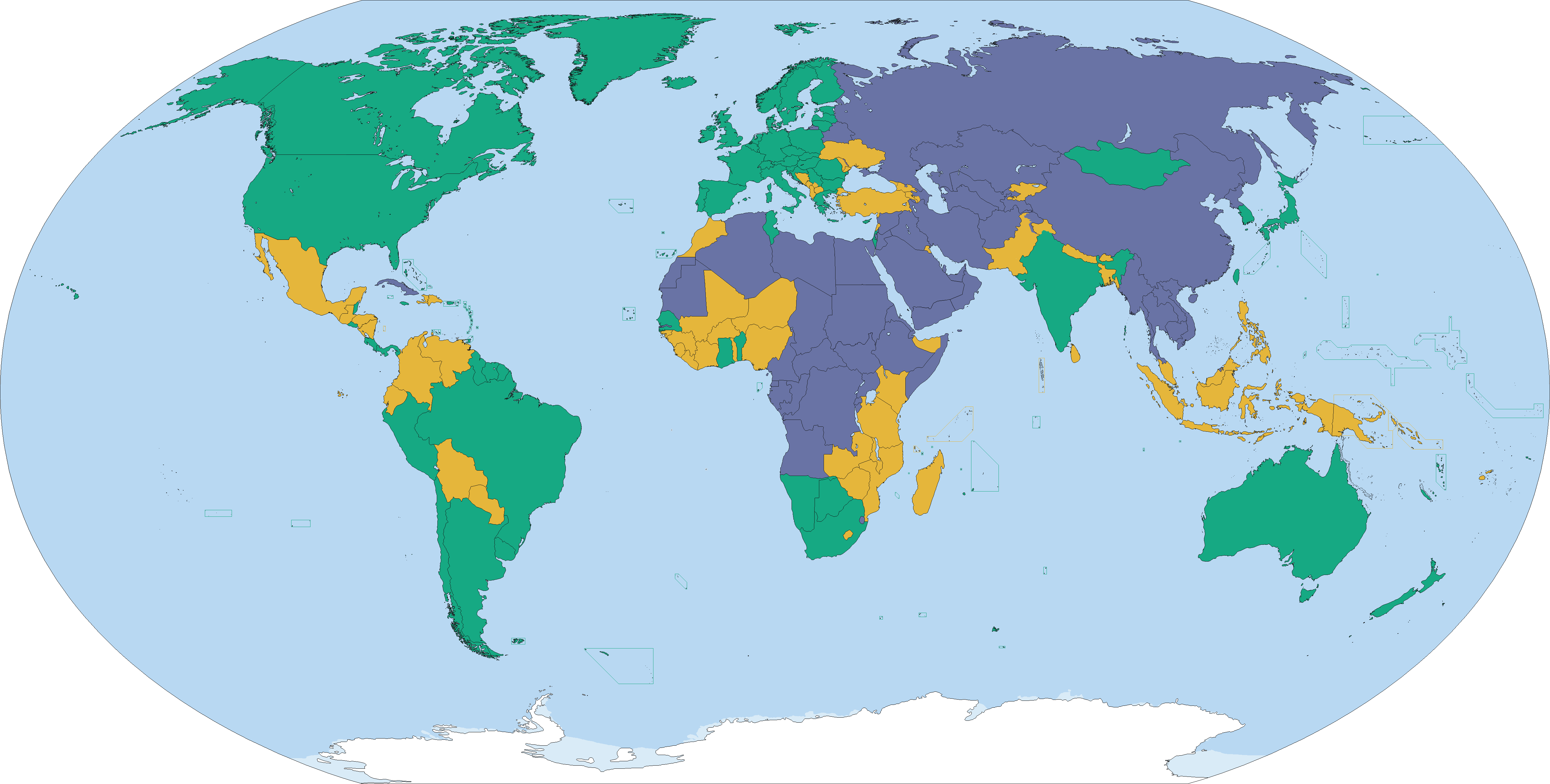
English: Country ratings from Freedom House's Freedom in the World 2016 survey, concerning the state of world freedom in 2015.[1]
Free (86) Partly Free (59) Not Free (50) See also: File:2015 Freedom House world map.png, File:2013_Freedom_House_world_map.svg |
| Date | |
| Source | Travail personnel |
| Auteur | Abrahamic Faiths |
Conditions d’utilisation
Moi, en tant que détenteur des droits d’auteur sur cette œuvre, je la publie sous la licence suivante :
Ce fichier est sous la licence Creative Commons Attribution – Partage dans les Mêmes Conditions 4.0 International.
- Vous êtes libre :
- de partager – de copier, distribuer et transmettre cette œuvre
- d’adapter – de modifier cette œuvre
- Sous les conditions suivantes :
- paternité – Vous devez donner les informations appropriées concernant l'auteur, fournir un lien vers la licence et indiquer si des modifications ont été faites. Vous pouvez faire cela par tout moyen raisonnable, mais en aucune façon suggérant que l’auteur vous soutient ou approuve l’utilisation que vous en faites.
- partage à l’identique – Si vous modifiez, transformez, ou vous basez sur cette œuvre, vous devez distribuer votre contribution sous la même licence ou une licence compatible avec celle de l’original.
- ↑ https://freedomhouse.org/sites/default/files/FH_FITW_Report_2016.pdf Freedom in the World 2016], Freedom House. Retrieved 28 January 2016.
Historique du fichier
Cliquer sur une date et heure pour voir le fichier tel qu'il était à ce moment-là.
| Date et heure | Vignette | Dimensions | Utilisateur | Commentaire | |
|---|---|---|---|---|---|
| actuel | 4 mai 2016 à 20:25 | | 4 972 × 2 517 (361 kio) | VulpesVulpes42 | Fixed some island borders. |
| 20 avril 2016 à 20:42 |  | 4 972 × 2 517 (361 kio) | VulpesVulpes42 | Fixed three pixels in Somaliland that were brighter for no reason, as well as an area in Ethiopia that was darker for no reason. | |
| 9 avril 2016 à 20:39 |  | 4 972 × 2 517 (361 kio) | VulpesVulpes42 | Isn't it weird how doing the exact same thing using gimp doesn't double the file size? | |
| 9 avril 2016 à 20:14 |  | 4 972 × 2 517 (361 kio) | VulpesVulpes42 | Reverted to version as of 10:02, 3 April 2016 (UTC) For some reason this file was much larger than the previous version. I expected it to become smaller. Maybe because I used paint. Lesson learned, always use gimp. | |
| 9 avril 2016 à 20:12 |  | 4 972 × 2 517 (622 kio) | VulpesVulpes42 | Fixed an area where the shade of green was darker and the shade of yellow lighter for no apparent reason. | |
| 3 avril 2016 à 12:02 |  | 4 972 × 2 517 (361 kio) | VulpesVulpes42 | Removed Tibet from the map. First off, why should this map show only Tibet but not the other autonomous regions? They have the same political status within the PRC. Secondly, as far as my understanding goes, this map should only show sovereign states,... | |
| 27 mars 2016 à 18:56 |  | 4 972 × 2 517 (382 kio) | Christian Ferrer | Reverted to version as of 08:54, 26 March 2016 (UTC) | |
| 27 mars 2016 à 17:33 |  | 4 972 × 2 517 (399 kio) | Insidema | Reverted to version as of 16:52, 25 March 2016 (UTC) | |
| 26 mars 2016 à 10:54 |  | 4 972 × 2 517 (382 kio) | Ankry | Reverted to version as of 16:39, 28 January 2016 (UTC) | |
| 25 mars 2016 à 18:52 |  | 4 972 × 2 517 (399 kio) | Hpyounes | Somaliland is not a sovereign State |
Utilisation du fichier
Les 2 pages suivantes utilisent ce fichier :
Usage global du fichier
Les autres wikis suivants utilisent ce fichier :
- Utilisation sur ar.wikipedia.org
- Utilisation sur be-tarask.wikipedia.org
- Utilisation sur bg.wikipedia.org
- Utilisation sur ca.wikipedia.org
- Utilisation sur de.wikipedia.org
- Utilisation sur en.wikipedia.org
- Utilisation sur fa.wikipedia.org
- Utilisation sur gn.wikipedia.org
- Utilisation sur gu.wikipedia.org
- Utilisation sur hy.wikipedia.org
- Utilisation sur id.wikipedia.org
- Utilisation sur it.wikipedia.org
- Utilisation sur ja.wikipedia.org
- Utilisation sur ko.wikipedia.org
- Utilisation sur pt.wikipedia.org
- Utilisation sur ru.wikipedia.org
- Utilisation sur simple.wikipedia.org
- Utilisation sur th.wikipedia.org
- Utilisation sur uk.wikipedia.org
- Utilisation sur zh.wikipedia.org