Fichier:2009 Euro ElectionMap.png
Taille de cet aperçu : 525 × 599 pixels. Autres résolutions : 210 × 240 pixels | 420 × 480 pixels | 673 × 768 pixels | 1 131 × 1 291 pixels.
Fichier d’origine (1 131 × 1 291 pixels, taille du fichier : 32 kio, type MIME : image/png)
Ce fichier et sa description proviennent de Wikimedia Commons.
Description
| Description |
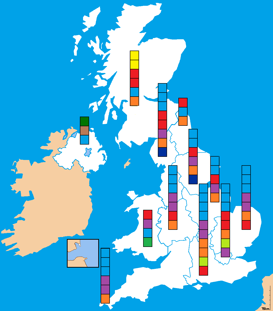
English: A map of British constituencies used for the 2009 European Parliament Election. Colours indicate winning party. |
| Date | |
| Source | Travail personnel |
| Auteur | Mwhite148 |
Conditions d’utilisation
| Moi, propriétaire des droits d’auteur sur cette œuvre, la place dans le domaine public. Ceci s'applique dans le monde entier. Dans certains pays, ceci peut ne pas être possible ; dans ce cas : J’accorde à toute personne le droit d’utiliser cette œuvre dans n’importe quel but, sans aucune condition, sauf celles requises par la loi. |
Historique du fichier
Cliquer sur une date et heure pour voir le fichier tel qu'il était à ce moment-là.
| Date et heure | Vignette | Dimensions | Utilisateur | Commentaire | |
|---|---|---|---|---|---|
| actuel | 21 juin 2015 à 14:20 | | 1 131 × 1 291 (32 kio) | DrKay | removing brown line on part of Scottish coast |
| 10 avril 2015 à 17:33 |  | 1 131 × 1 291 (32 kio) | DrKay | parties ranked top to bottom in order of vote share per region | |
| 28 mai 2011 à 14:08 |  | 1 131 × 1 291 (64 kio) | Bastin | Correct NW England (Lib Dem was denominated yellow, which is SNP - not sure they have an MEP south of the border!). | |
| 23 octobre 2010 à 17:02 |  | 1 131 × 1 291 (55 kio) | Mwhite148 | {{Information |Description={{en|1=A map of British constituencies used for the 2009 European Parliament Election. Colours indicate winning party.}} |Source={{own}} |Author=Mwhite148 |Date=2010-10-23 |Permission= |other_versions= }} [[C |
Utilisation du fichier
Aucune page n’utilise ce fichier.
Usage global du fichier
Les autres wikis suivants utilisent ce fichier :
- Utilisation sur cy.wikipedia.org
- Utilisation sur de.wikipedia.org
- Utilisation sur en.wikipedia.org
- Utilisation sur fa.wikipedia.org