Fichier:1945-04-15GerWW2BattlefrontAtlas.jpg

Taille de cet aperçu : 609 × 600 pixels. Autres résolutions : 244 × 240 pixels | 488 × 480 pixels | 780 × 768 pixels | 1 236 × 1 217 pixels.
Fichier d’origine (1 236 × 1 217 pixels, taille du fichier : 1,27 Mio, type MIME : image/jpeg)
Ce fichier et sa description proviennent de Wikimedia Commons.
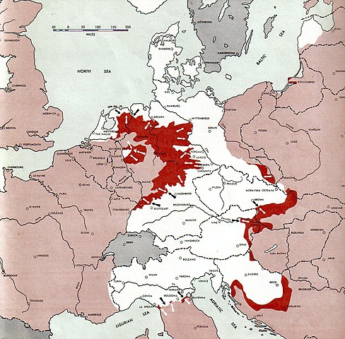
Atlas of the World Battle Fronts - War against Germany: 1945-04-15
← Previous map: 1945-04-01
→ Next map: 1945-05-01
Description
| Description |
Neutral nations (Sweden, Switzerland, Spain, etc.)
Under Allied control
Allied forces
Axis forces
  July 1, 1943 to June 30 1945 To the Secretary of War". (See Cover, Forward and Map details)  |
| Date | |
| Source | Document "Atlas of the World Battle Fronts in Semimonthly Phases to August 15th 1945: Supplement to The Biennial report of the Chief of Staff of the United States Army July 1, 1943 to June 30 1945 To the Secretary of War" |
| Auteur | Army Map Service |
| Autorisation (Réutilisation de ce fichier) |
Public Domain: Work of US army |
Conditions d’utilisation
Cette image est une œuvre d'un soldat ou d'un employé de l'U.S. Army, réalisée dans le cadre de ses activités professionnelles. En tant qu'œuvre du gouvernement fédéral des États-Unis d'Amérique, cette image fait partie du domaine public.
|
 |
Historique du fichier
Cliquer sur une date et heure pour voir le fichier tel qu'il était à ce moment-là.
| Date et heure | Vignette | Dimensions | Utilisateur | Commentaire | |
|---|---|---|---|---|---|
| actuel | 28 août 2011 à 12:06 | | 1 236 × 1 217 (1,27 Mio) | Cropbot | upload cropped version, operated by User:Finavon. Summary: caption cropped |
| 24 décembre 2007 à 22:13 |  | 1 274 × 1 752 (1,79 Mio) | Mike Young | {{Information |Description= thumb|left|75pxthumb|right|75pxMap of the front against Germany: This map is taken from the source "Atlas of the World Battle Fronts in Semimonthly |
Utilisation du fichier
La page suivante utilise ce fichier :
Usage global du fichier
Les autres wikis suivants utilisent ce fichier :
- Utilisation sur ar.wikipedia.org
- Utilisation sur az.wikipedia.org
- Utilisation sur bg.wikipedia.org
- Utilisation sur da.wikipedia.org
- Utilisation sur de.wikipedia.org
- Utilisation sur el.wikipedia.org
- Utilisation sur en.wikipedia.org
- Utilisation sur en.wikisource.org
- Utilisation sur hr.wikipedia.org
- Utilisation sur id.wikipedia.org
- Utilisation sur mk.wikipedia.org
- Utilisation sur no.wikipedia.org
- Utilisation sur pt.wikipedia.org
- Utilisation sur ru.wikipedia.org
- Utilisation sur sh.wikipedia.org
- Utilisation sur sr.wikipedia.org
- Utilisation sur ta.wikipedia.org
- Utilisation sur vi.wikipedia.org
- Utilisation sur www.wikidata.org