Fichier:1866 Johnson Map of Montana, Wyoming, Idaho, Nebraska and Dakota - Geographicus - WyomingMontanaIdaho-johnson-1866.jpg
Fichier d’origine (5 000 × 3 750 pixels, taille du fichier : 5,45 Mio, type MIME : image/jpeg)
Ce fichier et sa description proviennent de Wikimedia Commons.
| Alvin Jewett Johnson : Johnson's Nebraska, Dakota, Idaho and Montana.
( |
|||||||||||||||||||||||
|---|---|---|---|---|---|---|---|---|---|---|---|---|---|---|---|---|---|---|---|---|---|---|---|
| Artiste |
|
||||||||||||||||||||||
| Titre |
Johnson's Nebraska, Dakota, Idaho and Montana. |
||||||||||||||||||||||
| Description |
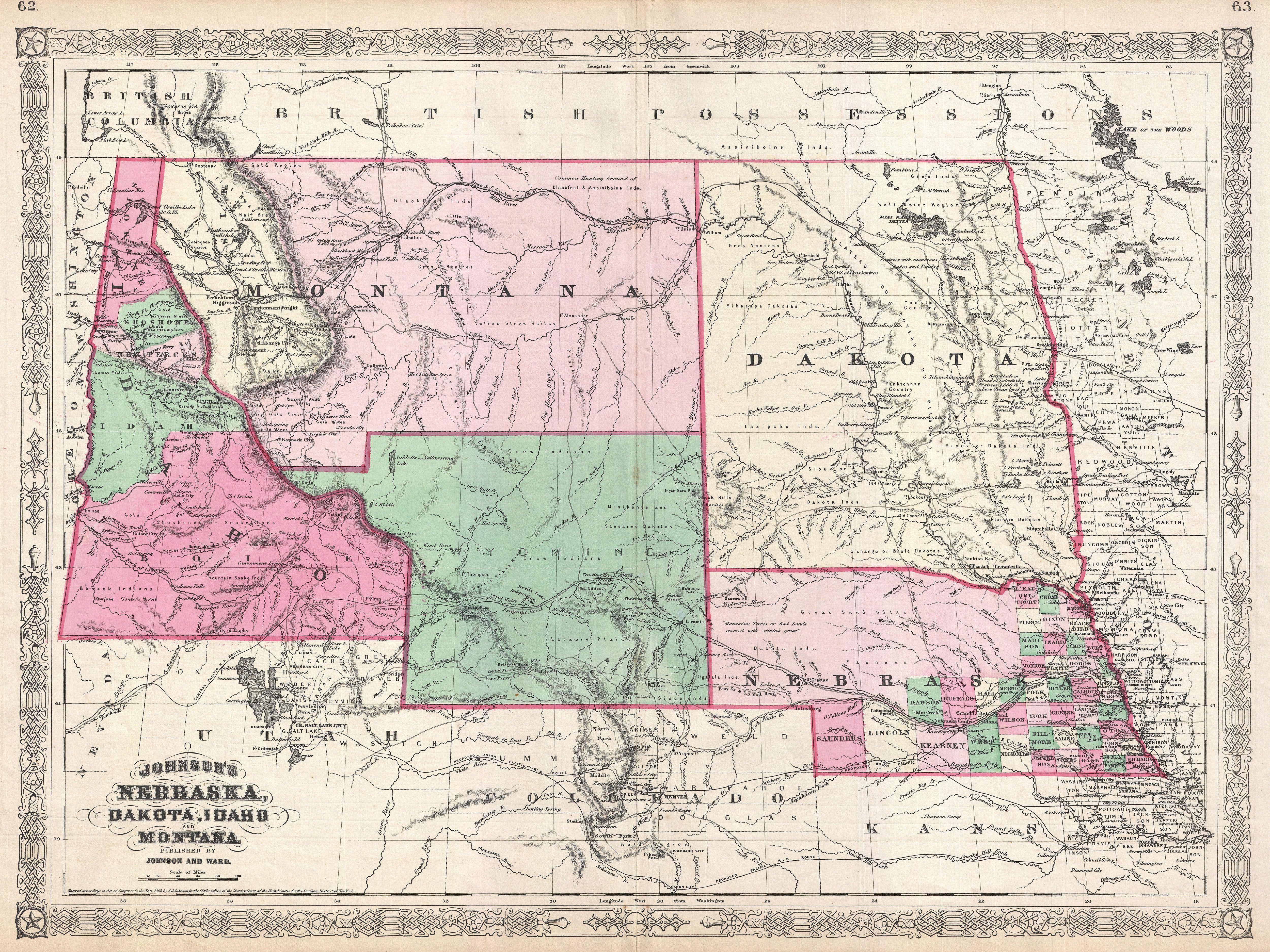
English: This is Johnson and Ward’s significant 1866 map of the Idaho, Montana, Wyoming, Dakota and Nebraska. Johnson first introduced this map in 1865 to accommodate a renewed interested in this region following the close of the American Civil War. During the Civil War period the vast Washington and Nebraska territories had been divided up into smaller territories including Idaho (1863), Montana (1864) and Dakota (1861). Though largely controlled by various American Indian nations, this region was becoming increasingly attractive for settlement and development. The proposed Governor Stevens route for the Northern Pacific Railroad passed through this region, as this region as did the more favorable Central Pacific Railroad route and, to a lesser extent, the proposed Union Pacific Railroad route. This is also the first Johnson map to incorporate Wyoming - which is absent from the 1865 edition of this map. Note that, though Wyoming is demarked as a territory, the lettering of the territorial title is in a light outline typeface - a sharp contrast to the bold titles for Montana, Dakota, and Idaho. This is due to the fact that though the territory of Wyoming had been proposed by Representative J. M. Ashley of Ohio in 1865, it was considered a temporary measure. The region was not officially incorporated as a territory until 1868. This early configuration of the territory also truncates the border with Montana at 44.5 degrees north latitude, giving Wyoming a curious ephemeral western panhandle. Within Montana the western portions beyond the Rocky Mountains, are highlighted and identified as Missoula. In 1865 this region had only recently been settled by traders and missionaries. Nonetheless, by 1866 it has become a stopping point for the Mullans Wagon Road, which is also identified. Throughout this map Johnson offers spectacular detail identifying explorers routes, mines, American Indian Nations, springs, forts, mountain passes, and an assortment of additional geographical and political elements. In particular he identifies all three proposed routes for the Pacific Railroad, the Emigrant Road, gold deposits in Montana and Idaho, Pike's Peak, Fremont's Peak, and Yellowstone Lake. Though copyrighted to 1865, this map was updated by Johnson for publication as plate nos. 62-63 in the 1866 edition of his New Illustrated Atlas… This is the last edition of the Johnson’s Atlas to bear the Johnson and Ward imprint and the first to include Wyoming. |
||||||||||||||||||||||
| Date | 1866 (dated 1865) | ||||||||||||||||||||||
| Dimensions | hauteur : 18 pouces (45,7 cm) | ||||||||||||||||||||||
| Numéro d’inventaire |
liens Geographicus : WyomingMontanaIdaho-johnson-1866 |
||||||||||||||||||||||
| Source / photographe |
Johnson, A. J., Johnson's New Illustrated Family Atlas of The World with Physical Geography, and with Descriptions Geographical, Statistical, and Historic including The Latest Federal Census, A Geographical Index, and a Chronological History of the Civil War in America, 1866.
|
||||||||||||||||||||||
| Autorisation (Réutilisation de ce fichier) |
|
||||||||||||||||||||||
Historique du fichier
Cliquer sur une date et heure pour voir le fichier tel qu'il était à ce moment-là.
| Date et heure | Vignette | Dimensions | Utilisateur | Commentaire | |
|---|---|---|---|---|---|
| actuel | 23 mars 2011 à 21:51 | | 5 000 × 3 750 (5,45 Mio) | BotMultichillT | {{subst:User:Multichill/Geographicus |link=http://www.geographicus.com/P/AntiqueMap/WyomingMontanaIdaho-johnson-1866 |product_name=1866 Johnson Map of Montana, Wyoming, Idaho, Nebraska and Dakota |map_title=Johnson's Nebraska, Dakota, Idaho and Montana. | |
Utilisation du fichier
La page suivante utilise ce fichier :
Usage global du fichier
Les autres wikis suivants utilisent ce fichier :
- Utilisation sur en.wikibooks.org