Fichier:1842 A new map of Michigan with its canals roads distances by H.S. Tanner.jpg

Fichier d’origine (3 352 × 4 286 pixels, taille du fichier : 11,62 Mio, type MIME : image/jpeg)
Ce fichier et sa description proviennent de Wikimedia Commons.
Description
| Description |
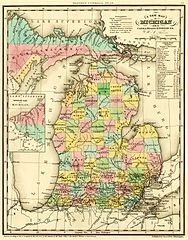
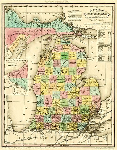
English: A new map of Michigan with its canals, roads & distances / by H.S. Tanner ; engd. by E.B. Dawson. Philadelphia : Carey & Hart, [1842].
Scan of a map in the collection of the Michigan State University Map Library. Original map was detached from an atlas published in 1842: A new universal atlas. Philadelphia : Carey & Hart, 1842. MSU Libraries catalog record: http://catalog.lib.msu.edu/record=b12049211~S39a The map shows early names (assigned 1840) of northern Michigan counties, many of which were renamed in 1843. Some of these names are misspelled: Correct spelling / Name on map:
|
|||||||||||||||||||
| Date | 1842, ©1841 | |||||||||||||||||||
| Source | http://www.lib.msu.edu/branches/map/MiJPEGS/843-D-1842-Tanner/ | |||||||||||||||||||
| Auteur |
|
|||||||||||||||||||
Conditions d’utilisation
Ce document est dans le domaine public aux États-Unis. Ceci s'applique aux travaux des États-Unis où le copyright a expiré, souvent parce que sa première publication s'est produite avant le 1er janvier 1929. Voir cette page pour davantage d'explication.
|
 | |
 |
Cette image peut ne pas être dans le domaine public en dehors des États-Unis (ceci s'applique particulièrement au Canada, en Chine (pas Hong Kong, Macao, ni Taïwan), en Allemagne ou en Suisse). Le créateur et l'année de la publication sont l'information essentielle et doivent être fournis.
|
Historique du fichier
Cliquer sur une date et heure pour voir le fichier tel qu'il était à ce moment-là.
| Date et heure | Vignette | Dimensions | Utilisateur | Commentaire | |
|---|---|---|---|---|---|
| actuel | 5 octobre 2016 à 21:04 | | 3 352 × 4 286 (11,62 Mio) | TimK MSI | cropped |
| 5 octobre 2016 à 21:03 |  | 4 095 × 5 296 (7,33 Mio) | TimK MSI | {{Information |Description ={{en|1=A new map of Michigan with its canals, roads & distances / by H.S. Tanner ; engd. by E.B. Dawson. Philadelphia : Carey & Hart, [1842]. Scan of a map in the collection of the Michigan State University Map Library.... |
Utilisation du fichier
Aucune page n’utilise ce fichier.
Usage global du fichier
Les autres wikis suivants utilisent ce fichier :
- Utilisation sur en.wikipedia.org