Fichier:1799 Cary Map of the Upper and Lower Rhine - Geographicus - Rhine-cary-1799.jpg
Taille de cet aperçu : 672 × 599 pixels. Autres résolutions : 269 × 240 pixels | 538 × 480 pixels | 861 × 768 pixels | 1 149 × 1 024 pixels | 2 297 × 2 048 pixels | 5 000 × 4 458 pixels.
Fichier d’origine (5 000 × 4 458 pixels, taille du fichier : 8,23 Mio, type MIME : image/jpeg)
Ce fichier et sa description proviennent de Wikimedia Commons.
Description
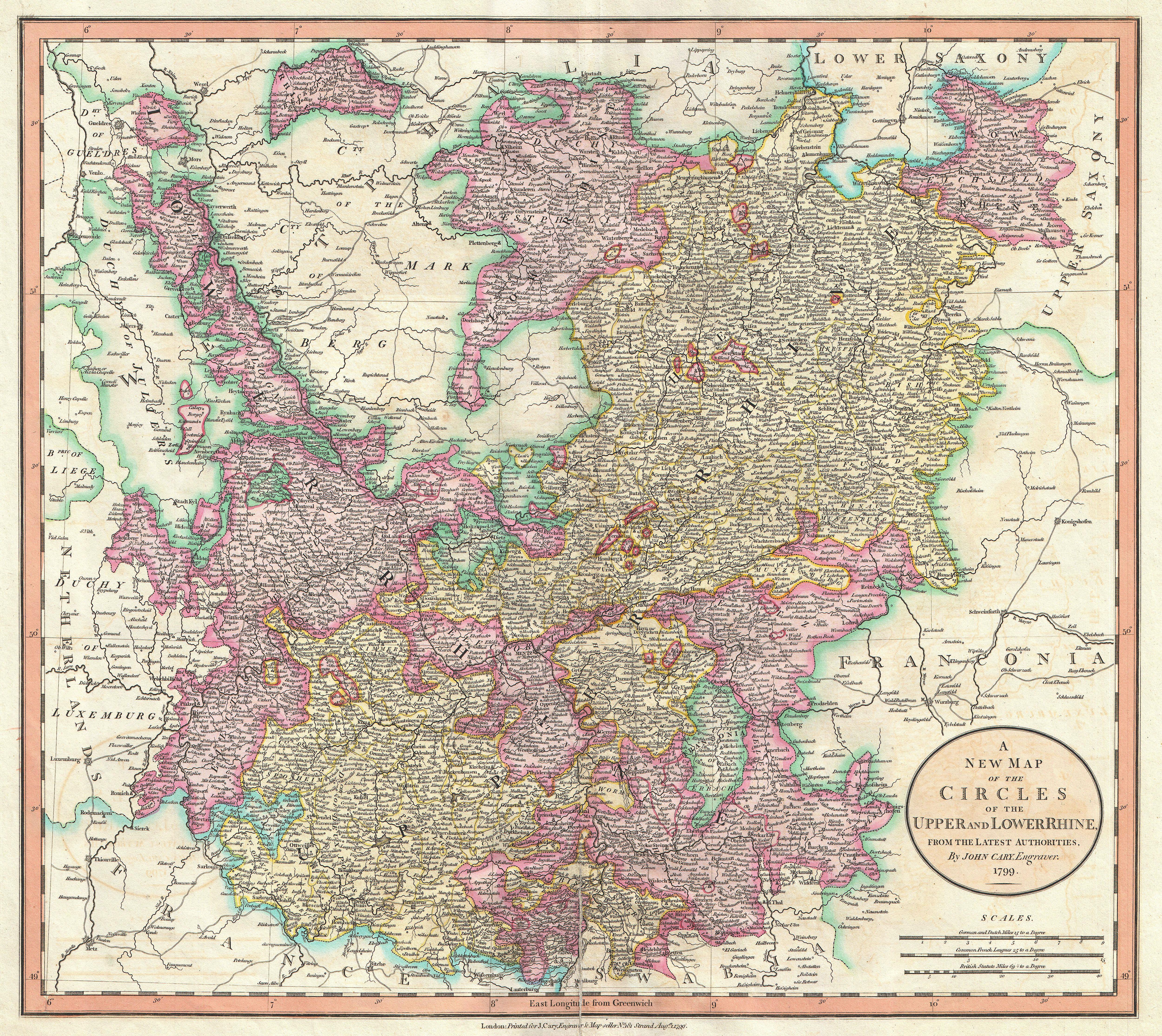
| John Cary : A New Map of the Circles of the Upper and Lower from the Latest Authorities.
( |
||||||||||||||||||||||||||
|---|---|---|---|---|---|---|---|---|---|---|---|---|---|---|---|---|---|---|---|---|---|---|---|---|---|---|
| Artiste |
|
|||||||||||||||||||||||||
| Titre |
A New Map of the Circles of the Upper and Lower from the Latest Authorities. |
|||||||||||||||||||||||||
| Description |
English: An extremely attractive example of John Cary’s 1799 map of the Upper and Lower Rhine, Germany. Covers Westphalia south to France and Swabia. Bordered on the west by the Netherlands and on the east by Franconia. Includes the important cities of Cologne (Koln) and Frankfurt. Highly detailed with color coding according to region. Shows forests, cities, palaces, forts, roads and rivers. All in all, one of the most interesting and attractive atlas maps of the Rhinelands to appear in first years of the 19th century. Prepared in 1799 by John Cary for issue in his magnificent 1808 New Universal Atlas . |
|||||||||||||||||||||||||
| Date | 1799 (dated) | |||||||||||||||||||||||||
| Dimensions | hauteur : 18,5 pouces (46,9 cm) ; largeur : 20,5 pouces (52 cm) | |||||||||||||||||||||||||
| Numéro d’inventaire |
liens Geographicus : Rhine-cary-1799 |
|||||||||||||||||||||||||
| Source / photographe |
Cary, John, Cary's New Universal Atlas, containing distinct maps of all the principal states and kingdoms throughout the World. From the latest and best authorities extant. London: Printed for J. Cary, Engraver and Map-seller, No. 181, near Norfolk Street, Strand, 1808.
|
|||||||||||||||||||||||||
| Autorisation (Réutilisation de ce fichier) |
|
|||||||||||||||||||||||||
Historique du fichier
Cliquer sur une date et heure pour voir le fichier tel qu'il était à ce moment-là.
| Date et heure | Vignette | Dimensions | Utilisateur | Commentaire | |
|---|---|---|---|---|---|
| actuel | 22 mars 2011 à 14:30 | | 5 000 × 4 458 (8,23 Mio) | BotMultichillT | {{subst:User:Multichill/Geographicus |link=http://www.geographicus.com/P/AntiqueMap/Rhine-cary-1799 |product_name=1799 Cary Map of the Upper and Lower Rhine |map_title=A New Map of the Circles of the Upper and Lower from the Latest Authorities. |descripti |
Utilisation du fichier
Les 4 pages suivantes utilisent ce fichier :