Fichier:1741 Covens and Mortier Map of the Southern Hemisphere ( South Pole, Antarctic) - Geographicus - SouthPole-covensmortier-1741.jpg
Taille de cet aperçu : 673 × 600 pixels. Autres résolutions : 269 × 240 pixels | 539 × 480 pixels | 862 × 768 pixels | 1 149 × 1 024 pixels | 2 298 × 2 048 pixels | 5 000 × 4 456 pixels.
Fichier d’origine (5 000 × 4 456 pixels, taille du fichier : 6,49 Mio, type MIME : image/jpeg)
Ce fichier et sa description proviennent de Wikimedia Commons.
_-_Geographicus_-_SouthPole-covensmortier-1741.jpg?uselang=fr)
| Covent & Mortier : L'Hemisphere Meridional pour voir plus distinctement Les Terres Australes.
( |
||||||||||||||||||||||||||
|---|---|---|---|---|---|---|---|---|---|---|---|---|---|---|---|---|---|---|---|---|---|---|---|---|---|---|
| Artiste |
|
|||||||||||||||||||||||||
| Titre |
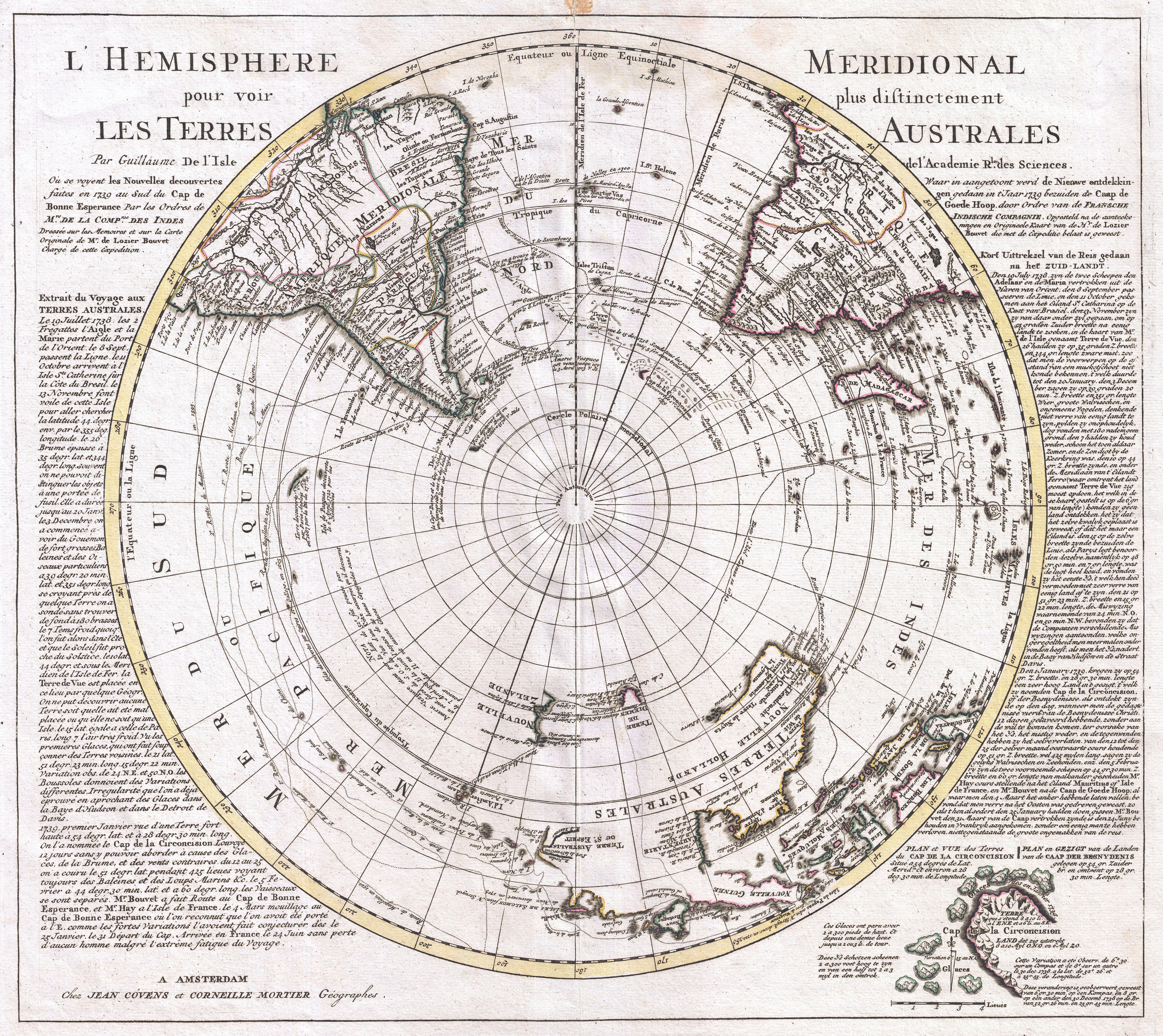
L'Hemisphere Meridional pour voir plus distinctement Les Terres Australes. |
|||||||||||||||||||||||||
| Description |
English: This is a stunning map of the Southern Hemisphere originally drawn by Guillaume de L'Isle and updated in 1739 by Covens and Mortier. Extends from the South Pole northwards in all directions as far as the Equator, encompassing in the process most of South America, southern Africa, Australia, and parts of the East Indies including Borneo, New Guinea, Java and Sumatra. Details the routes taken by numerous explorers including Magellan, Vespucci, Mendana, Dampier, L'Aigle, S. Louis, Halley, Quiros, Maire, Tasman, Davis and others. Many of the updates to this map over earlier versions focus on the explorations of Lozier de Bouvet. An account of Bouvet's explorations appears on both sides of the map proper - in French on the left and in Dutch on the right. Bouvet explored the Antarctic seas in the late 1730s. In January of 1739 Bouvet discovered an iceberg ridden sea and sighted an outcropping of land he called Cap de la Circoncision. Based upon Bouvet's calculations this would have been the southernmost point of land ever sighted. At the time, and for roughly 100 years previous, geographers had speculated on the existence of a Southern Continent. The idea of such a continent was based on a theory of balance. Geographers theorized that the weight of Asia had to be counter balanced by a similarly massive continent in the extreme South. The great proponent of this theory in the 18th century was Geographer to the King and Académie des Sciences member Philippe Buache de la Neuville. Bauche was the preeminent geographical theorist of his day and used Lozier's discoveries to promote his own ideas of a Southern Continent. Thus, returning to our map, we see evidence of Bauchian Antarctic theory in the inset detail of Cap de la Circoncision in the lower right quadrant. Bauche would later theorize that the Cap was actually attached to a great continent further south and that it was the outlet for a large Antarctic Sea. After Lozier de Bouvet, subsequent explorers had a great deal of difficulty finding Cap de la Circoncision. In the late 18th century Captain Cook searched for the Cap extensively on both his first and second voyages. One of Cook's associates, Captain Furneaux also searched the area with little success. The issue seems to have been a miscalculation by Bouvet regarding Longitude (a typical problem at the time) that placed the island about 23 degrees too far east. The land was finally rediscovered by Captain James Lindsay in 1808 who realized that it was in fact an island and not attached to a greater southern landmass. It was sighted again by the American whaling Captain Benjamin Morrell in 1822 who renamed it Bouvet's Island in honor of its original discoverer. On to other parts of the map. De L'Isle, based on only the sketchiest knowledge of the region obtained from the voyages of Abel Janszoon Tasman around Australia, maps Australia, or in this case Terres Australes, as attached to both Tasmania (Van Diemen's Land) and New Guinea. Despite this, the western parts of Australia are drawn with relative accuracy while the eastern portions are postulated with a dotted line. South America, roughly three quarters of which appears here, is well mapped along its shores though speculatively in the interior. Our map shows the Laguna de los Xarayes and the lands of the Xarayes, a corruption of Xaraiés meaning Masters of the River. The Xaraiés were an indigenous people occupying what are today parts of Brazil's Matte Grosso and the Pantanal. When Spanish and Portuguese explorers first navigated up the Paraguay River, as always in search of El Dorado, they encountered the vast Pantanal flood plain at the height of its annual inundation. Understandably misinterpreting the flood plain as a gigantic inland sea, they named it after the local inhabitants, the Xaraies. |
|||||||||||||||||||||||||
| Date | vers 1741(dated 1739) | |||||||||||||||||||||||||
| Dimensions | hauteur : 19 pouces (48,2 cm) ; largeur : 21 pouces (53,3 cm) | |||||||||||||||||||||||||
| Numéro d’inventaire |
liens Geographicus : SouthPole-covensmortier-1741 |
|||||||||||||||||||||||||
| Source / photographe |
Covens, J. & Mortier, C., Atlas nouveau, contenant toutes les parties su Monde, ou sont exactement remarquees les empires, monarchies, royaumes, etats, republiques, &c. Par Guillaume de l'Isle, c. 1841 editon.
|
|||||||||||||||||||||||||
| Autorisation (Réutilisation de ce fichier) |
|
|||||||||||||||||||||||||
Historique du fichier
Cliquer sur une date et heure pour voir le fichier tel qu'il était à ce moment-là.
| Date et heure | Vignette | Dimensions | Utilisateur | Commentaire | |
|---|---|---|---|---|---|
| actuel | 23 mars 2011 à 03:45 | | 5 000 × 4 456 (6,49 Mio) | BotMultichillT | {{subst:User:Multichill/Geographicus |link=http://www.geographicus.com/P/AntiqueMap/SouthPole-covensmortier-1741 |product_name=1741 Covens and Mortier Map of the Southern Hemisphere ( South Pole, Antarctic) |map_title=L'Hemisphere Meridional pour voir plu |
Utilisation du fichier
Aucune page n’utilise ce fichier.
_-_Geographicus_-_SouthPole-covensmortier-1741.jpg)