Fichier:12nm hypothetical Territorial Sea compared with Northern Limit Line, North Korea.jpg

Fichier d’origine (1 315 × 938 pixels, taille du fichier : 147 kio, type MIME : image/jpeg)
Ce fichier et sa description proviennent de Wikimedia Commons.
Description
| Description |
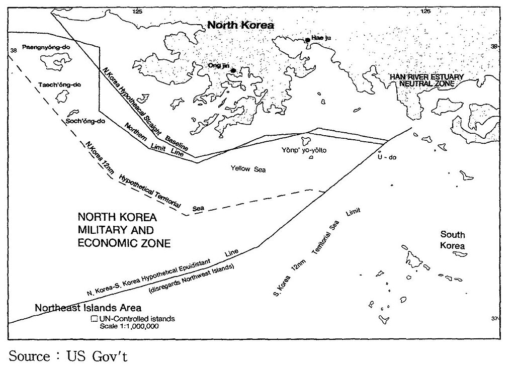
English: A US Government map showing where a North Korean 12 nautical mile Territorial Waters limit would be, when disregarding the north west UN Command islands, compared to the UN Command created Northern Limit Line. |
| Date | Date inconnue |
| Source | http://118.129.184.33/pub/docu/kr/AM/06/AM062001B01/IMAGE/AM06-2001-B01-0210-01.jpg |
| Auteur | US Government |
| Autres versions |
Œuvres dérivées de ce fichier : Yeonpyeong Island live firing range map.png:  |
Map taken from HTML version of the paper, which included this US Government credited map:
Seong-Geol Hong, Sun-Pyo Kim, Hyung-Ki Lee (2001-06-30). "Fisheries Cooperation and Maritime Delimitation Issues between North Korea and Its Neighboring Countries". Ocean Policy Research 16 (1): 191-216. Korea Maritime Institute. Archived from the original on 2011-07-23. Retrieved on 2010-11-28.
HTML version of paper: http://118.129.184.33/pub/docu/kr/AM/06/AM062001B01/AM06-2001-B01-006.HTM[lien mort]
According to a Korean Central News Agency article "Northern Limit Line rejected" of 2 August 2002[1] copie d'archive sur Wayback Machine "the U.S. government distributed [this map] to the participants in the UN conference on maritime law held in the U.S. in 1980". The map is also published in paper by Kim, Jung-Gun (Spring-Summer 1985). "Reflections on the attitude of North Korea toward the Law of the Sea (UNCLOS III Treaty)". Asian Perspective 9 (1)., and John Barry Kotch & Michael Abbey in Asian Perspective, Vol. 27, No. 2, 2003, pp. 175-204 copie d'archive sur Wayback Machine.
The CIA report "The West Coast Korean Islands", BGI RP 74-9, January 1974 (Declassified 2000-04-18 as CIA-RDP-84-00825R000300120001-7)[2] describes this, or a very similar, map. However the map itself is redacted from the declassified version of the report.
Conditions d’utilisation
Ce média est dans le domaine public des États-Unis d’Amérique car son auteur est l’administration américaine comme précisé dans le code fédéral au Titre 17, Chapitre 1, Section 105. Pour en savoir plus : droit d’auteur.
Attention : Ceci ne concerne que le travail du Gouvernement Fédéral et pas celui des États, ou d’une autre subdivision géographique ou politique du pays.
|
 | |
| Ce fichier a été identifié comme étant exempt de restrictions connues liées au droit d’auteur, y compris tous les droits connexes et voisins. | ||
Historique du fichier
Cliquer sur une date et heure pour voir le fichier tel qu'il était à ce moment-là.
| Date et heure | Vignette | Dimensions | Utilisateur | Commentaire | |
|---|---|---|---|---|---|
| actuel | 29 novembre 2010 à 01:05 | | 1 315 × 938 (147 kio) | Rwendland | {{Information |Description={{en|1=A US Government map showing where a North Korean 12 nautical mile Territorial Waters limit would be, when disregarding the north west UN Command islands, compared to the UN Command created Northern Limit Line.}} |Source=h |
Utilisation du fichier
La page suivante utilise ce fichier :
Usage global du fichier
Les autres wikis suivants utilisent ce fichier :
- Utilisation sur en.wikipedia.org
- Utilisation sur id.wikipedia.org
- Utilisation sur ko.wikipedia.org
- Utilisation sur no.wikipedia.org
- Utilisation sur ru.wikipedia.org
- Utilisation sur uk.wikipedia.org
- Utilisation sur vi.wikipedia.org
- Utilisation sur zh.wikipedia.org