Fichier:Wax Lake Delta.jpg
Pas de plus haute résolution disponible.
Wax_Lake_Delta.jpg (292 × 256 pixels, taille du fichier : 84 kio, type MIME : image/jpeg)
Ce fichier et sa description proviennent de Wikimedia Commons.
| Description |
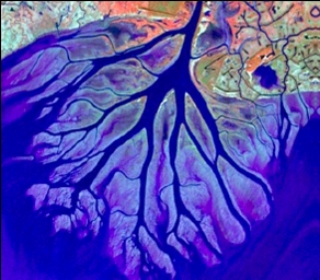
English: The Wax Lake Delta was formed by the deposition of sediment from a shipping canal off of the Atchafalaya River. The channel was routed through Wax Lake, which quickly filled with sediment. After Wax Lake filled, the sediment from the canal deposited offshore and created the delta. |
|||
| Date | ||||
| Source | National Center for Earth-surface Dynamics; http://www.nced.umn.edu/printview/Field_Site_Wax_Lake_Delta | |||
| Auteur | National Center for Earth-surface Dynamics | |||
| Autorisation (Réutilisation de ce fichier) |
|

| Lieu de la prise de vue | | Voir cet endroit et d’autres images sur : OpenStreetMap |
|---|
Historique du fichier
Cliquer sur une date et heure pour voir le fichier tel qu'il était à ce moment-là.
| Date et heure | Vignette | Dimensions | Utilisateur | Commentaire | |
|---|---|---|---|---|---|
| actuel | 19 décembre 2008 à 23:02 | | 292 × 256 (84 kio) | Awickert | {{Information |Description={{en|1=The Wax Lake Delta was formed by the deposition of sediment from a shipping canal off of the Atchafalaya River. The channel was routed through Wax Lake, which quickly filled with sediment. After Wax Lake filled, the sedim |
Utilisation du fichier
La page suivante utilise ce fichier :
Usage global du fichier
Les autres wikis suivants utilisent ce fichier :
- Utilisation sur de.wikipedia.org
- Utilisation sur en.wikipedia.org
- Utilisation sur es.wikipedia.org
- Utilisation sur www.wikidata.org